
|
Fragment of railway embankment
by Oliver Dixon
geograph for square SD3615
Seen from the car park of Sure Store, this vestigial remnant appears to be the... (more)
|

|
Course of Old Railway, Dingledow
by Mick Garratt
geograph for square NZ5611
An embankment betrays the route of an old railway siding to the bottom of the... (more)
|

|
Embankment at Blennerville
by Oliver Dixon
geograph for square Q8113
This slim embankment separates the estuary of the River Lee (to the left) from... (more)
|

|
Embankment beside a burn
by Lairich Rig
geograph for square NS3877
The embankment enters at the lower-right corner of the picture, and recedes into... (more)
|

|
Embankment beside a burn
by Lairich Rig
geograph for square NS3877
To the left of the embankment is an unnamed burn. On the other side of the burn... (more)
|

|
Woodhead Tramroad embankment
by Ian Calderwood
geograph for square SK0345
Below Gibridding Wood, the Woodhead Tramroad ran on this embankment to a bridge... (more)
|

|
Former embankment of Alston Branch Railway
by Andrew Curtis
for square NY7163
The disused railway embankment was broken by the building of the Haltwhistle... (more)
|

|
Railway embankment east of Llanfarian
by Nigel Brown
geograph for square SN5977
Category: Railway embankment
Now heavily overgrown, this embankment once carried the Manchester & Milford... (more)
|

|
Earth embankment near the Gaylet Pot, Seahills Farm, Angus
by Andrew Diack
geograph for square NO6743
This photo was taken from the Arbroath Cliff Trail and it shows an earth... (more)
|

|
Embankment of old mineral line
by Oliver Dixon
geograph for square NY8487
An old mineral line ran from the vicinity of Hareshaw House down to Bellingham.... (more)
|

|
Embankment at Sandpoint
by Lairich Rig
geograph for square NS3974
|
|
Embankment & train 2
by Mr Ignavy
geograph for square SU6552
Category: Railway embankment
|

|
Embankment & train
by Mr Ignavy
geograph for square SU6552
Category: Railway embankment
|

|
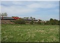
Railway embankment
by Mr Ignavy
geograph for square SU6552
Category: Railway embankment
East of Basingstoke station on the line to London.
|

|
Low wooded embankment in Victoria Park
by Oliver Dixon
geograph for square SD3216
This low wooded embankment shielded the western and northern side of Victoria... (more)
|

|
London - Bazalgette Embankment
by Colin Smith
geograph for square TQ3180
Ongoing construction work (2023) on the north bank of the Thames and to the west... (more)
|

|
Felling on the old railway embankment
by Neil Owen
geograph for square ST3339
The old Somerset and Dorset Joint Railway Bridgwater branch line was built... (more)
|

|
Former railway embankment beside Brenchley Gardens
by David Martin
geograph for square TQ3574
Not to be mistaken for just any grassy embankment, this was part of the railway... (more)
|

|
Embankment near Burnedge Pit site
by Kevin Waterhouse
geograph for square SD9110
This embankment built across a small side clough of Sudden Brook appears to be a... (more)
|

|
Embankment on disused L&NER Slanannan - Bo'ness section
by AlastairG
geograph for square NS8973
|

|
Embanked river
by Bob Harvey
geograph for square TF2829
This raised bank is the embankment of the River Glen, and all the fenland you... (more)
|

|
View of embankment near the old boathouse, Birling Gap
by Adrian Diack
geograph for square TV5596
This photo shows a west-northwest view of the grassy embankment near the old... (more)
|

|
Embankment which outcrops on clifftop as a high point of soil
by Adrian Diack
geograph for square TV5596
This photo shows an embankment by the side of the old Boat House garden in East... (more)
|

|
Embankment of old mineral line
by Oliver Dixon
for square NY8486
An old mineral line ran from the vicinity of Hareshaw House down to Bellingham.... (more)
|

|
Hemingford Abbots - Railway Embankment
by Colin Smith
geograph for square TL2771
The railway line that ran here is long gone and the embankment is now smothered by trees.
|

|
Wooded embankment, Market Weighton - Driffield railway
by Christine Johnstone
geograph for square SE8843
East of Wateringdike Lane, Goodmanham.
|

|
Forest of Dean Central Railway at Brimspill
by John Winder
geograph for square SO6906
This unprepossessing stretch of hedgerow marks the route of the Forest of Dean... (more)
|

|
Unused railway embankment
by John Winder
geograph for square SO6906
The Forest of Dean Central Railway was intended to capture much of the lucrative... (more)
|

|
Minor collapse on old railway embankment
by Trevor Littlewood
geograph for square NY9340
The northern end of an embankment of the long-closed Rookhope & Middlehope... (more)
|

|
Embankment, Great Central and Hull & Barnsley Joint Railway
by Christine Johnstone
geograph for square SE5606
West of Rostholme. No longer used by trains, but part of the Trans Pennine Trail... (more)
|

|
Embankment of disused railway line
by Trevor Littlewood
geograph for square NT5733
The railway embankment lies to the west of the A68, north of Newtown St... (more)
|

|
Gap in old railway embankment
by Trevor Littlewood
geograph for square NZ3023
An abandoned rail route once ran along the overgrown embankment which has been... (more)
|

|
Stream and embankment adjacent to the A58, Littleborough
by Humphrey Bolton
geograph for square SD9517
Travelling up the A58 the trees on each side hide the huge embankment on which... (more)
|

|
Old embankment beside the Gallangad Burn
by Lairich Rig
geograph for square NS4482
|

|
Embankment of former railway at Borrett
by David Smith
geograph for square SD6491
The trees cover the western slope of the embankment
|

|
Railway embankment across the mouth of Noss Creek
by David Smith
geograph for square SX8853
The water now flows through a culvert on the right. The embankment carries the... (more)
|

|
Road on embankment
by Trevor Littlewood
geograph for square SE6722
The embankment raises the road, the A614, to the height of the railway ahead so... (more)
|

|
Footpath on the embankment - The Ouse Washes near Welney
by Richard Humphrey
geograph for square TL5192
...
|

|
Autumn colours on a former railway embankment near Fordham
by Richard Humphrey
geograph for square TL6170
|

|
Old railway embankment near Belzies Farm
by Oliver Dixon
geograph for square NY0584
The Dumfries, Lochmaben and Lockerbie railway was built in 1863 and subsequently... (more)
|

|
Old railway embankment at Trailflat Farm
by Oliver Dixon
geograph for square NY0484
It would appear that the embankment has been removed in the next field, given... (more)
|

|
Iron Age embankment
by Alan Hughes
geograph for square SS8876
Iron Age embankment overgrown by trees at eastern edge of hill fort.
|

|
Wooded embankment, former Stokesley railway line
by Christine Johnstone
geograph for square NZ4306
With Lime Bridge's drain running towards it. The drain is also a parish boundary.
|

|
Railway embankment, Templepatrick (August 2014)
by Albert Bridge
geograph for square J2385
|

|
Earthen Bank - South Ham
by Mr Ignavy
geograph for square SU6151
Category: Embankment
A large embankment divides the Buckskin estate and the South Ham estate. To the... (more)
|

|
Flood embankment by the Cam
by Mr Ignavy
geograph for square TL5065
Category: Embankments
Looking north towards Bottisham Lock.
|

|
Flood plain embankment
by Mr Ignavy
geograph for square TL3671
Category: Embankments
Running along the southeast side of the river Great Ouse, just to the south of Chain Road.
|

|
Footpath along the embankment
by Mr Ignavy
geograph for square TL3671
Category: Embankments
Looking back (north) towards Chain Road.
|

|
View along the embankment
by Mr Ignavy
geograph for square TL3671
Category: Embankments
|

|
Path on the embankment by the canal
by Mr Ignavy
geograph for square TR1334
Category: Embankments
Part of the original protective design along the Royal Military Canal. See... (more)
|
