Distrito de Ungava
Aspeto
Este artigo ou secção contém uma lista de referências no fim do texto, mas as suas fontes não são claras porque não são citadas no corpo do artigo, o que compromete a confiabilidade das informações. (Junho de 2021) |

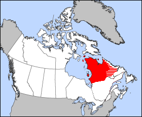
O Distrito de Ungava foi um distrito administrativo regional dos Territórios do Noroeste do Canadá, de 1895 a 1912. Cobria a porção norte do atual Quebéc, o interior de Labrador e as ilhas ao oeste e norte, as quais agora são partes de Nunavut.
Bibliografia
[editar | editar código-fonte]- Ballantyne, R. M. Ungava, A Tale of Esquimaux Land. London: J.M. Dent, 1908.
- Bergerud, A. T., Stuart N. Luttich, and Lodewijk Camps. The Return of Caribou to Ungava. McGill-Queen's native and northern series, 50. Montreal: McGill-Queen's University Press, 2007. ISBN 9780773532335
- Chown B, and M Lewis. 1956. "The Blood Group Genes of the Cree Indians and the Eskimos of the Ungava District of Canada". American Journal of Physical Anthropology. 14, no. 2: 215-24.
- Harper, Francis. The Friendly Montagnais and Their Neighbors in the Ungava Peninsula. Lawrence: University of Kansas, 1964.
- Harper, Francis. Birds of the Ungava Peninsula. Lawrence, Kan: University of Kansas, 1958.
- Lajoie, Paul G. Exploratory Soil Survey of the Fort Chimo District (Ungava Bay, Quebec). Ottawa: Experimental Farms Service, Canada Dept. of Agriculture, 1954.
- Murray, W. H. H. Mamelons, and Ungava, A Legend of the Saguenay. Boston: De Wolfe, Fiske & Co, 1890.
- Power, Geoffrey. The Salmon of Ungava Bay. [Montreal]: Arctic Institute of North America, 1969.
- Turner, Lucien M. Ethnology of the Ungava District, Hudson Bay Territory. Classics of Smithsonian anthropology. Washington, DC: Smithsonian Institution Press, 2001. ISBN 1560989653
- Twomey, Arthur C., and Nigel Herrick. Needle to the North, The Story of an Expedition to Ungava and the Belcher Islands. Houghton Mifflin, 1942.