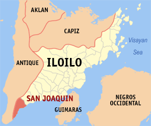
San Joaquin
Appearance
(Redirected from San Joaquin, Iloilo)
Page Module:Infobox/styles.css has no content.
| San Joaquin | |||
|---|---|---|---|
| Baley na Filipinas | |||
 | |||
| |||
 Lokasyon na San Joaquin | |||
 | |||
| 10°36′0″N 122°4′48″E | |||
| Dalin | Filipinas | ||
| Barangay | 85 | ||
| Kaawang | |||
| • Katiponan | 234.84 km2 (90.67 sq mi) | ||
| Elebasyon | 75 m (246 ft) | ||
| Bilang na too (Mayo 1, 2020)[1] | |||
| • Katiponan | 52,617 | ||
| • Densidad | 220/km2 (580/sq mi) | ||
| Economia | |||
| • Clase | unaan ya klase ya baley | ||
| • Ingresos | ₱191,773,310.05 (2020) | ||
| • Activos | ₱696,423,760.34 (2020) | ||
| • Pasivos | ₱108,881,375.59 (2020) | ||
| • Gastos | ₱107,145,553.31 (2020) | ||
| Kodigo na postal | 5024 | ||
| Kodigo na lugar | 33 | ||
| Website | www | ||
Say San Joaquin et unaan ya klase ya baley ed luyag na Iloilo, Filipinas. Unong ed 1 Mayo 2020 census, say populasyon to et 52,617 totoo tan 12,752 abong. Walay kabaleg tan sukat to ya 234.84 sq. km. Say zip code to et 5024.
Saray barangay
[dumaen | dumaen so pinanlapuan]- Amboyu-an
- Andres Bonifacio
- Antalon
- Bad-as
- Bagumbayan
- Balabago
- Baybay
- Bayunan
- Bolbogan
- Bulho
- Bucaya
- Cadluman
- Cadoldolan
- Camia
- Camaba-an
- Cata-an
- Crossing Dapuyan
- Cubay
- Cumarascas
- Dacdacanan
- Danawan
- Doldol
- Dongoc
- Escalantera
- Ginot-an
- Huna
- Igbaje
- Igbangcal
- Igbinangon
- Igburi
- Igcabutong
- Igcadlum
- Igcaphang
- Igcaratong
- Igcondao
- Igcores
- Igdagmay
- Igdomingding
- Iglilico
- Igpayong
- Jawod
- Langca
- Languanan
- Lawigan
- Lomboy
- Lopez Vito
- Mabini Norte
- Mabini Sur
- Manhara
- Maninila
- Masagud
- Matambog
- Mayunoc
- Montinola
- Nagquirisan
- Nadsadan
- Nagsipit
- New Gumawan
- Panatan
- Pitogo
- Purok 1 (Pob.)
- Purok 2 (Pob.)
- Purok 3 (Pob.)
- Purok 4 (Pob.)
- Purok 5 (Pob.)
- Qui-anan
- Roma
- San Luis
- San Mateo Norte
- San Mateo Sur
- Santiago
- Sinogbuhan
- Siwaragan
- Lomboyan (Santa Ana)
- Santa Rita
- Talagutac
- Tapikan
- Taslan
- Tiglawa
- Tiolas
- To-og
- Torocadan
- Ulay
- Bonga
- Guibongan Bayunan
Demograpiko
[dumaen | dumaen so pinanlapuan]| Taon | Pop. | ±% p.a. |
|---|---|---|
| 1903 | 14,333 | — |
| 1918 | 17,834 | +1.47% |
| 1939 | 23,779 | +1.38% |
| 1948 | 22,255 | −0.73% |
| 1960 | 24,655 | +0.86% |
| 1970 | 29,610 | +1.85% |
| 1975 | 32,352 | +1.79% |
| 1980 | 34,525 | +1.31% |
| 1990 | 39,958 | +1.47% |
| 1995 | 44,368 | +1.98% |
| 2000 | 47,826 | +1.62% |
| 2007 | 50,102 | +0.64% |
| 2010 | 51,645 | +1.11% |
| 2015 | 51,892 | +0.09% |
| 2020 | 52,617 | +0.27% |
| Reperensiya: Philippine Statistics Authority[2][3][4] | ||
Saray reperensiya
[dumaen | dumaen so pinanlapuan]- ↑ "2020 Census of Population and Housing (2020 CPH) Population Counts Declared Official by the President". Hulyo 7, 2021. https://psa.gov.ph/content/2020-census-population-and-housing-2020-cph-population-counts-declared-official-president.
- ↑ Census of Population (2015). "Region VI (Western Visayas)". Total Population by Province, City, Municipality and Barangay. PSA. Retrieved 29 June 2016.
- ↑ Census of Population and Housing (2010). "Region VI (Western Visayas)". Total Population by Province, City, Municipality and Barangay. NSO. Retrieved 29 June 2016.
- ↑ Censuses of Population (1903–2007). "Region VI (Western Visayas)". Table 1. Population Enumerated in Various Censuses by Province/Highly Urbanized City: 1903 to 2007. NSO.

