Atimonan
Appearance
| Atimonan | ||
|---|---|---|
| Baley na Filipinas | ||
 | ||
| ||
 Lokasyon na Atimonan | ||
 | ||
| 14°0′13″N 121°55′11″E | ||
| Dalin | Filipinas | |
| Angipaletnegan | Pebrero 4, 1608 | |
| Barangay | 42 | |
| Kaawang | ||
| • Katiponan | 239.66 km2 (92.53 sq mi) | |
| Elebasyon | 42 m (138 ft) | |
| Bilang na too (Mayo 1, 2020)[1] | ||
| • Katiponan | 64,260 | |
| • Densidad | 270/km2 (690/sq mi) | |
| Economia | ||
| • Clase | unaan ya klase ya baley | |
| • Ingresos | ₱260,229,688.63107,451,954.00119,372,228.65131,957,335.49149,876,019.00165,928,353.00183,426,677.51219,958,418.83271,916,925.16352,747,947.81 (2020) | |
| • Activos | ₱418,938,449.93184,292,876.00191,111,569.67216,965,165.97216,204,083.00272,077,605.00338,849,408.33349,291,336.92363,604,012.26479,480,065.65598,101,686.74 (2020) | |
| • Pasivos | ₱57,919,979.0027,836,926.0018,008,164.1119,589,773.9939,283,989.0058,700,885.0095,836,174.6881,150,278.6952,098,317.0252,293,739.9684,181,059.31 (2020) | |
| • Gastos | ₱209,971,561.4789,995,280.0089,080,913.95104,257,632.41119,877,698.00134,032,239.00157,137,184.94172,401,956.53184,199,040.22199,078,519.15259,657,631.19 (2020) | |
| Kodigo na postal | 4331 | |
| Kodigo na lugar | 42 | |
| Website |
www | |
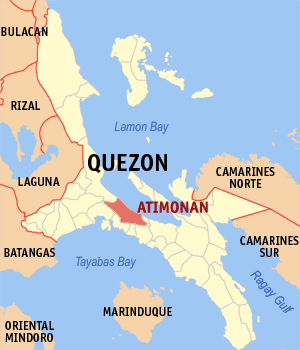
Say Atimonan et unaan ya klase ya baley ed luyag na Quezon, Filipinas. Unong ed 1 Mayo 2020 census, say populasyon to et 64,260 totoo tan 16,701 abong. Walay kabaleg tan sukat to ya 239.66 sq. km. Say zip code to et 4331.
Saray barangay
[dumaen | dumaen so pinanlapuan]- Angeles
- Balubad
- Balugohin
- Barangay Zone 1 (Pob.)
- Barangay Zone 2 (Pob.)
- Barangay Zone 3 (Pob.)
- Barangay Zone 4 (Pob.)
- Buhangin
- Caridad Ibaba
- Caridad Ilaya
- Habingan
- Inaclagan
- Inalig
- Kilait
- Kulawit
- Lakip
- Lubi
- Lumutan
- Magsaysay
- Malinao Ibaba
- Malinao Ilaya
- Malusak
- Manggalayan Bundok
- Manggalayan Labak
- Matanag
- Montes Balaon
- Montes Kallagan
- Ponon
- Rizal
- San Andres Bundok
- San Andres Labak
- San Isidro
- San Jose Balatok
- San Rafael
- Santa Catalina
- Sapaan
- Sokol
- Tagbakin
- Talaba
- Tinandog
- Villa Ibaba
- Villa Ilaya
Demograpiko
[dumaen | dumaen so pinanlapuan]| Taon | Pop. | ±% p.a. |
|---|---|---|
| 1903 | 11,203 | — |
| 1918 | 13,087 | +1.04% |
| 1939 | 18,512 | +1.67% |
| 1948 | 21,474 | +1.66% |
| 1960 | 32,294 | +3.46% |
| 1970 | 35,478 | +0.94% |
| 1975 | 37,483 | +1.11% |
| 1980 | 39,894 | +1.25% |
| 1990 | 46,651 | +1.58% |
| 1995 | 54,283 | +2.88% |
| 2000 | 56,716 | +0.94% |
| 2007 | 59,157 | +0.58% |
| 2010 | 61,587 | +1.48% |
| 2015 | 63,432 | +0.56% |
| 2020 | 64,260 | +0.26% |
| Reperensiya: Philippine Statistics Authority[2][3][4] | ||
Saray reperensiya
[dumaen | dumaen so pinanlapuan]- ↑ "2020 Census of Population and Housing (2020 CPH) Population Counts Declared Official by the President". Hulyo 7, 2021. https://psa.gov.ph/content/2020-census-population-and-housing-2020-cph-population-counts-declared-official-president.
- ↑ Census of Population (2015). "Region IV-A (Calabarzon)". Total Population by Province, City, Municipality and Barangay. PSA. Retrieved 29 June 2016.
- ↑ Census of Population and Housing (2010). "Region IV-A (Calabarzon)". Total Population by Province, City, Municipality and Barangay. NSO. Retrieved 29 June 2016.
- ↑ Censuses of Population (1903–2007). "Region IV-A (Calabarzon)". Table 1. Population Enumerated in Various Censuses by Province/Highly Urbanized City: 1903 to 2007. NSO.
