Nothing Special   »   [go: up one dir, main page]

File:Kilvebrickretort.jpg

Original file(425 × 640 pixels, file size: 86 KB, MIME type: image/jpeg)

Description
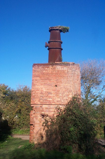
English: Old brick retort near Kilve beach This is the remains of an oil extractor built in the 1920's to process the oil rich shale in the cliffs. The ivy growing out of the stack has been shaped by the wind off the sea.
Date
Source From geograph.org.uk
Author Barbara Cook
Permission
(Reusing this file)
Creative Commons Attribution Share-alike license 2.0
Camera location51° 11′ 26.12″ N, 3° 13′ 34.64″ W Kartographer map based on OpenStreetMap.View this and other nearby images on: OpenStreetMapinfo


w:en:Creative Commons
attribution share alike
This file is licensed under the Creative Commons Attribution-Share Alike 2.0 Generic license.
Attribution: Barbara Cook
You are free:
  • to share – to copy, distribute and transmit the work
  • to remix – to adapt the work
Under the following conditions:
  • attribution – You must give appropriate credit, provide a link to the license, and indicate if changes were made. You may do so in any reasonable manner, but not in any way that suggests the licensor endorses you or your use.
  • share alike – If you remix, transform, or build upon the material, you must distribute your contributions under the same or compatible license as the original.


Original upload log

The original description page was here. All following user names refer to en.wikipedia.
  • 2007-12-31 21:59 Rodw 425×640×??? (87564 bytes) Old brick retort near Kilve beach This is the remains of an oil extractor built in the 1920's to process the oil rich shale in the cliffs. The ivy growing out of the stack has been shaped by the wind off the sea. Creative Commons Licence [Some Rights Rese

Captions

Add a one-line explanation of what this file represents

Items portrayed in this file

depicts

copyrighted<\/a>"}},"text\/plain":{"en":{"P6216":"copyrighted"}}}}" class="wbmi-entityview-statementsGroup wbmi-entityview-statementsGroup-P6216 oo-ui-layout oo-ui-panelLayout oo-ui-panelLayout-framed">
Creative Commons Attribution-ShareAlike 2.0 Generic<\/a>"}},"text\/plain":{"en":{"P275":"Creative Commons Attribution-ShareAlike 2.0 Generic"}}}}" class="wbmi-entityview-statementsGroup wbmi-entityview-statementsGroup-P275 oo-ui-layout oo-ui-panelLayout oo-ui-panelLayout-framed">

18 November 2005

file available on the internet<\/a>"}},"text\/plain":{"en":{"P7482":"file available on the internet"}}},"{\"value\":{\"entity-type\":\"property\",\"numeric-id\":137,\"id\":\"P137\"},\"type\":\"wikibase-entityid\"}":{"text\/html":{"en":{"":"operator<\/a>"}},"text\/plain":{"en":{"":"operator"}}},"{\"value\":{\"entity-type\":\"item\",\"numeric-id\":1503119,\"id\":\"Q1503119\"},\"type\":\"wikibase-entityid\"}":{"text\/html":{"en":{"P137":"Geograph Britain and Ireland<\/a>"}},"text\/plain":{"en":{"P137":"Geograph Britain and Ireland"}}},"{\"value\":{\"entity-type\":\"property\",\"numeric-id\":7384,\"id\":\"P7384\"},\"type\":\"wikibase-entityid\"}":{"text\/html":{"en":{"":"geograph.org.uk image ID<\/a>"}},"text\/plain":{"en":{"":"geograph.org.uk image ID"}}},"{\"value\":\"80352\",\"type\":\"string\"}":{"text\/html":{"en":{"P7384":"80352<\/a>"}},"text\/plain":{"en":{"P7384":"80352"}}},"{\"value\":{\"entity-type\":\"property\",\"numeric-id\":973,\"id\":\"P973\"},\"type\":\"wikibase-entityid\"}":{"text\/html":{"en":{"":"described at URL<\/a>"}},"text\/plain":{"en":{"":"described at URL"}}},"{\"value\":\"https:\\\/\\\/www.geograph.org.uk\\\/photo\\\/80352\",\"type\":\"string\"}":{"text\/html":{"en":{"P973":"https:\/\/www.geograph.org.uk\/photo\/80352<\/a>"}},"text\/plain":{"en":{"P973":"https:\/\/www.geograph.org.uk\/photo\/80352"}}}}" class="wbmi-entityview-statementsGroup wbmi-entityview-statementsGroup-P7482 oo-ui-layout oo-ui-panelLayout oo-ui-panelLayout-framed">

51°11'26.12"N, 3°13'34.64"W

Kodak DC280 Zoom<\/a>"}},"text\/plain":{"en":{"P4082":"Kodak DC280 Zoom"}}}}" class="wbmi-entityview-statementsGroup wbmi-entityview-statementsGroup-P4082 oo-ui-layout oo-ui-panelLayout oo-ui-panelLayout-framed">

0.00555555555555555555 second

8.8 millimetre

image/jpeg

File history

Click on a date/time to view the file as it appeared at that time.

Date/TimeThumbnailDimensionsUserComment
current10:12, 15 September 2008Thumbnail for version as of 10:12, 15 September 2008425 × 640 (86 KB)TimTay{{Information |Description={{en|Old brick retort near Kilve beach This is the remains of an oil extractor built in the 1920's to process the oil rich shale in the cliffs. The ivy growing out of the stack has been shaped by the wind off the sea.}} |Source=

The following 2 pages use this file:

Global file usage

The following other wikis use this file:

Metadata