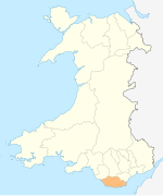
Penllyn, Vale of Glamorgan
Appearance
Penllyn
| |
|---|---|
Location within the Vale of Glamorgan | |
| Population | 1,506 (2011)[1] |
| OS grid reference | SS973761 |
| Community |
|
| Principal area | |
| Preserved county | |
| Country | Wales |
| Sovereign state | United Kingdom |
| Post town | Cowbridge |
| Postcode district | CF71 |
| Dialling code | 01446 |
| Police | South Wales |
| Fire | South Wales |
| Ambulance | Welsh |
| UK Parliament | |
| Senedd Cymru – Welsh Parliament | |
Penllyn (Welsh: Pen-llin) is a village and community in the Vale of Glamorgan, Wales. It is located north west of the market town of Cowbridge. As a community it contains the settlements of Llansannor, Pentre Meyrick, Trerhyngyll, Ystradowen and Penllyn itself.[2]
Penllyn is home to Penllyn Castle, a 12th-century fortification which, although ruinous, is now adjoined by a castellated mansion originally built in the late 16th century.
The smaller hamlet of Graig Penllyn, about 1.3 miles (2.1 km) north of the main village, is notable for its pub the Barley Mow.[3][4]

Notes
[edit]- ^ "Community population 2011". Retrieved 9 April 2015.
- ^ Davies, John; Jenkins, Nigel; Menna, Baines; Lynch, Peredur I., eds. (2008). The Welsh Academy Encyclopaedia of Wales. Cardiff: University of Wales Press. p. 492. ISBN 978-0-7083-1953-6.
- ^ "The Barley Mow Inn, a pub in Cowbridge, South Wales". cowbridgeguide.co.uk. Retrieved 30 September 2016.
- ^ "Barley Mow, Craig Penllyn". whatpub.com. Retrieved 30 September 2016.

