Portal:World


The world is the totality of entities, the whole of reality, or everything that exists. The nature of the world has been conceptualized differently in different fields. Some conceptions see the world as unique while others talk of a "plurality of worlds". Some treat the world as one simple object while others analyze the world as a complex made up of parts.
In scientific cosmology, the world or universe is commonly defined as "[t]he totality of all space and time; all that is, has been, and will be". Theories of modality talk of possible worlds as complete and consistent ways how things could have been. Phenomenology, starting from the horizon of co-given objects present in the periphery of every experience, defines the world as the biggest horizon or the "horizon of all horizons". In philosophy of mind, the world is contrasted with the mind as that which is represented by the mind.
Theology conceptualizes the world in relation to God, for example, as God's creation, as identical to God or as the two being interdependent. In religions, there is a tendency to downgrade the material or sensory world in favor of a spiritual world to be sought through religious practice. A comprehensive representation of the world and our place in it, as is found in religions, is known as a worldview. Cosmogony is the field that studies the origin or creation of the world while eschatology refers to the science or doctrine of the last things or of the end of the world.
In various contexts, the term "world" takes a more restricted meaning associated, for example, with the Earth and all life on it, with humanity as a whole or with an international or intercontinental scope. In this sense, world history refers to the history of humanity as a whole and world politics is the discipline of political science studying issues that transcend nations and continents. Other examples include terms such as "world religion", "world language", "world government", "world war", "world population", "world economy", or "world championship". (Full article...)
-
United States Army infantry supported by a M18 tank destroyer advancing through an enemy-occupied town during World War II, the most recent conflict to widely be considered a "world war"
A world war is an international conflict that involves most or all of the world's major powers. Conventionally, the term is reserved for two major international conflicts that occurred during the first half of the 20th century, World War I (1914–1918) and World War II (1939–1945), although some historians have also characterised other global conflicts as world wars, such as the Nine Years' War, the War of the Spanish Succession, the Seven Years' War, the French Revolutionary and Napoleonic Wars, the Cold War, and the War on Terror. (Full article...) -
Global mental health is the international perspective on different aspects of mental health. It is 'the area of study, research and practice that places a priority on improving mental health and achieving equity in mental health for all people worldwide'. There is a growing body of criticism of the global mental health movement, and has been widely criticised as a neo-colonial or "missionary" project and as primarily a front for pharmaceutical companies seeking new clients for psychiatric drugs.
In theory, taking into account cultural differences and country-specific conditions, it deals with the epidemiology of mental disorders in different countries, their treatment options, mental health education, political and financial aspects, the structure of mental health care systems, human resources in mental health, and human rights issues among others. (Full article...) -
A world map on the Winkel tripel projection,
a low-error map projection adopted by the National Geographic Society for reference maps
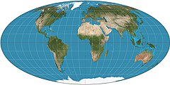
A world map is a map of most or all of the surface of Earth. World maps, because of their scale, must deal with the problem of projection. Maps rendered in two dimensions by necessity distort the display of the three-dimensional surface of the Earth. While this is true of any map, these distortions reach extremes in a world map. Many techniques have been developed to present world maps that address diverse technical and aesthetic goals.
Charting a world map requires global knowledge of the Earth, its oceans, and its continents. From prehistory through the Middle Ages, creating an accurate world map would have been impossible because less than half of Earth's coastlines and only a small fraction of its continental interiors were known to any culture. With exploration that began during the European Renaissance, knowledge of the Earth's surface accumulated rapidly, such that most of the world's coastlines had been mapped, at least roughly, by the mid-1700s and the continental interiors by the twentieth century. (Full article...) -
World map of countries and territories by HDI scores in increments of 0.050 (based on 2022 data, published in 2024) - ≥ 0.950
- 0.900–0.950
- 0.850–0.899
- 0.800–0.849
- 0.750–0.799
- 0.700–0.749
- 0.650–0.699
- 0.600–0.649
- 0.550–0.599
- 0.500–0.549
- 0.450–0.499
- 0.400–0.449
- ≤ 0.399
- Data unavailable
The Human Development Index (HDI) is a statistical composite index of life expectancy, education (mean years of schooling completed and expected years of schooling upon entering the education system), and per capita income indicators, which is used to rank countries into four tiers of human development. A country scores a higher level of HDI when the lifespan is higher, the education level is higher, and the gross national income GNI (PPP) per capita is higher. It was developed by Pakistani economist Mahbub ul-Haq and was further used to measure a country's development by the United Nations Development Programme (UNDP)'s Human Development Report Office.
The 2010 Human Development Report introduced an Inequality-adjusted Human Development Index (IHDI). While the simple HDI remains useful, it stated that "the IHDI is the actual level of human development (accounting for this inequality), while the HDI can be viewed as an index of 'potential' human development (or the maximum level of HDI) that could be achieved if there was no inequality." (Full article...) -
Chart of the world's gross domestic product over the last two millennia
The global financial system is the worldwide framework of legal agreements, institutions, and both formal and informal economic action that together facilitate international flows of financial capital for purposes of investment and trade financing. Since emerging in the late 19th century during the first modern wave of economic globalization, its evolution is marked by the establishment of central banks, multilateral treaties, and intergovernmental organizations aimed at improving the transparency, regulation, and effectiveness of international markets. In the late 1800s, world migration and communication technology facilitated unprecedented growth in international trade and investment. At the onset of World War I, trade contracted as foreign exchange markets became paralyzed by money market illiquidity. Countries sought to defend against external shocks with protectionist policies and trade virtually halted by 1933, worsening the effects of the global Great Depression until a series of reciprocal trade agreements slowly reduced tariffs worldwide. Efforts to revamp the international monetary system after World War II improved exchange rate stability, fostering record growth in global finance.
A series of currency devaluations and oil crises in the 1970s led most countries to float their currencies. The world economy became increasingly financially integrated in the 1980s and 1990s due to capital account liberalization and financial deregulation. A series of financial crises in Europe, Asia, and Latin America followed with contagious effects due to greater exposure to volatile capital flows. The global financial crisis, which originated in the United States in 2007, quickly propagated among other nations and is recognized as the catalyst for the worldwide Great Recession. A market adjustment to Greece's noncompliance with its monetary union in 2009 ignited a sovereign debt crisis among European nations known as the Eurozone crisis. The history of international finance shows a U-shaped pattern in international capital flows: high prior to 1914 and after 1989, but lower in between. The volatility of capital flows has been greater since the 1970s than in previous periods. (Full article...) -
The BBC World Service is an international broadcaster owned and operated by the BBC. It is the world's largest external broadcaster in terms of reception area, language selection and audience reach. It broadcasts radio news, speech and discussions in more than 40 languages to many parts of the world on analogue and digital shortwave platforms, internet streaming, podcasting, satellite, DAB, FM and MW relays. In 2015, the World Service reached an average of 210 million people a week (via TV, radio and online). In November 2016, the BBC announced that it would start broadcasting in additional languages including Amharic and Igbo, in its biggest expansion since the 1940s.
BBC World Service English maintains eight regional feeds with several programme variations, covering, respectively, East and South Africa; West and Central Africa; Europe and Middle East; the Americas and Caribbean; East Asia; South Asia; Australasia; and the United Kingdom. There are also two separate online-only streams with one being more news-oriented, known as News Internet. The service broadcasts 24 hours a day. (Full article...) -
The World Factbook, also known as the CIA World Factbook, is a reference resource produced by the Central Intelligence Agency (CIA) with almanac-style information about the countries of the world. The official print version is available from the Government Publishing Office. The Factbook is available in the form of a website that is partially updated every week. It is also available for download for use off-line. It provides a two- to three-page summary of the demographics, geography, communications, government, economy, and military of 266 international entities, including U.S.-recognized countries, dependencies, and other areas in the world.
The World Factbook is prepared by the CIA for the use of U.S. government officials, and its style, format, coverage, and content are primarily designed to meet their requirements. It is also frequently used as a resource for academic research papers and news articles. As a work of the U.S. government, it is in the public domain in the United States. (Full article...)


-
Satellite time lapse imagery of Earth's rotation showing axis tilt (from Earth)
-
A 2012 artistic impression of the early Solar System's protoplanetary disk from which Earth and other Solar System bodies were formed (from Earth)
-
-
Image of the physical world, captured by the Hubble Space Telescope (from World)
-
Change in average surface air temperature and drivers for that change. Human activity has caused increased temperatures, with natural forces adding some variability. (from Earth)
-
-
Vitruvian Man by Leonardo da Vinci epitomizes the advances in art and science seen during the Renaissance. (from History of Earth)
-
Peopling of the world, the Southern Dispersal scenario
-
Cross-section through a liposome (from History of Earth)
-
"Lucy", the first Australopithecus afarensis skeleton found, was only 1.06 m (3 ft 6 in) tall.
-
Artist's conception of Hadean Eon Earth, when it was much hotter and inhospitable to all forms of life. (from History of Earth)
-
An animation of the changing density of productive vegetation on land (low in brown; heavy in dark green) and phytoplankton at the ocean surface (low in purple; high in yellow) (from Earth)
-
Earth's night-side upper atmosphere appearing from the bottom as bands of afterglow illuminating the troposphere in orange with silhouettes of clouds, and the stratosphere in white and blue. Next the mesosphere (pink area) extends to the orange and faintly green line of the lowest airglow, at about one hundred kilometers at the edge of space and the lower edge of the thermosphere (invisible). Continuing with green and red bands of aurorae stretching over several hundred kilometers. (from Earth)
-
A view of Earth with different layers of its atmosphere visible: the troposphere with its clouds casting shadows, a band of stratospheric blue sky at the horizon, and a line of green airglow of the lower thermosphere around an altitude of 100 km, at the edge of space (from Earth)
-
Empires of the world in 1898
-
Chennakesava Temple, Belur, India
-
Florence, birthplace of the Italian Renaissance
-
Battle during the 1281 Mongol invasion of Japan
-
Great Mosque of Kairouan, Tunisia, founded 670 CE
-
First airplane, the Wright Flyer, flew on 17 December 1903.
-
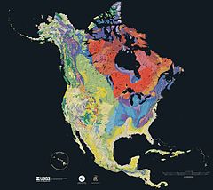
Geologic map of North America, color-coded by age. From most recent to oldest, age is indicated by yellow, green, blue, and red. The reds and pinks indicate rock from the Archean.
-
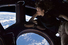
Tracy Caldwell Dyson, a NASA astronaut, observing Earth from the Cupola module at the International Space Station on 11 September 2010 (from Earth)
-
A reconstruction of human history based on fossil data. (from History of Earth)
-
Tiktaalik, a fish with limb-like fins and a predecessor of tetrapods. Reconstruction from fossils about 375 million years old. (from History of Earth)
-
Earth's land use for human agriculture in 2019 (from Earth)
-
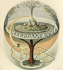
Yggdrasil, an attempt to reconstruct the Norse world tree which connects the heavens, the world, and the underworld. (from World)
-
Great Pyramids of Giza, Egypt
-
A view of Earth with its global ocean and cloud cover, which dominate Earth's surface and hydrosphere; at Earth's polar regions, its hydrosphere forms larger areas of ice cover. (from Earth)
-
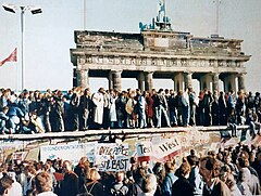
Fall of the Berlin Wall, 1989
-
Obelisk of Axum, Ethiopia
-
Standing Buddha from Gandhara, 2nd century CE
-
-
A composite image of Earth, with its different types of surface discernible: Earth's surface dominating Ocean (blue), Africa with lush (green) to dry (brown) land and Earth's polar ice in the form of Antarctic sea ice (grey) covering the Antarctic or Southern Ocean and the Antarctic ice sheet (white) covering Antarctica. (from Earth)
-
Olmec colossal head, now at the Museo de Antropología de Xalapa
-
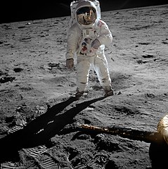
Last Moon landing: Apollo 17 (1972)
-
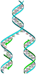
The replicator in virtually all known life is deoxyribonucleic acid. DNA is far more complex than the original replicator and its replication systems are highly elaborate. (from History of Earth)
-
Angkor Wat temple complex, Cambodia, early 12th century
-
Ajloun Castle, Jordan
-
Lithified stromatolites on the shores of Lake Thetis, Western Australia. Archean stromatolites are the first direct fossil traces of life on Earth. (from History of Earth)
-
-
Chloroplasts in the cells of a moss (from History of Earth)
-
-
-
The pale orange dot, an artist's impression of the early Earth which might have appeared orange through its hazy methane rich prebiotic second atmosphere. Earth's atmosphere at this stage was somewhat comparable to today's atmosphere of Titan. (from History of Earth)
-
-
A map of heat flow from Earth's interior to the surface of Earth's crust, mostly along the oceanic ridges (from Earth)
-
-
-
Machu Picchu, Inca Empire, Peru
-
Earth's axial tilt causing different angles of seasonal illumination at different orbital positions around the Sun (from Earth)
-
-
Artist's rendition of an oxinated fully-frozen Snowball Earth with no remaining liquid surface water. (from History of Earth)
-
COVID-19 pandemic, 2020 (from Human history)
-
Graph showing range of estimated partial pressure of atmospheric oxygen through geologic time (from History of Earth)
-
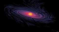
An artist's rendering of a protoplanetary disk (from History of Earth)
-
Dinosaurs were the dominant terrestrial vertebrates throughout most of the Mesozoic (from History of Earth)
-
Notre-Dame de Paris, France
-
Earth's western hemisphere showing topography relative to Earth's center instead of to mean sea level, as in common topographic maps (from Earth)
-
Trilobites first appeared during the Cambrian period and were among the most widespread and diverse groups of Paleozoic organisms. (from History of Earth)
-
Artist's impression of Earth during the later Archean, the largely cooled planetary crust and water-rich barren surface, marked by volcanoes and continents, features already round microbialites. The Moon, still orbiting Earth much closer than today and still dominating Earth's sky, produced strong tides. (from History of Earth)
-
-
Benin Bronze head from Nigeria
-
A computer-generated image mapping the prevalence of artificial satellites and space debris around Earth in geosynchronous and low Earth orbit (from Earth)
-
Shanghai. China urbanized rapidly in the 21st century.
-
Japanese depiction of a Portuguese carrack. European maritime innovations led to proto-globalization.
-
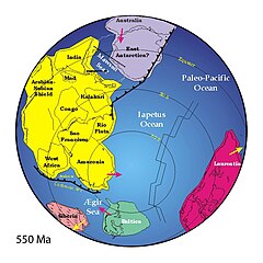
A reconstruction of Pannotia (550 Ma). (from History of Earth)
-
Artist's conception of Devonian flora (from History of Earth)
-
Earth's history with time-spans of the eons to scale. Mameans "million years ago". (from History of Earth)
-
-
-
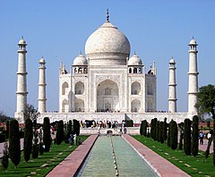
Taj Mahal, Mughal Empire, India
-
An artist's impression of the Archean, the eon after Earth's formation, featuring round stromatolites, which are early oxygen-producing forms of life from billions of years ago. After the Late Heavy Bombardment, Earth's crust had cooled, its water-rich barren surface is marked by continents and volcanoes, with the Moon still orbiting Earth half as far as it is today, appearing 2.8 times larger and producing strong tides. (from Earth)
-
A schematic view of Earth's magnetosphere with solar wind flowing from left to right (from Earth)
-
-
A composite image of artificial light emissions at night on a map of Earth (from Earth)
-
Pangaea was a supercontinent that existed from about 300 to 180 Ma. The outlines of the modern continents and other landmasses are indicated on this map. (from History of Earth)
-
Ming dynasty section, Great Wall of China
-
Persepolis, Achaemenid Empire, 6th century BCE
-
Pale orange dot, an artist's impression of Early Earth, featuring its tinted orange methane-rich early atmosphere (from Earth)
-
Artist's impression of the enormous collision that probably formed the Moon (from History of Earth)
-
An artist's impression of ice age Earth at glacial maximum. (from History of Earth)
-
-
A banded iron formation from the 3.15 Ga Moodies Group, Barberton Greenstone Belt, South Africa. Red layers represent the times when oxygen was available; gray layers were formed in anoxic circumstances. (from History of Earth)
-
13th-century French historiated initial with the three classes of medieval society: those who prayed (the clergy), those who fought (the knights), and those who worked (the peasantry) (from Human history)
-
A 580 million year old fossil of Spriggina floundensi, an animal from the Ediacaran period. Such life forms could have been ancestors to the many new forms that originated in the Cambrian Explosion. (from History of Earth)
-
A pillar at Göbekli Tepe
-
Artist's impression of a Hadean landscape with the relatively newly formed Moon still looming closely over Earth and both bodies sustaining strong volcanism. (from History of Earth)
-


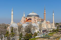


Istanbul is the largest city in Turkey, straddling the Bosporus Strait, the boundary between Europe and Asia. It is considered the country's economic, cultural and historic capital. The city has a population of over 15 million residents, comprising 19% of the population of Turkey, and is the most populous city in Europe and the world's fifteenth-largest city.
The city was founded as Byzantium in the 7th century BCE by Greek settlers from Megara. In 330 CE, the Roman emperor Constantine the Great made it his imperial capital, renaming it first as New Rome (Ancient Greek: Νέα Ῥώμη Nea Rhomē; Latin: Nova Roma) and then finally as Constantinople (Constantinopolis) after himself. In 1930, the city's name was officially changed to Istanbul, the Turkish rendering of εἰς τὴν Πόλιν eis tḕn Pólin 'to the City', the appellation Greek speakers used since the 11th century to colloquially refer to the city. (Full article...)
- ... that more than a decade after Edgar Wright assembled the cast of Scott Pilgrim vs. the World, he helped to convince them all to reprise their roles in an anime adaptation of the source material?
- ... that CEO Marla Messing submitted the business plan for the 1999 FIFA Women's World Cup two days before the birth of her first child?
- ... that the urban legend Herobrine was ranked on a Guinness World Records poll of the best video game villains, despite never existing?
- ... that communist propagandist Jian Xianfo gave birth to her son in an earthwork during the Long March?
- ... that in 1991, Juan López Mella was the first Spanish rider to achieve a podium place in the Superbike World Championship?
- ... that both finalists at the 2008 World Snooker Championship made maximum breaks during the tournament?
- ... that due to his Hungarian background, composer Henri Berény was banned from living and working in Paris during World War I and his home was seized by the French government?
- ... that the 1968 Ruby Tower collapse was caused by an earthquake centered more than 200 km (120 mi) away?

Slovakia (/sloʊˈvækiə, -ˈvɑːk-/ ; Slovak: Slovensko [ˈslɔʋenskɔ] ), officially the Slovak Republic (Slovak: Slovenská republika [ˈslɔʋenskaː ˈrepublika] ), is a landlocked country in Central Europe. It is bordered by Poland to the north, Ukraine to the east, Hungary to the south, Austria to the west, and the Czech Republic to the northwest. Slovakia's mostly mountainous territory spans about 49,000 square kilometres (19,000 sq mi), hosting a population exceeding 5.4 million. The capital and largest city is Bratislava, while the second largest city is Košice.
The Slavs arrived in the territory of the present-day Slovakia in the 5th and 6th centuries. From the late 6th century, parts of modern Slovakia were incorporated in the Avar Khaghanate. In the 7th century, the Slavs played a significant role in the creation of Samo's Empire. In the 9th century, the Avar Khaghanate dissolved, and the Slavs established the Principality of Nitra, which was later conquered by the Principality of Moravia, leading to the formation of Great Moravia. In the 10th century, after the dissolution of Great Moravia, the territory was integrated into the Principality of Hungary, which then became the Kingdom of Hungary in 1000. In 1241 and 1242, after the Mongol invasion of Europe, much of the territory was destroyed, but was recovered largely thanks to Béla IV. (Full article...)
Various lists of the Wonders of the World have been compiled from antiquity to the present day, in order to catalogue the world's most spectacular natural features and human-built structures.The Seven Wonders of the Ancient World is the oldest known list of this type, documenting the most remarkable human-made creations of classical antiquity; it was based on guidebooks popular among Hellenic sightseers and as such only includes works located around the Mediterranean rim and in the ancient Near East. The number seven was chosen because the Greeks believed it represented perfection and plenty, and because it reflected the number of planets known in ancient times (five) plus the Sun and Moon. (Full article...)
-
Protected areas of Indonesia comprise both terrestrial and marine environments in any of the six IUCN Protected Area categories. There are over 500 protected areas in Indonesia, of which 54 National Parks cover 16.4 million ha, and another 527 nature and game reserves cover a further 28.3 million ha. The total protected land area represents over 15% of Indonesia's landmass. Marine Protected Areas comprise over 15.7 million ha representing ca. 5% of territorial waters. (Full article...)
-
Forests in the state of Himachal Pradesh (northern India) currently cover an area of nearly 37,939 square kilometres (14,648 sq mi), which is about 68.16% of the total land area of the state. The forests were once considered to be the main source of income of the state and most of the original forests were clear felled. The emphasis has shifted, however, from exploitation to conservation. The state government aims to increase forest cover to 50% of the total land area. There have been various projects, including the establishment of protected areas such as National Parks, designed to preserve and expand the forests. (Full article...)
-
-
This is a list of protected areas of Romania.
About 5.18% of the area of Romania has a protected status (12,360 km2), including the Danube Delta, which makes half of these areas (2.43% of Romania's area). (Full article...) -
Protected areas of Estonia are regulated by the Nature Conservation Act (Estonian: Looduskaitseseadus), which was passed by the Estonian parliament on April 21, 2004 and entered into force May 10, 2004.
Overall Estonia has 15403 protected areas covering 21% of the country land and 18% of it marine and coastal territory, including 6 national parks: Lahemaa National Park, Karula National Park, Soomaa National Park,Vilsandi National Park, Matsalu National Park, and Alutaguse National Park (Full article...) -
The protected areas of Finland include national parks, nature reserves and other areas, with a purpose of conserving areas of all of Finland's ecosystems and biotopes.
Protected areas include:- National parks of Finland (Kansallispuisto/Nationalpark) - 8,170 km2
- Strict nature reserves of Finland (Luonnonpuisto/Naturreservat) - 1,530 km2
- Mire reserves of Finland (Soidensuojelualue/Myrskyddsområde) - 4,490 km2
- Protected herb-rich forest areas (Lehtojensuojelualue/Lundskyddsområde) - 13 km2
- Protected old-growth forest areas (Vanhat metsät/Gamla skogar) - 100 km2
- Grey seal protection areas (Hylkeidensuojelualue/Sälskyddsområde) - 190 km2
- Other protected areas on state-owned land - 468 km2
-
A family of Asiatic lions at Gir National Park
The Gujarat state of western India has four National Parks and twenty-three wildlife sanctuaries which are managed by the Forest Department of the Government of Gujarat. (Full article...) -
Cape Spencer Lighthouse, Innes National Park
Protected areas of South Australia, consisting of protected areas located within South Australia and its immediate onshore waters and which are managed by South Australian Government agencies. As of 2018, South Australia contained 359 separate protected areas declared under the National Parks and Wildlife Act 1972, the Crown Land Management Act 2009 and the Wilderness Protection Act 1992. Together, they cover a total land area of 211,387.48 km2 (81,617.16 sq mi) or 21.5% of the state's area. (Full article...) -
A National Biodiversity Conservation Area (NBCA) is an environmentally protected area in Laos. There are all together 21 different NBCAs in Laos, protecting 29,775 square kilometers. Another 10 NBCAs have been proposed, many of them being treated by authorities as though they were already officially protected. (Full article...)
-
This is a list of protected areas of Afghanistan.
- Ab-i-Estada Nature Reserve, Ghazni Province
- Ajar Valley Nature Reserve, Bamyan Province
- Bamiyan National Heritage Park, Bamyan Province
- Bamiyan Plateau Protected Landscape, Bamyan Province
- Band-e Amir National Park, Bamyan Province
- Darqad (Takhar) Wildlife Reserve, Takhar Province
- Dasht-i-Nawar Waterfowl Sanctuary, Ghazni Province
- Hamun-i-Puzak Waterfowl Sanctuary, Farah and Nimroz provinces
- Imam Sahib (Kunduz) Wildlife Reserve, Kunduz Province
- Khulm Landmark Protected Area, Balkh Province
- Koh-e Baba (Shah Foladi) Protected Landscape, Bamyan province
- Kol-i-Hashmat Khan Waterfowl Sanctuary, Kabul Province
- Northwest Afghanistan Game Managed Reserve, Herat Province
- Nuristan National Park and Wildlife Reserve, Nuristan Province
- Pamir-i-Buzurg Wildlife Reserve, Badakhshan Province
- Registan Desert Wildlife Managed Reserve, Kandahar Province
- Wakhan National Park, Badakhshan Province
- Zadran National Reserve, Paktia Province
-
This is a list of protected areas of Cambodia.
A total of 8 forms of protected area are recognized under the Cambodian Protected Area Law of 2008. These are: (Full article...) -
The Protected areas of Portugal (Portuguese: Áreas protegidas de Portugal) are classified under a legal protection statute that allows for the adequate protection and maintenance of biodiversity, while providing services for ecosystem that maintains the natural and geological patrimony. (Full article...)
-
Kejimkujik National Park, Little River
This is a list of protected areas of Nova Scotia. (Full article...) -
The Protected areas of New South Wales include both terrestrial and marine protected areas. there are 225 national parks in New South Wales. A number established since the late 1970s followed campaigns by local residents and environmentalists.
Based on the Collaborative Australian Protected Area Database (CAPAD) 2020 data there are 2136 separate terrestrial protected areas with a total land area of 7,696,641 hectares (19,018,810 acres) (9.61% of the state's area). CAPAD data also shows 18 marine protected areas with a total area of 348,849 hectares (862,020 acres), covering 39.63% of NSW waters. (Full article...) -


-
United Nations Human Development Index map by country (2016)
-
Index map from the International Map of the World (1:1,000,000 scale)
-
A plate tectonics map with volcano locations indicated with red circles
-
The world map by Gerardus Mercator (1569), the first map in the well-known Mercator projection
-
The Goode homolosine projection is a pseudocylindrical, equal-area, composite map projection used for world maps.
-
Mollweide projection of the world
-
Only a few of the largest large igneous provinces appear (coloured dark purple) on this geological map, which depicts crustal geologic provinces as seen in seismic refraction data
-
Time zones of the world
-
1516 map of the world by Martin Waldseemüller


- List of Olympic records in athletics
- List of world records in athletics
- List of junior world records in athletics
- List of world records in masters athletics
- List of world youth bests in athletics
- List of IPC world records in athletics
- List of world records in canoeing
- List of world records in chess
- List of cycling records
- List of world records in track cycling
- List of world records in finswimming
- List of world records in juggling
- List of world records in rowing
- List of world records in speed skating
- List of world records in swimming
- List of IPC world records in swimming
- List of world records in Olympic weightlifting

Continents of Earth | ||||||||
|---|---|---|---|---|---|---|---|---|
| ||||||||
| ||||||||
| ||||||||


| Cenozoic Era (present–66.0 Ma) |
| ||||||||||||
|---|---|---|---|---|---|---|---|---|---|---|---|---|---|
| Mesozoic Era (66.0–252 Ma) |
| ||||||||||||
| Paleozoic Era (252–539 Ma) |
| ||||||||||||
| Proterozoic Eon (539 Ma–2.5 Ga) |
| ||||||||||||
| Archean Eon (2.5–4 Ga) | |||||||||||||
| Hadean Eon (4–4.6 Ga) | |||||||||||||
ka = kiloannum (thousands years ago); Ma = megaannum (millions years ago); Ga = gigaannum (billions years ago). See also: Geologic time scale • | |||||||||||||
| Locations | ||
|---|---|---|
| Related | ||

| |||||||||||||||||||
| |||||||||||||||||||
| |||||||||||||||||||

Economic classification of countries | |||||
|---|---|---|---|---|---|
| Three-World Model | |||||
| Gross domestic product (GDP) |
| ||||
| Gross national income (GNI) | |||||
| Wages | |||||
| Wealth | |||||
| Other national accounts | |||||
| Human development | |||||
| Digital divide | |||||
| Net international investment position (NIIP) | |||||
| Technological |
| ||||
|---|---|---|---|---|---|
| Sociological | |||||
| Ecological |
| ||||
| Biological |
| ||||
| Astronomical | |||||
| Eschatological |
| ||||
| Others |
| ||||
| Fictional | |||||
| Organizations | |||||

The following Wikimedia Foundation sister projects provide more on this subject:
-
Commons
Free media repository -
Wikibooks
Free textbooks and manuals -
Wikidata
Free knowledge base -
Wikinews
Free-content news -
Wikiquote
Collection of quotations -
Wikisource
Free-content library -
Wikispecies
Directory of species -
Wikiversity
Free learning tools -
Wikivoyage
Free travel guide -
Wiktionary
Dictionary and thesaurus


