The Northwest Coast is the coastal region of the Pacific Northwest, and the Northwest Plateau (also commonly known as "the Interior" in British Columbia), is the inland region. The term "Pacific Northwest" should not be confused with the Northwest Territory (also known as the Great Northwest, a historical term in the United States) or the Northwest Territories of Canada. The region is sometimes referred to as Cascadia, which, depending on the borders, may or may not be the same thing as the Pacific Northwest.
The region's largest metropolitan areas are Greater Seattle, Washington, with 4 million people; Metro Vancouver, British Columbia, with 2.84 million people; and Greater Portland, Oregon, with 2.5 million people.
The culture of the Pacific Northwest is influenced by the Canada–United States border, which the United States and the United Kingdom established at a time when the region's inhabitants were composed mostly of indigenous peoples. Two sections of the border—one along the 49th parallel south of British Columbia and one between the Alaska Panhandle and northern British Columbia—have left a great impact on the region. According to Canadian historian Ken Coates, the border has not merely influenced the Pacific Northwest—rather, "the region's history and character have been determined by the boundary". (Full article...)
Muzak is an American brand of background music played in retail stores and other public establishments.
The name Muzak, a blend of music and the popular camera brand name Kodak, has been in use since 1934 and has been owned by various companies. The word Muzak has been a registered trademark of Muzak LLC since December 21, 1954. (Full article...)
Image 8The 1980 eruption of Mount St. Helens (from Cascade Range)
Image 9The Boundary Trail section of the PNT in Horseshoe Basin, Pasayten Wilderness (from Pacific Northwest Trail)
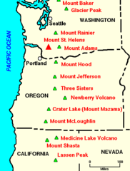
Image 10Magnetic anomalies around the Juan de Fuca and Gorda Ridges, off the west coast of North America, color coded by age. (from Geology of the Pacific Northwest)
Image 20Public transportation is used in the Pacific Northwest region. Vancouver's SkyTrain rapid transit system achieves daily ridership of over 500,000 passengers per day on weekdays and the overall transit ridership levels in the Metro Vancouver area rank third in North America per capita. (from Pacific Northwest)
Image 21Map of "megacity", showing population density (shades of yellow/brown), highways (red), and major railways (black). Public land shown in shades of green. (from Pacific Northwest)
Image 23The Coast Mountains are heavily eroded by glaciers, including Mount Waddington (far background, center). (from Geology of the Pacific Northwest)
Image 37None of the multiple possible definitions of the Pacific Northwest is universally accepted. This map shows three possibilities: (1) The shaded area shows the historical Oregon Country. (2) The green line shows the Cascadia bioregion. (3) The labeled states and provinces include Washington, Idaho, Oregon and British Columbia. (from Pacific Northwest)
Image 38The immense floods created channels that are presently dry, such as the Drumheller Channels (from Geology of the Pacific Northwest)