Portal:Tropical cyclones

A tropical cyclone is a storm system characterized by a large low-pressure center, a closed low-level circulation and a spiral arrangement of numerous thunderstorms that produce strong winds and heavy rainfall. Tropical cyclones feed on the heat released when moist air rises, resulting in condensation of water vapor contained in the moist air. They are fueled by a different heat mechanism than other cyclonic windstorms such as Nor'easters, European windstorms and polar lows, leading to their classification as "warm core" storm systems. Most tropical cyclones originate in the doldrums, approximately ten degrees from the Equator.
The term "tropical" refers to both the geographic origin of these systems, which form almost exclusively in tropical regions of the globe, as well as to their formation in maritime tropical air masses. The term "cyclone" refers to such storms' cyclonic nature, with anticlockwise rotation in the Northern Hemisphere and clockwise rotation in the Southern Hemisphere. Depending on its location and intensity, a tropical cyclone may be referred to by names such as "hurricane", "typhoon", "tropical storm", "cyclonic storm", "tropical depression" or simply "cyclone".
Types of cyclone: 1. A "Typhoon" is a tropical cyclone located in the North-west Pacific Ocean which has the most cyclonic activity and storms occur year-round. 2. A "Hurricane" is also a tropical cyclone located at the North Atlantic Ocean or North-east Pacific Ocean which have an average storm activity and storms typically form between May 15 and November 30. 3. A "Cyclone" is a tropical cyclone that occurs in the South Pacific and Indian Oceans.

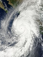
Hurricane Gloria was a powerful hurricane that caused significant damage along the east coast of the United States and in Atlantic Canada during the 1985 Atlantic hurricane season. It was the first significant tropical cyclone to strike the northeastern United States since Hurricane Agnes in 1972 and the first major storm to affect New York City and Long Island directly since Hurricane Donna in 1960. Gloria was a Cape Verde hurricane originating from a tropical wave on September 16 in the eastern Atlantic Ocean. After remaining a weak tropical cyclone for several days, Gloria intensified into a hurricane on September 22 north of the Lesser Antilles. During that time, the storm had moved generally westward, although it turned to the northwest due to a weakening of the ridge. Gloria quickly intensified on September 24, and the next day reached peak winds of 145 mph (233 km/h). The hurricane weakened before striking the Outer Banks of North Carolina on September 27. Later that day, Gloria made two subsequent landfalls on Long Island and across the coastline of western Connecticut, before becoming extratropical on September 28 over New England. The remnants moved through Atlantic Canada and went on to impact Western Europe, eventually dissipating on October 4.
Before Gloria made landfall, the National Hurricane Center issued hurricane warnings at some point for the East Coast of the United States from South Carolina to Maine. Hundreds of thousands of people evacuated, and the hurricane was described as the "storm of the century." In general, Gloria's strongest winds remained east of the center, which largely spared locations from North Carolina to New Jersey, and the passage at low tide reduced storm surge. Hurricane-force winds and gusts affected much of the path, which knocked down trees and power lines. This left over 4 million people without power, causing the worst power outage in Connecticut history related to a natural disaster. Fallen trees caused six of the storm's fourteen deaths. (Full article...)
The central dense overcast, or CDO, of a tropical cyclone or strong subtropical cyclone is the large central area of thunderstorms surrounding its circulation center, caused by the formation of its eyewall. It can be round, angular, oval, or irregular in shape. This feature shows up in tropical cyclones of tropical storm or hurricane strength. How far the center is embedded within the CDO, and the temperature difference between the cloud tops within the CDO and the cyclone's eye, can help determine a tropical cyclone's intensity with the Dvorak technique. Locating the center within the CDO can be a problem with strong tropical storms and minimal hurricanes as its location can be obscured by the CDO's high cloud canopy. This center location problem can be resolved through the use of microwave satellite imagery.
After a cyclone strengthens to around hurricane intensity, an eye appears at the center of the CDO, defining its center of low pressure and its cyclonic wind field. Tropical cyclones with changing intensity have more lightning within their CDO than steady state storms. Tracking cloud features within the CDO using frequently updated satellite imagery can also be used to determine a cyclone's intensity. The highest maximum sustained winds within a tropical cyclone, as well as its heaviest rainfall, are usually located under the coldest cloud tops in the CDO.
(Full article...)

The 2003 Pacific hurricane season was the first season to feature no major hurricanes (storms of Category 3 intensity or higher on the Saffir–Simpson hurricane wind scale) since 1977. The season officially began on May 15, 2003 in the Eastern North Pacific (east of 140°W), and on June 1 in the Central (between 140°W and the International Date Line); both ended on November 30. These dates, adopted by convention, historically describe the period in each year when most tropical cyclogenesis occurs in these regions of the Pacific. The season featured 16 tropical storms, 7 of which intensified into hurricanes, which was then considered an average season. Damage across the basin reached US$129 million, and 23 people were killed by the storms.
Despite the overall lack of activity, the season produced an unusually large number of tropical cyclones that affected Mexico, with eight tropical cyclones making landfall on either side of Mexico, which was the second highest on record. Tropical Storm Carlos struck Oaxaca in late June, resulting in nine fatalities. In late August, Hurricane Ignacio struck the Baja California Peninsula, killing four people and inflicting US$21 million in damage. In September, Hurricane Marty affected the same areas as Ignacio, and was responsible for 12 casualties and US$100 million in damage, making Marty the costliest and deadliest storm of the season. In October, Hurricanes Olaf and Nora struck western Mexico as tropical depressions, causing slight damage and one casualty. (Full article...)
Italicized basins are unofficial.
- North Atlantic (2024)
- No active systems
- East and Central Pacific (2024)
- No active systems
- North Indian Ocean (2024)
- No active systems
- Mediterranean (2024–25)
- No active systems
- South-West Indian Ocean (2024–25)
- No active systems
- Australian region (2024–25)
- No active systems
- South Pacific (2024–25)
- No active systems
- South Atlantic (2024–25)
- No active systems
Last updated: 08:01, 6 September 2024 (UTC)

September 7
- 1991 - Hurricane Claudette reaches peak intensity as a Category 4 major hurricane with winds of 215 km/h (130 mph) and a minimum pressure of 944 hPa.
- 2004 - Hurricane Ivan (pictured) passed just to the north of Grenada causing over $800 million of damage. Ivan caused a total of over $16 billion of damage, mostly in the United States.

September 8
- 1900 - The 1900 Galveston hurricane (track pictured) struck Galveston, Texas, with winds in excess of 240 km/h (150 mph). The hurricane is the deadliest in the history of the United States and killed over 8,000 people.
- 1987 - Typhoon Gerald reaches peak intensity with 10-minute winds of 150 km/h (90 mph) and a minimum pressure of 950 hPa before making landfall in Taiwan which killed 127 people in total.

September 9
- 1965 - Hurricane Betsy made landfall in southeast Louisiana as a Category 3 hurricane, flooding much of New Orleans. Betsy caused over $1 billion of damages.
- 1985 - Hurricane Rick (pictured) becomes a Category 4 major hurricane with winds of 230 km/h (145 mph) and a pressure of 951 hPa.
- 2015 - Tropical Storm Etau makes landfall in Honshu bringing extreme flooding with damages nearly up to $100 million.


- …that the Joint Typhoon Warning Center considers that Typhoon Vera (pictured) of 1986 is actually two distinct systems, formed from two separated low-level circulations?
- …that Cyclone Freddy (track pictured) in 2023 was the longest-lasting tropical cyclone worldwide?
- …that Cyclone Raquel (track pictured) travelled between the Australian and South Pacific basins between the 2014–15 and 2015–16 seasons, spanning both seasons in both basins?
- …that Hurricane Otis (pictured) in 2023 was the first Pacific hurricane to make landfall at Category 5 intensity and surpassed Hurricane Patricia as the strongest landfalling Pacific hurricane on record?
-
-
The aftermath of Hurricane Katrina in Gulfport, Mississippi. Katrina was the costliest tropical cyclone in United States history. (from Effects of tropical cyclones)
-
Aerial image of destroyed houses in Tacloban, following Typhoon Haiyan (from Effects of tropical cyclones)
-
The number of $1 billion Atlantic hurricanes almost doubled from the 1980s to the 2010s, and inflation-adjusted costs have increased more than elevenfold. The increases have been attributed to climate change and to greater numbers of people moving to coastal areas. (from Effects of tropical cyclones)
-
Flooding in Port Arthur, Texas caused by Hurricane Harvey. Harvey was the wettest and second-costliest tropical cyclone in United States history. (from Effects of tropical cyclones)
-
All but the most expensive bottles of water were sold out at this Publix supermarket before Hurricane Irma; in the week preceding the storm, water sold out soon after shipments arrived (from Tropical cyclone preparedness)
-
Radar image of Hurricane Erika making landfall over Northeastern Mexico (from Tropical cyclone observation)
-
Broken concrete utility pole in Puerto Rico after Hurricane Maria in 2017, which ranks fourth in costliest US tropical cyclones. (from Effects of tropical cyclones)
-
(from Cyclone)
-
Percentages of hurricane deaths in the United States from 1970 to 1999. (from Effects of tropical cyclones)
-
-
-
2017 Atlantic hurricane season summary map (from Cyclone)
-
Comparison between extratropical and tropical cyclones on surface analysis (from Cyclone)
-
Tropical cyclones form when the energy released by the condensation of moisture in rising air causes a positive feedback loop over warm ocean waters. (from Cyclone)
-
(from Cyclone)
-
(from Cyclone)
-
A fictitious synoptic chart of an extratropical cyclone affecting the UK and Ireland. The blue arrows between isobars indicate the direction of the wind, while the "L" symbol denotes the centre of the "low". Note the occluded, cold and warm frontal boundaries. (from Cyclone)
-
Surface weather map of the 1935 Labor Day hurricane moving up the west coast of Florida (from Tropical cyclone observation)
-
(from Cyclone)
-
An extratropical cyclone near Iceland (from Cyclone)
-
The initial extratropical low-pressure area forms at the location of the red dot on the image. It is usually perpendicular (at a right angle to) the leaf-like cloud formation seen on satellite during the early stage of cyclogenesis. The location of the axis of the upper level jet stream is in light blue. (from Cyclone)
-
Hurricane response involves working in hazardous conditions, including contamination and electrocution hazards from floodwater.
-
Chart with concurrent information for Hurricane Arlene and Tropical Storm Bret logged and plotted (from Tropical cyclone preparedness)
-
Cyclone on Mars, imaged by the Hubble Space Telescope (from Cyclone)
-
A polar low over the Sea of Japan in December 2009 (from Cyclone)
-
The dangerous semicircle is the upper-right corner, with the arrow marking the direction of motion of a Northern Hemisphere storm. Note that typhoons, etc. are asymmetrical, and semicircle is a convenient misnomer. (from Effects of tropical cyclones)
-
Hurricane Isabel (2003)'s effect on the North Carolina Outer Banks (from Effects of tropical cyclones)
-
(from Cyclone)
-
-
-
An example of a chart for Matthew showing its five-day forecast track (from Tropical cyclone preparedness)
-
Personnel and equipment from the National Guard of the United States en route to Hurricane Florence response efforts in 2018
-
Hurricane Catarina, a rare South Atlantic tropical cyclone viewed from the International Space Station on March 26, 2004 (from Cyclone)


WikiProject Tropical cyclones is the central point of coordination for Wikipedia's coverage of tropical cyclones. Feel free to help!
WikiProject Weather is the main center point of coordination for Wikipedia's coverage of meteorology in general, and the parent project of WikiProject Tropical cyclones. Three other branches of WikiProject Weather in particular share significant overlaps with WikiProject Tropical cyclones:
- The Non-tropical storms task force coordinates most of Wikipedia's coverage on extratropical cyclones, which tropical cyclones often transition into near the end of their lifespan.
- The Floods task force takes on the scope of flooding events all over the world, with rainfall from tropical cyclones a significant factor in many of them.
- WikiProject Severe weather documents the effects of extreme weather such as tornadoes, which landfalling tropical cyclones can produce.
 |
Here are some tasks awaiting attention:
|
The following Wikimedia Foundation sister projects provide more on this subject:
-
Commons
Free media repository -
Wikibooks
Free textbooks and manuals -
Wikidata
Free knowledge base -
Wikinews
Free-content news -
Wikiquote
Collection of quotations -
Wikisource
Free-content library -
Wikiversity
Free learning tools -
Wikivoyage
Free travel guide -
Wiktionary
Dictionary and thesaurus


