Salesches
Appearance
Salesches | |
|---|---|
 The church in Salesches | |
| Coordinates: 50°12′14″N 3°35′18″E / 50.2039°N 3.5883°E | |
| Country | France |
| Region | Hauts-de-France |
| Department | Nord |
| Arrondissement | Avesnes-sur-Helpe |
| Canton | Avesnes-sur-Helpe |
| Intercommunality | CC Pays de Mormal |
| Government | |
| • Mayor (2020–2026) | Patrick Piana[1] |
Area 1 | 4.58 km2 (1.77 sq mi) |
| Population (2021)[2] | 329 |
| • Density | 72/km2 (190/sq mi) |
| Time zone | UTC+01:00 (CET) |
| • Summer (DST) | UTC+02:00 (CEST) |
| INSEE/Postal code | 59549 /59218 |
| Elevation | 85–138 m (279–453 ft) (avg. 130 m or 430 ft) |
| 1 French Land Register data, which excludes lakes, ponds, glaciers > 1 km2 (0.386 sq mi or 247 acres) and river estuaries. | |
Salesches (French pronunciation: [salɛʃ]) is a commune in the Nord department in northern France.[3] It is located 6 km south of Le Quesnoy.
History
[edit]The village dates back to 1131, when it was recorded as part of the property of the Abbey of Maroilles, later passing to the bishop of Cambrai. Most of the local economy was agricultural, with two water mills to make flour.[4]
Churches
[edit]The parish church is dedicated to Saint-Quinibert. In addition to the parish church, there is a small chapel, Chapelle Notre Dame des Prés, located alongside the Saint-Georges stream, accessible by foot from the rue de Viterlan.
Heraldry
[edit] |
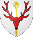
The arms of Salesches are blazoned : Argent, a stag's massacre gules surmounting a crozier palewise Or. (Marbaix, Maroilles, Noyelles-sur-Sambre, and Salesches use the same arms.)
|
See also
[edit]References
[edit]- ^ "Répertoire national des élus: les maires". data.gouv.fr, Plateforme ouverte des données publiques françaises (in French). 9 August 2021.
- ^ "Populations légales 2021" (in French). The National Institute of Statistics and Economic Studies. 28 December 2023.
- ^ INSEE commune file
- ^ "Salesches, village de l'Avesnois (fr.)". Villages de l'Avesnois. Retrieved 18 August 2021.
Wikimedia Commons has media related to Salesches.


