Avalonia: Difference between revisions
Fama Clamosa (talk | contribs) m →Development: wikify |
Fama Clamosa (talk | contribs) →Consequences: section renamed |
||
| Line 25: | Line 25: | ||
[[Geology of the Iberian Peninsula|Iberia]] was later rotated away again as the African part of Gondwana strike-slipped past it. This last movement caused the [[Alpine orogeny]] including the raising of the [[Pyrenees]] during the [[Miocene]] and [[Pliocene]]. As a result of this, part of Avalonia is now to be found on each side of the [[Straits of Gibraltar]].<ref>{{Harvnb|Golonka|2002|loc=Fig. 38}}</ref> |
[[Geology of the Iberian Peninsula|Iberia]] was later rotated away again as the African part of Gondwana strike-slipped past it. This last movement caused the [[Alpine orogeny]] including the raising of the [[Pyrenees]] during the [[Miocene]] and [[Pliocene]]. As a result of this, part of Avalonia is now to be found on each side of the [[Straits of Gibraltar]].<ref>{{Harvnb|Golonka|2002|loc=Fig. 38}}</ref> |
||
== |
== Extent == |
||
[[File:Avalonia in Europe.jpg|thumb|right|250px|This map shows the positions of the rocks of Avalonia remaining in Europe. The notes on it indicate the part which collided with Baltica in the upper Ordovician and that which collided with Laurentia in the Silurian. The parts of Avalonia now in Iberia and Morocco were carried there by rotation of Iberia during the subsequent collision with Gondwana followed by separation. These rocks are by no means all at the modern surface.]] |
[[File:Avalonia in Europe.jpg|thumb|right|250px|This map shows the positions of the rocks of Avalonia remaining in Europe. The notes on it indicate the part which collided with Baltica in the upper Ordovician and that which collided with Laurentia in the Silurian. The parts of Avalonia now in Iberia and Morocco were carried there by rotation of Iberia during the subsequent collision with Gondwana followed by separation. These rocks are by no means all at the modern surface.]] |
||
Revision as of 09:07, 22 July 2022

US: United States; CT: Connecticut; MA: Massachusetts; NH: New Hampshire; ME: Maine; RI: Rhode-Island
CA: Canada; NB: New Brunswick; NFL: Newfoundland; NS: Nova-Scotia; PE: Prince Edward Island
Europe: IE: Ireland; UK: United Kingdom; FR: France; BE: Belgium; NL: Netherlands; DE: Germany; PL: Poland
Avalonia was a microcontinent in the Paleozoic era. Crustal fragments of this former microcontinent underlie south-west Great Britain, southern Ireland, and the eastern coast of North America. It is the source of many of the older rocks of Western Europe, Atlantic Canada, and parts of the coastal United States. Avalonia is named for the Avalon Peninsula in Newfoundland.
The North American terranes of Ganderia and Carolinia are sometimes grouped with Avalonia, jointly called "Greater Avalonia", because they were transferred together across the Iapetus Ocean.[1]
Avalonia developed as a volcanic arc on the northern margin of Gondwana. It eventually rifted off, becoming a drifting microcontinent. The Rheic Ocean formed behind it, and the Iapetus Ocean shrank in front. It collided with the continents Baltica, then Laurentia, and finally with Gondwana, ending up in the interior of Pangea. When Pangea broke up, Avalonia's remains were divided by the rift which became the Atlantic Ocean.
Development


The basement of Avalonia is poorly known, but, based on isotopic analysis's, proto-Avalonia most likely evolved together with Carolina ca. 800 Ma from volcanic arcs far offshore from the supercontinent Rodinia, most likely outboard continental terranes of more obvious West African affinities, such as Cadomia and Iberia. Ca. 650 Ma the Avalonian belt collided with Gondwana.[2][3]
During the Precambrian-Cambrian transition, Avalonia was located in a cool-water environment and even underwent a glaciation. The Moroccan Anti-Atlas range in West Gondwana was, in contrast, characterised by evaporites, evidence of desiccation, and had thrombolites. Avalonia and Gondwana must therefore have been located far from each other during this period. The two did, however, share a geological history from later in the early Cambrian until the mid-Orodovician.[4]
Subduction evolved along the shores of Gondwana, which caused Avalonia to rift away and begin its northbound journey towards Baltica during late Cambrian and Early Ordovician. The Rheic Ocean opened behind the Avalonian microcontinents.[5] This independent movement of Avalonia started from a latitude of about 60° South.[6] The eastern end of Avalonia collided with Baltica, which occupied the latitudes from about 30°S to 55°S, completing the closure of the Tornquist Sea at the end of the Ordovician and during the Early Silurian.[7]
In the late Silurian and lower Devonian, the combined Baltica and Avalonia collided progressively, with Laurentia, beginning with the long extremity of Avalonia which is now attached to North America. The result of this was the formation of Euramerica. At the completion of this stage, the site of Britain was at 30°S and Nova Scotia at about 45°S. This collision is represented by the Caledonian folding or in North America as an early phase in the Acadian orogeny.[8]
In the Carboniferous, the new continent and another terrane, Armorica which included Iberia, drifted in from Gondwana, trapping Avalonia between it and the continent so adding Iberia/Armorica to Euramerica.[9] This was followed up by the arrival of Gondwana. The effects of these collisions are seen in Europe as the Variscan folding. In North America it shows as later phases of the Acadian orogeny. This was happening at around the Equator during the later Carboniferous, forming Pangaea with Avalonia near its centre but partially flooded by shallow sea.[10]
In the Jurassic, Pangaea split into Laurasia and Gondwana, with Avalonia as part of Laurasia.[11] In the Cretaceous, Laurasia broke up into North America and Eurasia with Avalonia split between them.[12]
Iberia was later rotated away again as the African part of Gondwana strike-slipped past it. This last movement caused the Alpine orogeny including the raising of the Pyrenees during the Miocene and Pliocene. As a result of this, part of Avalonia is now to be found on each side of the Straits of Gibraltar.[13]
Extent
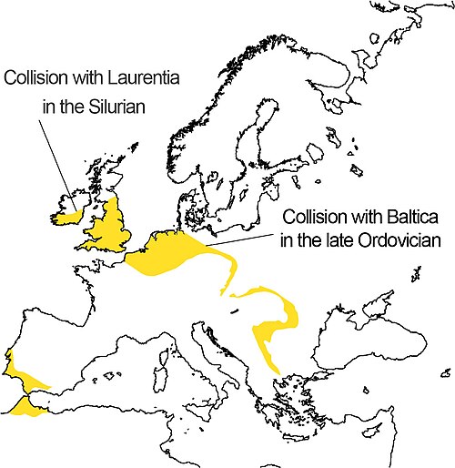
The Avalonian part of Great Britain almost exactly coincides with England and Wales. Elsewhere in Europe, parts of Avalonia are found in the Ardennes of Belgium and north-eastern France, north Germany, north-western Poland, south-eastern Ireland, and the south-western edge of the Iberian Peninsula.
Part of the British-Belgian section formed an island in the Carboniferous, affecting the disposition of coalfields; this is known by names such as the 'London-Brabant Island'. Its bulk had an effect on the geological structure between the Ardennes and the English Midlands by influencing the subsequent crustal folding resulting from the Variscan collision.
In Canada, Avalonia comprises the Avalon Peninsula of southeast Newfoundland, southern New Brunswick, part of Nova Scotia, and Prince Edward Island. In the United States, Avalonia consists of northern coastal Maine, all of Rhode Island, and other sections of coastal New England.
See also
References
Notes
- ^ Keppie & Keppie 2014, Introduction, p. 6
- ^ Murphy et al. 2001, 800-625 Ma, p. 46
- ^ McNamara et al. 2001, Abstract
- ^ Landing, Westrop & Bowring 2013, Introduction
- ^ Golonka et al. 2009, The Rifting of Avalonian terranes
- ^ Golonka 2002, Fig. 6
- ^ Golonka 2002, Fig. 7
- ^ Golonka 2002, Fig. 8
- ^ Golonka 2002, Fig. 16
- ^ Golonka 2002, Fig. 17
- ^ Golonka 2002, Fig. 26
- ^ Golonka 2002, Fig. 31
- ^ Golonka 2002, Fig. 38
Sources
- Golonka, J. (2002). "Plate-tectonic maps of the Phanerozoic" (PDF). SEPM Special Publications. 72 (72): 21–75. Retrieved 15 July 2022.
- Golonka, J.; Krobicki, M.; Poprawa, P.; Paul, Z.; Khudoley, A. (2009). "Early Paleozoic evolution of the peri-Gondwana plates". Geologia. 35 (2/1): 339–343. Retrieved 18 April 2022.
- Keppie, J.; Keppie, D. (2014). "Ediacaran–Middle Paleozoic oceanic voyage of Avalonia from Baltica via Gondwana to Laurentia: Paleomagnetic, faunal and geological constraints" (PDF). Geoscience Canada: Journal of the Geological Association of Canada/Geoscience Canada: journal de l’Association Géologique du Canada. 41 (1): 5–18. Retrieved 21 July 2022.
- Landing, E. D.; Westrop, S. R.; Bowring, S. A. (2013). "Reconstructing the Avalonia palaeocontinent in the Cambrian: A 519 Ma caliche in South Wales and transcontinental middle Terreneuvian sandstones" (PDF). Geological Magazine. 150 (6): 1022–1046. doi:10.1017/S0016756813000228. Retrieved 10 July 2022.
- McNamara, A. K.; Mac Niocaill, C.; van der Pluijm, B. A.; Van der Voo, R. (2001). "West African proximity of the Avalon terrane in the latest Precambrian" (PDF). Geological Society of America Bulletin. 113 (9): 1161–1170. Bibcode:2001GSAB..113.1161M. doi:10.1130/0016-7606(2001)113<1161:WAPOTA>2.0.CO;2. Retrieved 16 August 2018.
- Murphy, J. B.; Pisarevsky, S. A.; Nance, R. D.; Keppie, J. D. (2001). Jessell, M. J. (ed.). "Animated history of Avalonia in Neoproterozoic - Early Proterozoic". General Contributions. Journal of the Virtual Explorer. 3: 45–58. doi:10.3809/jvirtex.2001.00026. Retrieved 28 November 2015.
External links

Continents of Earth | ||||||||
|---|---|---|---|---|---|---|---|---|
| ||||||||
| ||||||||


- Historical continents
- Ordovician geology
- Paleozoic Europe
- Paleozoic North America
- Geology of England
- Geology of Nova Scotia
- Geology of New Brunswick
- Geology of Newfoundland and Labrador
- Geology of Wales
- Terranes
- Ordovician England
- Ordovician Nova Scotia
- Ordovician New Brunswick
- Ordovician Newfoundland and Labrador