World History/Maps
Appearance
Maps | Resources | Contributors' Corner
Welcome to the World History Project's collection of online maps, which have been made especially for this project. Below you will find them conveniently organized into historical periods, trying to keep at least some semblance of order. If you wish to contribute, please go here.
Ancient History
[edit | edit source]-
Sumer and the Akkadian Empire.
-
East Hemisphere in 500 BC (height of the Persian Empire).
-
Persian Empire 490 BC.
-
Empire of Alexander the Great.
-
East Hemisphere in 323 BC (before Alexander's death).
The Classical Age
[edit | edit source]-
The Roman Republic at 44BC
-
The Roman Empire in 60 AD
The Medieval World
[edit | edit source]-
The Byzantine Empire at its height
-
Europe 1430
The Colonial Age
[edit | edit source]-
The Ottoman Empire at its height in 1683.
-
Colonial possessions in 1674
-
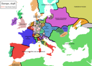
Europe in 1648
Colonial Empires
[edit | edit source]-
The Dutch Empire and its possessions at different times in history.
-
The British Empire and its possessions at different times in history.
-
The Italian Empire in 1940.
-
The Portuguese Empire and its possessions at different times in history.
-
The French Empire and its possessions at different times in history.
-
The Swedish Empire and its possessions at different times in history.
-
The Belgian Empire in 1925.
-
The German Colonial Empire and additional colonial activity in the Americas.
-
The Danish Empire and its possessions at different times in history.
-
The Spanish Empire and its possessions at different times in history.
-
The Japanese Empire in 1942.
-
World Colonization in 1920.
The Modern Era
[edit | edit source]-
Dutch expansion in the East Indies.
-
Alliances prior to WWI.
-
Central Powers gains in WWI.
-
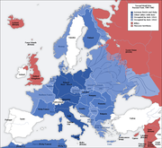
Europe under German and Italian Occupation during WWII.
Contempory maps
[edit | edit source]Included for use as a comparison with historic maps.
-
Political world map from the CIA World Factbook
-
Composite photo of Earth without clouds as of 2002 by NASA.
-
Composite image of the Earth at Night in 2016 by NASA. Lights are evidence of high human populations.
-
Pacific oriented map, more commonly used in certain countries.
-
A "South Up" map, useful for considering the world from a different perspective.
-
Countries by Human Development Index as of 2021.
-
Estimated Life Expectancy by Country in 2008 according to the CIA World Factbook
Religions
[edit | edit source]-
Largest religious group by country
-
Map of Abrahamic religions by country
-
Map of Islam by country
-
Map of Christianity by country
-
Map of Catholic population around the world
-
Hinduism around the world
-
Map of Buddhism population by country
Languages
[edit | edit source]-
Language groups.
-
English Language around the world.
-
The Dutch language around the world.
-
The French language around the world.
-
The Portuguese language around the world.
-
Map of the Russian language around the world.
-
Map of the Arabic language around the world
-
Map of the Mandarin language around the world.


