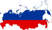
File:Flag-map of Russia-edit.svg
From Wikimedia Commons, the free media repository
Jump to navigation
Jump to search

Size of this PNG preview of this SVG file: 800 × 465 pixels. Other resolutions: 320 × 186 pixels | 640 × 372 pixels | 1,024 × 595 pixels | 1,280 × 744 pixels | 2,560 × 1,488 pixels | 1,039 × 604 pixels.
Original file (SVG file, nominally 1,039 × 604 pixels, file size: 51 KB)
File information
Structured data
Captions
Captions
Add a one-line explanation of what this file represents
| DescriptionFlag-map of Russia-edit.svg |
English: Russian Flag-Map with transparent background
Русский: Флаг-карта России |
|||
| Date | ||||
| Source | Own work | |||
| Author |
|
|||
| Permission (Reusing this file) |
|
|||
| Other versions |
Derivative works of this file: COA-map of Russia.png
|
File history
Click on a date/time to view the file as it appeared at that time.
| Date/Time | Thumbnail | Dimensions | User | Comment | |
|---|---|---|---|---|---|
| current | 16:22, 27 October 2018 | 1,039 × 604 (51 KB) | HansonPhan (talk | contribs) | Reverted to version as of 00:11, 20 May 2012 (UTC) | |
| 10:31, 18 August 2015 | 1,039 × 604 (51 KB) | Illegitimate Barrister (talk | contribs) | wrong colors. to avoid duplicate, changed to 1992 colors. | ||
| 01:30, 4 November 2014 | 1,039 × 604 (51 KB) | Fry1989 (talk | contribs) | Reverted to version as of 00:11, 20 May 2012 | ||
| 00:23, 4 November 2014 | 1,077 × 602 (40 KB) | Knyaz-1988 (talk | contribs) | New version | ||
| 00:23, 4 November 2014 | 1,622 × 960 (38 KB) | Knyaz-1988 (talk | contribs) | Reverted to version as of 12:55, 10 December 2007 | ||
| 00:11, 20 May 2012 | 1,039 × 604 (51 KB) | Fry1989 (talk | contribs) | fix map, colours from Commons file | ||
| 12:55, 10 December 2007 | 1,622 × 960 (38 KB) | Pinpin (talk | contribs) | {{Information |Description= * {{en|Russian Flag-Map with transparent background}} |Source=own-work |Date= 2007-12-10 |Author= * en.wiki: Aivazovsky * commons: Aivazovsky * based on [[:Image:BlankMap-RussiaDistr |
You cannot overwrite this file.
File usage on Commons
The following 4 pages use this file:
File usage on other wikis
The following other wikis use this file:
- Usage on bg.wikipedia.org
- Usage on de.wikipedia.org
- Grenze zwischen Estland und Russland
- Grenze zwischen Russland und der Ukraine
- Grenze zwischen Nordkorea und Russland
- Grenze zwischen Litauen und Russland
- Grenze zwischen Polen und Russland
- Grenze zwischen Norwegen und Russland
- Vorlage:Navigationsleiste Grenzen Russlands
- Grenze zwischen der Volksrepublik China und Russland
- Grenze zwischen Finnland und Russland
- Grenze zwischen Belarus und Russland
- Grenze zwischen Aserbaidschan und Russland
- Grenze zwischen Kasachstan und Russland
- Usage on en.wikipedia.org
- Podkamennaya Tunguska
- Abakan (river)
- Palata (river)
- Łyna (river)
- Pregolya
- Kotorosl
- Vetluga (river)
- Samara (Volga)
- Tobol
- Istra (river)
- Upa (river)
- Kazanka (river)
- Tom (river)
- Vasyugan
- Tura (river)
- Voronezh (river)
- Klyazma
- Paatsjoki
- Kosovskoye Lake
- Kosovka (river)
- Angrapa
- Ugra (Oka)
- Om (river)
- Sviyaga
- Unzha
- Sylva (river)
- Ufa (river)
- Vyatka (river)
- Vishera (Komi Republic)
- Šešupė
- Sal (Russia)
- Cheptsa
- Biya (river)
- Katun (river)
View more global usage of this file.
Metadata
This file contains additional information such as Exif metadata which may have been added by the digital camera, scanner, or software program used to create or digitize it. If the file has been modified from its original state, some details such as the timestamp may not fully reflect those of the original file. The timestamp is only as accurate as the clock in the camera, and it may be completely wrong.
| Width | 1038.601 |
|---|---|
| Height | 604.44385 |

