Category:St Ives, Cornwall
Jump to navigation
Jump to search
seaside town, civil parish and port in Cornwall, England 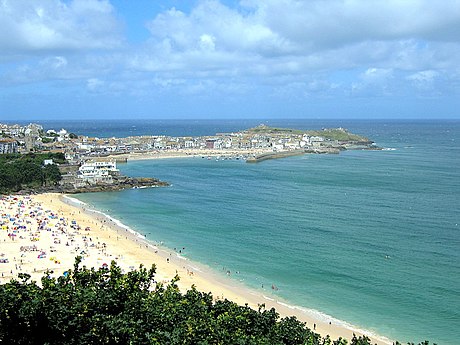 | |||||
| Upload media | |||||
| Instance of | |||||
|---|---|---|---|---|---|
| Location | Cornwall, South West England, England | ||||
| Population |
| ||||
| Area |
| ||||
| Different from | |||||
| official website | |||||
 | |||||

Brezhoneg: Porth Ia ( LFE: [ˌpɔrθ 'i:a], e saozneg: St. Ives) a zo ur gêr a Gernev-Veur e rannbarzh Pennwydh. E 2001 e oa 11.165 a dud o chom eno.
Català: Saint Ives, normalment denominat amb la forma abreujada St Ives (en còrnic Porth Ia), és una ciutat costanera del districte de Penwith, a Cornualla (Anglaterra).
Deutsch: St Ives ( Kornisch Porth Ia [KK], Porth Ya [UCR]) ist eine Stadt im District Penwith der Grafschaft Cornwall in England und zählt 11.165 Einwohner (Stand: 2001). Der Name leitet sich von der kornischen Heiligen Ia ab.
English: St Ives is a seaside town, civil parish and port in Cornwall, England, United Kingdom. The town lies north of Penzance and west of Camborne on the coast of the Celtic Sea. In former times it was commercially dependent on fishing. The decline in fishing, however, caused a shift in commercial emphasis and the town is now primarily a holiday resort. St Ives was incorporated by Royal Charter in 1639. St Ives has become renowned for its number of artists. It was named best seaside town of 2007 by the Guardian newspaper.
Euskara: Saint Ives, ohikoena bere izen laburtuaz izendatzea izaten da: St Ives ( kornubieraz Porth Ia), Penwitheko kostaldeko herri bat da, Kornuallesen, (Ingalaterra).
Suomi: St Ives (Porth Ia korniksi) on satamakaupunki Lounais- Englannissa, Cornwallin kreivikunnan pohjoisrannikolla.
Italiano: St Ives (in lingua cornica Porth Ia) è un paese di 11.165 abitanti della Cornovaglia, in Inghilterra, che si affaccia sull'omonima baia, al largo della quale si trova l'isola di Godrevy Island.
日本語: セント・アイヴス(St Ives、 コーンウォール語では Porthia)はイギリス・コーンウォール州にある海辺の街である。コーンウォール半島の突端近くの北海岸にあり、ペンザンスの北で、カンボルンの西に当たる。かつては漁業や関連産業に依存した町だったが、漁業の衰退により観光業に重点を置くようになった。現在では陽光の穏やかなリゾートの街となっており、またサーフィンの街、芸術家のコロニーとしても知られる。
Kernowek: Porth Ia ( Sowsnek: St Ives) yw tre yn Kernow, Breten Veur. Wosa devedhyans an hyns-horn yn 1877, Porth Ia a dheuth ha bos kres tornyaseth ha trevesigeth lymnoryon. Yma trevesigeth lymnoryon ow turya omma bys hedhyw. Yn niveryans 2001, yth esa dhe Borth Ia poblans a 9,866 trigor.
Nederlands: St Ives ( Cornisch: Porth Ia) is een plaats in het Engelse graafschap Cornwall. De plaats telt 11.165 inwoners.
Norsk bokmål: St. Ives (Porth Ia på kornisk) er en kystby i Cornwall, England. Den ligger nord for Penzance og vest for Camborne. Den var tidligere avhengig av fiske, men er nå først og fremst et turistmål.
Ирон: Сент-Айвс у былгæрон сахар Корнуоллы хуссар-ныгуылæны
Polski: St Ives ( korn. Porth Ia) - miasto w Wielkiej Brytanii, w Kornwalii nad Oceanem Atlantyckim. Port rybacki i popularna miejscowość wypoczynkowa, uznana w roku 2007 przez czytelników Guardiana za najlepszą miejscowość nadmorską w Wielkiej Brytanii. Znany brytyjski ośrodek surfingu, ustępujący popularnością jedynie Newquay.
Română: St Ives ( Limba cornică: Porth Ia) este un oraş în comitatul Cornwall, regiunea South West, Anglia. Oraşul se află în districtul Penwith.
Русский: Сент-Айвс — прибрежный городок в Корнуолле (Великобритания), в прошлом — рыбацкая деревня. Назван в честь св. Ии Корневилльской. Здесь в VI веке высадились ирландские миссионеры - просветители Корнуолла, включая свв. Гермока и Бреаку. Сейчас Сент-Айвс специализируется на туризме.
Subcategories
This category has the following 25 subcategories, out of 25 total.
- Penbeagle (2 F)
A
B
- Barnoon Cemetery, St Ives (24 F)
C
- The Carracks, Cornwall (30 F)
- Carrick Du (28 F)
E
G
H
I
L
- Leach Pottery (35 F)
N
- Night in St Ives, Cornwall (4 F)
P
S
- Sports in St Ives, Cornwall (16 F)
T
V
Pages in category "St Ives, Cornwall"
This category contains only the following page.
Media in category "St Ives, Cornwall"
The following 200 files are in this category, out of 379 total.
(previous page) (next page)-
Ayr Field Play Park, St Ives Cornwall.jpg 4,672 × 3,104; 6.49 MB
-
Back streets of St Ives - geograph.org.uk - 6627035.jpg 1,577 × 1,168; 558 KB
-
Barns at Hellesveor - geograph.org.uk - 6627039.jpg 3,194 × 1,570; 1.3 MB
-
Black headed gull - geograph.org.uk - 3807301.jpg 1,024 × 680; 103 KB
-
Boat off Bamaluz Point - geograph.org.uk - 2505998.jpg 640 × 490; 269 KB
-
Brea Cove - geograph.org.uk - 2526514.jpg 640 × 427; 180 KB
-
Breaking waves, St Ives (2531066798).jpg 2,560 × 1,920; 1.98 MB
-
Bridge to 1 ^ 2. ~ twilight - panoramio.jpg 2,992 × 2,992; 3.56 MB
-
Burthallan Cliff - geograph.org.uk - 4875819.jpg 1,600 × 1,200; 415 KB
-
Burthallan Cliff and Clodgy Point - geograph.org.uk - 4875837.jpg 1,600 × 1,200; 367 KB
-
Carbis Valley - geograph.org.uk - 6651599.jpg 3,648 × 1,744; 1.41 MB
-
Carn Everis rocks,off "the Island" at St Ives - geograph.org.uk - 5702892.jpg 5,202 × 3,465; 5.1 MB
-
-
-
Christmas morning swim - geograph.org.uk - 6366101.jpg 1,600 × 967; 339 KB
-
Christmas Nativity, St Ives - geograph.org.uk - 3807293.jpg 1,024 × 680; 172 KB
-
Clock and barometer in St Ives (6617).jpg 4,288 × 2,848; 3 MB
-
Coast path above Trowan Cliff - geograph.org.uk - 1841595.jpg 640 × 480; 109 KB
-
Coast Path on Burthallan Cliff - geograph.org.uk - 4875801.jpg 1,600 × 1,200; 450 KB
-
Coast west of St Ives - geograph.org.uk - 2698936.jpg 640 × 427; 212 KB
-
Coastal footpath, Hellesveor Cliff - geograph.org.uk - 3465473.jpg 640 × 480; 136 KB
-
Coastal footpath, Trevalgan Cliff - geograph.org.uk - 5736932.jpg 640 × 480; 157 KB
-
Coastal footpath, Trowan Cliff - geograph.org.uk - 3467873.jpg 640 × 480; 124 KB
-
Coastal footpath, Trowan Cliff - geograph.org.uk - 5736279.jpg 640 × 480; 168 KB
-
Coastal footpath, Trowan Cliff - geograph.org.uk - 5736342.jpg 640 × 480; 169 KB
-
Coastal path on St Ives Head - geograph.org.uk - 6651555.jpg 5,120 × 2,448; 2.76 MB
-
Coastal path, Hellesveor Cliff - geograph.org.uk - 5736111.jpg 640 × 480; 156 KB
-
Coastpath Goes Inland A Little - geograph.org.uk - 34838.jpg 479 × 640; 139 KB
-
Colourful gateway - geograph.org.uk - 4743911.jpg 4,896 × 3,672; 6.34 MB
-
Colourful hedge on Church Lane - geograph.org.uk - 4743909.jpg 4,896 × 3,672; 6.93 MB
-
Communications mast in Steeple Woods, Carbis Bay - geograph.org.uk - 4877091.jpg 1,200 × 1,600; 212 KB
-
Cornish-palm.jpg 2,322 × 4,128; 1.78 MB
-
Cornwall , Coastal Scenery - geograph.org.uk - 4607508.jpg 4,288 × 2,848; 6.04 MB
-
Cornwall , Coastal Scenery - geograph.org.uk - 4607769.jpg 4,288 × 2,848; 6.94 MB
-
Cornwall , Coastal Scenery - geograph.org.uk - 4607919.jpg 4,288 × 2,848; 6.48 MB
-
Cornwall , Hor Point - geograph.org.uk - 4607776.jpg 4,288 × 2,848; 6.9 MB
-
Cornwall , Rocky Coastline - geograph.org.uk - 4607770.jpg 4,198 × 2,789; 7.82 MB
-
Cornwall 2007 (496588330).jpg 2,048 × 1,371; 452 KB
-
Cornwall 2007 (496625825).jpg 2,048 × 1,371; 602 KB
-
Cornwall 2011 (6097724591).jpg 4,032 × 3,024; 3.72 MB
-
Cornwall 2011 (6098268198).jpg 4,256 × 2,832; 1.67 MB
-
-
Crossing a small stream on Burthallan Cliff - geograph.org.uk - 4875827.jpg 1,600 × 1,200; 476 KB
-
Damp section on coastal path - geograph.org.uk - 5737076.jpg 640 × 480; 155 KB
-
Defences on the coast - geograph.org.uk - 6140925.jpg 5,472 × 3,648; 6.97 MB
-
Downlong Cottage Guest House, St Ives - geograph.org.uk - 6626845.jpg 2,455 × 2,349; 1.3 MB
-
Dunes and sands - geograph.org.uk - 4259065.jpg 800 × 451; 196 KB
-
Empty yard at Hellesveor - geograph.org.uk - 5736092.jpg 640 × 480; 129 KB
-
Entrance to Ayr Holiday Park, St Ives - geograph.org.uk - 6572011.jpg 1,024 × 768; 514 KB
-
Evening fisherman - St Ives - geograph.org.uk - 1820263.jpg 640 × 480; 107 KB
-
Exposed channel marker - geograph.org.uk - 5912442.jpg 4,032 × 3,024; 2 MB
-
Farm at Carbis Water - geograph.org.uk - 2513182.jpg 640 × 427; 216 KB
-
Farm machinery near Trowan - geograph.org.uk - 5741311.jpg 640 × 480; 154 KB
-
Ferns on the Coastal Path - geograph.org.uk - 6501868.jpg 847 × 1,024; 194 KB
-
Footbridge over railway line, Porthminster Point - geograph.org.uk - 3824522.jpg 1,536 × 1,152; 1.2 MB
-
Footpath at Pen Enys Point looking towards Carn Naun Point - panoramio.jpg 1,280 × 960; 2.03 MB
-
Footpath by West Cornwall Golf Course - geograph.org.uk - 5434812.jpg 640 × 480; 100 KB
-
Footpath crossing to the golf course - geograph.org.uk - 6140928.jpg 3,264 × 2,448; 2.66 MB
-
Ginko (Autumn). - panoramio.jpg 2,672 × 4,000; 4.7 MB
-
Girls just having fun - St Ives - geograph.org.uk - 5411297.jpg 640 × 480; 48 KB
-
Godrevy Island - geograph.org.uk - 6652032.jpg 4,851 × 3,126; 1.67 MB
-
Gorse on the cliff top on Trowan Cliff - geograph.org.uk - 1827519.jpg 640 × 480; 112 KB
-
Grassdunes - geograph.org.uk - 6501871.jpg 819 × 1,024; 286 KB
-
Green lane towards the sea - geograph.org.uk - 5736097.jpg 640 × 480; 144 KB
-
Gwinear-Gwithian , St Ives Scenery - geograph.org.uk - 6338436.jpg 6,000 × 4,000; 7.38 MB
-
Hair braiding and lobotomies here (6097722625).jpg 4,256 × 2,832; 1.4 MB
-
-
Hayle estuary - geograph.org.uk - 5749228.jpg 1,024 × 792; 144 KB
-
Hayle Estuary at Lelant - geograph.org.uk - 5600744.jpg 640 × 427; 221 KB
-
Headland Road, Carbis Bay, 1949 - geograph.org.uk - 6366632.jpg 1,280 × 845; 349 KB
-
Hedge overlooking St Ives - geograph.org.uk - 4065041.jpg 3,872 × 2,592; 5.87 MB
-
Hellesveor Cliff - geograph.org.uk - 5736105.jpg 640 × 480; 132 KB
-
Hellesveor Hor Point towards Pen Enys Point - panoramio.jpg 1,280 × 960; 2.06 MB
-
Hellesveor Methodist Chapel - geograph.org.uk - 6627029.jpg 3,307 × 1,565; 1.27 MB
-
Higher Tregenna School - geograph.org.uk - 2514810.jpg 640 × 426; 191 KB
-
Higher Tregenna School - geograph.org.uk - 2514811.jpg 640 × 427; 215 KB
-
Hobblers. ~ twilight - panoramio.jpg 2,736 × 3,648; 3.22 MB
-
Hor Point - geograph.org.uk - 3467894.jpg 640 × 480; 126 KB
-
Jury-rigged channel marker - geograph.org.uk - 5912450.jpg 4,032 × 3,024; 863 KB
-
Knill's Monument - geograph.org.uk - 6593241.jpg 480 × 640; 78 KB
-
-
Le Tour du monde-11-p369.jpg 1,407 × 1,839; 912 KB
-
Lighthouse on Smeaton's Pier - geograph.org.uk - 6416551.jpg 1,024 × 577; 132 KB
-
Live statue - geograph.org.uk - 4308513.jpg 531 × 800; 114 KB
-
Looking across Hayle Natural History Reserve - geograph.org.uk - 6621109.jpg 2,170 × 1,466; 617 KB
-
Looking towards Trevethoe - geograph.org.uk - 6651696.jpg 3,124 × 1,685; 1.37 MB
-
Lookout on the Island - geograph.org.uk - 5600740.jpg 640 × 427; 189 KB
-
Low tide - geograph.org.uk - 5532158.jpg 2,592 × 1,944; 2.05 MB
-
Marram covered dunes - geograph.org.uk - 4259063.jpg 800 × 452; 175 KB
-
-
National Coast Watch Station on St Ives Head - geograph.org.uk - 6651545.jpg 3,648 × 1,744; 2.07 MB
-
National Coast Watch Station on St Ives Head - geograph.org.uk - 6651549.jpg 3,501 × 1,673; 913 KB
-
-
Near Carbis Bay - geograph.org.uk - 6651633.jpg 3,181 × 1,731; 1.36 MB
-
New Pier. ~ . twilight. - panoramio.jpg 4,000 × 2,248; 2.26 MB
-
Old Milestone by the A3074, Carbis Bay - geograph.org.uk - 5623522.jpg 480 × 640; 169 KB
-
-
Old wall and fence, Pen Enys Point - geograph.org.uk - 5736739.jpg 640 × 480; 161 KB
-
Old Wayside Cross - geograph.org.uk - 6494894.jpg 642 × 960; 312 KB
-
-
On Hellesveor Cliff - geograph.org.uk - 3477243.jpg 640 × 480; 113 KB
-
Ordnance Survey 1GL Bolt - geograph.org.uk - 5293425.jpg 640 × 394; 124 KB
-
Ordnance Survey 1GL Bolt - geograph.org.uk - 5293435.jpg 640 × 381; 118 KB
-
Ordnance Survey 1GL Bolt - geograph.org.uk - 5293456.jpg 640 × 403; 125 KB
-
Ordnance Survey cut mark - geograph.org.uk - 3861177.jpg 1,632 × 1,224; 423 KB
-
Ordnance Survey cut mark - geograph.org.uk - 3861238.jpg 1,224 × 1,632; 903 KB
-
Ordnance Survey Cut Mark - geograph.org.uk - 5293429.jpg 640 × 387; 32 KB
-
Ordnance Survey Cut Mark - geograph.org.uk - 5293438.jpg 640 × 369; 89 KB
-
Ordnance Survey Cut Mark - geograph.org.uk - 5293443.jpg 640 × 472; 49 KB
-
Ordnance Survey Cut Mark - geograph.org.uk - 5293448.jpg 640 × 382; 101 KB
-
Ordnance Survey Cut Mark - geograph.org.uk - 5293464.jpg 640 × 411; 120 KB
-
Ordnance Survey Flush Bracket 11626 - geograph.org.uk - 5432331.jpg 4,000 × 3,000; 3.86 MB
-
-
OS benchmark - St Ives, Back Road West - geograph.org.uk - 4713227.jpg 857 × 1,142; 589 KB
-
OS benchmark - St Ives, Lifeboat Inn - geograph.org.uk - 4713208.jpg 857 × 1,142; 591 KB
-
OS benchmark - St Ives, St Brigid's Apartments - geograph.org.uk - 4713230.jpg 872 × 1,108; 417 KB
-
OS benchmark - St Ives,34 Fore Street - geograph.org.uk - 4713192.jpg 857 × 1,142; 572 KB
-
-
OS benchmark ^ bolt - St Ives, St Ia's church - geograph.org.uk - 4713197.jpg 857 × 1,142; 723 KB
-
OS flush bracket - Burthallan Trig Point - geograph.org.uk - 4713188.jpg 814 × 1,088; 557 KB
-
Out St Nicholas' window. - panoramio.jpg 2,992 × 2,992; 3.5 MB
-
Outcrop on Hellesveor Cliff - geograph.org.uk - 5736206.jpg 640 × 480; 136 KB
-
Outside the harbour wall - geograph.org.uk - 3206125.jpg 1,142 × 857; 228 KB
-
Paddleboarder off Westcotts Quay, St Ives - geograph.org.uk - 4058033.jpg 2,104 × 1,577; 711 KB
-
Palemon Best playpark, St Ives - May 2022.jpg 4,032 × 3,024; 4.04 MB
-
-
-
Path Down To St Ives - geograph.org.uk - 3061581.jpg 480 × 640; 116 KB
-
Path on Carn Everis - geograph.org.uk - 5600739.jpg 640 × 427; 191 KB
-
Path on Carrack Gladden - geograph.org.uk - 4064043.jpg 3,872 × 2,592; 5.1 MB
-
Path towards Pen Enys Point - geograph.org.uk - 5736773.jpg 640 × 480; 165 KB
-
Path up to St Nicholas's Chapel - geograph.org.uk - 4065460.jpg 3,872 × 2,592; 2.52 MB
-
Path upon to The Island - geograph.org.uk - 5600105.jpg 640 × 427; 209 KB
-
Pen Enys Point from Hor Point - geograph.org.uk - 6279428.jpg 1,024 × 768; 702 KB
-
Penhalwyn Trekking Centre - geograph.org.uk - 6651902.jpg 3,648 × 1,744; 1.92 MB
-
Penwith , Boat ^ Clodgy Point - geograph.org.uk - 2500898.jpg 4,254 × 2,798; 3.04 MB
-
Penwith , Boat ^ Coastline - geograph.org.uk - 2500832.jpg 4,288 × 2,848; 5.47 MB
-
Penwith , Coastline at Hayle - geograph.org.uk - 2501315.jpg 4,288 × 2,848; 4.48 MB
-
Penwith , Coastline ^ Boat - geograph.org.uk - 2500881.jpg 4,212 × 2,728; 3.4 MB
-
Penwith , Cornish Coastline - geograph.org.uk - 2500792.jpg 4,288 × 2,848; 5.27 MB
-
Penwith , Cornish Coastline - geograph.org.uk - 2501311.jpg 4,280 × 2,836; 3.98 MB
-
Penwith , Orange Sunset over Penwith - geograph.org.uk - 2501327.jpg 4,288 × 2,848; 3.87 MB
-
Penwith , South West Coastal Path - geograph.org.uk - 2501322.jpg 4,256 × 2,798; 4.01 MB
-
Penwith , South West Coastal Path - geograph.org.uk - 2501333.jpg 2,848 × 4,288; 5.24 MB
-
Penwith , South West Coastal Path - geograph.org.uk - 2501336.jpg 4,288 × 2,848; 5.69 MB
-
Penwith , South West Coastal Path - geograph.org.uk - 2501338.jpg 2,848 × 4,288; 5.95 MB
-
Photograph of a bench (OpenBenches 367).jpg 3,024 × 4,032; 5.4 MB
-
Pier at St Ives - geograph.org.uk - 5600109.jpg 640 × 427; 175 KB
-
Pier on St Ives Head - geograph.org.uk - 3824548.jpg 1,536 × 1,152; 1.18 MB
-
Polgassick Rock - geograph.org.uk - 5736753.jpg 640 × 480; 177 KB
-
Porthgwidden beach, St Ives - geograph.org.uk - 5702908.jpg 5,202 × 3,465; 5.4 MB
-
Porthmeor Beach - geograph.org.uk - 6651562.jpg 5,000 × 2,352; 2.31 MB
-
Porthmeor Beach seen from The Tate, St. Ives - geograph.org.uk - 6367915.jpg 2,000 × 1,343; 2.23 MB
-
Porthminster Beach - geograph.org.uk - 6627188.jpg 3,648 × 1,744; 2.41 MB
-
Porthminster Beach - geograph.org.uk - 6627192.jpg 3,648 × 1,744; 2.21 MB
-
Porthminster Beach - geograph.org.uk - 6627196.jpg 3,615 × 1,605; 965 KB
-
Post 13, Trevalgan Farm Trail - geograph.org.uk - 5736909.jpg 640 × 480; 144 KB
-
Post 14, Trevalgan Farm Trail - geograph.org.uk - 5736959.jpg 640 × 480; 160 KB
-
Private lane to Trevethoe House (geograph 7061771).jpg 1,632 × 1,224; 794 KB
-
Public gardens, Porthminster Beach - geograph.org.uk - 3824526.jpg 1,536 × 1,152; 1.07 MB
-
Railway above Porth Kidney Sands - geograph.org.uk - 6140933.jpg 5,119 × 3,242; 5.76 MB
-
Railway into St Ives - geograph.org.uk - 6651567.jpg 2,736 × 2,736; 4.08 MB
-
Railway leaving St Ives - geograph.org.uk - 6651578.jpg 3,136 × 1,635; 1.36 MB
-
Railway line near Lelant Saltings - geograph.org.uk - 6140921.jpg 4,761 × 3,174; 5.5 MB
-
Railway near Carbis Bay - geograph.org.uk - 6140935.jpg 5,110 × 3,407; 6.44 MB
-
Railway near Tredarvah - geograph.org.uk - 6140930.jpg 4,920 × 3,280; 6.4 MB
-
Reflections in the harbour St Ives - geograph.org.uk - 6267512.jpg 640 × 440; 87 KB
-
Richmond Park - geograph.org.uk - 6651618.jpg 2,899 × 1,579; 882 KB
-
RNLI on Porthminster Beach - geograph.org.uk - 6627012.jpg 2,399 × 1,290; 586 KB
-
Rock above Trowan Cliff - geograph.org.uk - 1843306.jpg 640 × 480; 98 KB
-
Rock outcrop, Trevalgan Cliff - geograph.org.uk - 3465523.jpg 640 × 480; 130 KB
-
Rocks and cliffs west of Carrick Du - geograph.org.uk - 4875423.jpg 1,200 × 1,600; 290 KB
-
Rocks on "The Island", St Ives, with tourist boat - geograph.org.uk - 4057993.jpg 3,648 × 2,736; 2.35 MB
-
Rocks on Burthallan Cliff (6671).jpg 4,288 × 2,848; 2.94 MB
-
Rocks on Hellesveor Cliff - geograph.org.uk - 5736240.jpg 640 × 480; 173 KB
-
Rocks on Trevalgan Cliff (6684).jpg 4,288 × 2,848; 3.04 MB
-
Rocks on Trevalgan Cliff (6685).jpg 4,288 × 2,848; 3 MB
-
Rocks on Trevalgan Cliff (6686).jpg 4,288 × 2,848; 3.01 MB
-
Rocks on Trevalgan Cliff (6687).jpg 4,288 × 2,848; 2.93 MB
-
Rocks, west side of Pen Enys Point - geograph.org.uk - 5736769.jpg 640 × 480; 176 KB
-
Rod the deckchair man (6097720721).jpg 4,256 × 2,832; 2.04 MB
-
Roofs of St Ives - geograph.org.uk - 4855597.jpg 640 × 479; 95 KB
-
Rope. ~ twilight - panoramio.jpg 4,000 × 2,248; 3.64 MB
-
Sand and slipway - geograph.org.uk - 6293818.jpg 800 × 600; 77 KB
-
Sea at the tip of The Island, St Ives - geograph.org.uk - 5702894.jpg 5,202 × 3,465; 5.61 MB
-
Seahorse. ~ twilight - panoramio.jpg 4,000 × 2,248; 3.84 MB
-
Seal west of St Ives Head (6665).jpg 4,288 × 2,848; 3.03 MB
-
Seal west of St Ives Head (6666).jpg 4,288 × 2,848; 3 MB
-
Shoppers and holiday makers mingle - geograph.org.uk - 3041310.jpg 1,024 × 768; 247 KB
-
Shore pool and pier - geograph.org.uk - 6293795.jpg 800 × 600; 96 KB
-
Signpost for footpath inland from South West Coast Path - geograph.org.uk - 4875792.jpg 1,600 × 1,200; 438 KB
-
Silage bales near Trowan - geograph.org.uk - 5741317.jpg 640 × 480; 128 KB
-
Sloop Inn From Harbour Beach St Ives - geograph.org.uk - 5212958.jpg 640 × 480; 68 KB
-
Small allotment by South West Coast Path - geograph.org.uk - 4875782.jpg 1,600 × 1,200; 450 KB
-
Small Pier St Ives - geograph.org.uk - 2249285.jpg 640 × 398; 78 KB
-
Small pier, St Ives - geograph.org.uk - 2110904.jpg 640 × 480; 80 KB
-
Smeaton Pier St Ives - geograph.org.uk - 5506093.jpg 5,152 × 3,864; 5.68 MB
-
Smeaton's Pier - geograph.org.uk - 6140949.jpg 5,472 × 3,648; 4.14 MB
-
Smeatons Pier - geograph.org.uk - 6416567.jpg 1,024 × 576; 94 KB
-
Smoking Woman - St Ives - May 2018.jpg 4,184 × 2,710; 3.75 MB


