Category:Millbrook, Cornwall
Jump to navigation
Jump to search
civil parish and village in Cornwall, England  | |||||
| Upload media | |||||
| Instance of | |||||
|---|---|---|---|---|---|
| Location | Cornwall, South West England, England | ||||
| Population |
| ||||
 | |||||
Brezhoneg: Rummad:Kêrioù Breizh-Veur
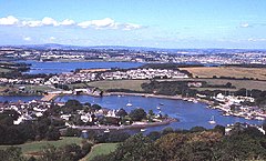
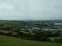
English: Millbrook is a village on the Rame Peninsula in south-east Cornwall, England, United Kingdom. The village is built around what was once a tidal creek, which is now dammed as a flood prevention measure and has become a well known birdwatching site. Millbrook is one of the largest villages in the county with a population of 2033 according to the 2001 Census.
Media in category "Millbrook, Cornwall"
The following 129 files are in this category, out of 129 total.
-
A view across the fields above Millbrook - geograph.org.uk - 3254358.jpg 640 × 427; 115 KB
-
All Saints Church Millbrook Cornwall.jpg 1,320 × 946; 560 KB
-
An overgrown footpath - geograph.org.uk - 371240.jpg 480 × 640; 97 KB
-
Anderton and Millbrook Lake - geograph.org.uk - 106806.jpg 640 × 387; 101 KB
-
B3247 approaching Millbrook - geograph.org.uk - 6152511.jpg 4,288 × 2,848; 1.77 MB
-
B3247 at St Andrews Street, Millbrook - geograph.org.uk - 6152516.jpg 3,334 × 2,150; 1.04 MB
-
B3247 near Millbrook - geograph.org.uk - 6152513.jpg 2,562 × 3,277; 1.35 MB
-
Blindwell Hill - geograph.org.uk - 6152664.jpg 3,937 × 2,628; 1.4 MB
-
Boat yard and reflections 2 - geograph.org.uk - 5764271.jpg 2,048 × 1,536; 559 KB
-
-
By the lane at Mendennick - geograph.org.uk - 6152755.jpg 3,209 × 1,964; 1.28 MB
-
Carved Stone - geograph.org.uk - 347762.jpg 480 × 640; 138 KB
-
Cattle near Millbrook - geograph.org.uk - 6152658.jpg 3,099 × 1,537; 466 KB
-
Chapel of rest at Millbrook cemetery - geograph.org.uk - 1609269.jpg 640 × 480; 63 KB
-
Coaster parked up at Southdown - geograph.org.uk - 347770.jpg 640 × 431; 83 KB
-
Down the hill to Mendennick - geograph.org.uk - 372925.jpg 640 × 480; 195 KB
-
Down to the Village - geograph.org.uk - 5764665.jpg 2,048 × 1,536; 1 MB
-
East Cornwall League Final, 2013-14.png 1,021 × 574; 1.32 MB
-
Entry to Millbrook car park - geograph.org.uk - 5873679.jpg 1,600 × 899; 743 KB
-
-
Field - Tree Line near Sango Point - geograph.org.uk - 341204.jpg 640 × 480; 55 KB
-
Field, Mendennick - geograph.org.uk - 6152742.jpg 4,288 × 2,848; 1.79 MB
-
Field, Mendennick - geograph.org.uk - 6152744.jpg 3,420 × 2,138; 1.21 MB
-
Field, Mendennick - geograph.org.uk - 6152747.jpg 3,142 × 1,925; 1.57 MB
-
Footpath next to the business park - geograph.org.uk - 5763918.jpg 640 × 480; 98 KB
-
Foss Point - geograph.org.uk - 6842967.jpg 1,024 × 768; 164 KB
-
Foss ^ Anderton from Maker - geograph.org.uk - 6233411.jpg 1,957 × 1,000; 1.72 MB
-
-
Freshwater Lake, Millbrook - geograph.org.uk - 36878.jpg 640 × 480; 91 KB
-
Greenhouses, Millbrook - geograph.org.uk - 6152507.jpg 4,176 × 2,598; 2 MB
-
-
Hillside above Millbrook - geograph.org.uk - 293336.jpg 640 × 426; 51 KB
-
Hillside above Millbrook - geograph.org.uk - 6151881.jpg 4,252 × 2,498; 2.73 MB
-
Hounster Farm - geograph.org.uk - 6152503.jpg 4,288 × 2,848; 1.53 MB
-
Houses at Millbrook - geograph.org.uk - 6152272.jpg 4,288 × 2,848; 2.48 MB
-
Insworke Barton - geograph.org.uk - 347759.jpg 640 × 437; 86 KB
-
Jenkins Park Sign.png 715 × 256; 366 KB
-
Jenkins Park, Millbrook.png 987 × 650; 771 KB
-
Jenkins Park.png 1,021 × 479; 826 KB
-
Junction near Millbrook - geograph.org.uk - 6152730.jpg 4,288 × 2,848; 2.73 MB
-
Junction on Southdown Road - geograph.org.uk - 6152479.jpg 4,288 × 2,467; 1.34 MB
-
Lake, Millbrook - geograph.org.uk - 6152267.jpg 4,288 × 2,848; 1.86 MB
-
Lake, Millbrook - geograph.org.uk - 6152297.jpg 4,288 × 2,848; 2.01 MB
-
Lane to Millbrook - geograph.org.uk - 6152821.jpg 2,831 × 3,687; 1.45 MB
-
Lane to Penhale - geograph.org.uk - 6152756.jpg 4,070 × 2,440; 1.37 MB
-
Lane to Penhale - geograph.org.uk - 6152936.jpg 2,848 × 3,590; 2.18 MB
-
Lane to St John - geograph.org.uk - 6152760.jpg 4,288 × 2,848; 2.62 MB
-
Low tide, Millbrook Lake - geograph.org.uk - 2222952.jpg 1,024 × 681; 204 KB
-
Maintenance on Yacht - geograph.org.uk - 345254.jpg 640 × 403; 94 KB
-
Marsh Wall - geograph.org.uk - 344104.jpg 640 × 438; 76 KB
-
Mendennick (geograph 6152737).jpg 4,231 × 2,807; 1.57 MB
-
Mendennick - geograph.org.uk - 372930.jpg 640 × 480; 124 KB
-
Millbrook (geograph 6152393).jpg 4,274 × 2,185; 771 KB
-
Millbrook - geograph.org.uk - 36815.jpg 640 × 480; 105 KB
-
Millbrook 1990.png 793 × 517; 745 KB
-
Millbrook boatyard - geograph.org.uk - 5766013.jpg 2,048 × 1,536; 921 KB
-
Millbrook burial ground - geograph.org.uk - 6151954.jpg 4,228 × 2,759; 2.22 MB
-
Millbrook Burial Ground - geograph.org.uk - 6151958.jpg 4,288 × 2,848; 2.56 MB
-
Millbrook business park - geograph.org.uk - 3254353.jpg 640 × 430; 48 KB
-
Millbrook Business Park - geograph.org.uk - 5763911.jpg 640 × 480; 81 KB
-
Millbrook Business Park - geograph.org.uk - 74987.jpg 640 × 410; 68 KB
-
Millbrook Freshwater Lake - geograph.org.uk - 5344720.jpg 1,600 × 1,067; 195 KB
-
Millbrook from Maker - geograph.org.uk - 6233398.jpg 1,393 × 1,000; 1.08 MB
-
Millbrook from Whitesand Bay Battery - geograph.org.uk - 917774.jpg 640 × 455; 182 KB
-
Millbrook Lake - geograph.org.uk - 1609280.jpg 640 × 480; 55 KB
-
Millbrook Lake - geograph.org.uk - 224162.jpg 640 × 427; 93 KB
-
Millbrook Lake - geograph.org.uk - 5643758.jpg 1,280 × 851; 498 KB
-
Millbrook Lake - geograph.org.uk - 5646941.jpg 1,280 × 851; 417 KB
-
Millbrook Lake - geograph.org.uk - 6842966.jpg 1,024 × 768; 116 KB
-
Millbrook Lake at low tide - geograph.org.uk - 1609275.jpg 640 × 480; 69 KB
-
Millbrook Lake Nov2015.jpg 1,789 × 1,180; 1.29 MB
-
Millbrook Lake, Cornwall, UK.jpg 4,000 × 3,000; 4.54 MB
-
Millbrook village from Maker heights - geograph.org.uk - 357263.jpg 640 × 480; 94 KB
-
Millbrook Village in the distance - geograph.org.uk - 3252226.jpg 640 × 430; 81 KB
-
Millbrook.jpg 1,280 × 960; 332 KB
-
Old Milestone by the B3247 in Millbrook - geograph.org.uk - 5623430.jpg 528 × 800; 172 KB
-
Outbuilding, Mendennick - geograph.org.uk - 6152739.jpg 2,842 × 4,023; 1.47 MB
-
Pete's Garage, Millbrook - geograph.org.uk - 6152383.jpg 4,270 × 2,441; 1.3 MB
-
Reclaimed Land Reclaimed by the Sea - geograph.org.uk - 347757.jpg 640 × 480; 85 KB
-
-
Sandway Beach at Low Tide, Cawsand Bay - geograph.org.uk - 403064.jpg 640 × 480; 115 KB
-
Sango Island - geograph.org.uk - 341175.jpg 640 × 480; 57 KB
-
Sheep on hill - geograph.org.uk - 5764662.jpg 2,048 × 1,536; 1.1 MB
-
Sheep pasture near Penhale - geograph.org.uk - 6152763.jpg 3,092 × 1,723; 792 KB
-
Sheep pasture near Penhale - geograph.org.uk - 6152766.jpg 3,260 × 2,043; 1.19 MB
-
Sheep pasture near Penhale - geograph.org.uk - 6152786.jpg 4,225 × 2,696; 1.74 MB
-
Shipwreck on beach - geograph.org.uk - 347768.jpg 640 × 480; 73 KB
-
Shoreline at Southdown near Millbrook - geograph.org.uk - 224164.jpg 640 × 427; 82 KB
-
Signage, Middle Lane, Millbrook - geograph.org.uk - 5873692.jpg 1,600 × 1,200; 904 KB
-
-
Southdown Marina from the water - geograph.org.uk - 340695.jpg 480 × 640; 59 KB
-
Southdown on the Insworke Peninsula - geograph.org.uk - 36899.jpg 640 × 367; 64 KB
-
Southdown Road - geograph.org.uk - 6152429.jpg 4,288 × 2,848; 2.52 MB
-
Southdown Road - geograph.org.uk - 6152436.jpg 4,288 × 2,848; 2.15 MB
-
Southdown Terrace - geograph.org.uk - 6152496.jpg 4,009 × 2,771; 1.24 MB
-
St Andrews Street meets the B3274, Millbrook - geograph.org.uk - 6152520.jpg 3,742 × 2,408; 1.54 MB
-
St Andrews Street, Millbrook - geograph.org.uk - 6152509.jpg 4,288 × 2,848; 1.74 MB
-
St Andrews Street, Millbrook - geograph.org.uk - 6152524.jpg 3,036 × 2,221; 749 KB
-
St John , Millbrook Scenery - geograph.org.uk - 6427312.jpg 6,000 × 4,000; 5.14 MB
-
St.John's Lake Mudflats - geograph.org.uk - 341220.jpg 640 × 480; 42 KB
-
St.John's Lake Mudflats - geograph.org.uk - 347760.jpg 640 × 480; 76 KB
-
Stream near Penhale - geograph.org.uk - 6152808.jpg 4,164 × 2,463; 1.6 MB
-
Street scene in Millbrook village - geograph.org.uk - 36883.jpg 640 × 480; 92 KB
-
The Mill Brook, Millbrook - geograph.org.uk - 5873681.jpg 1,600 × 1,200; 995 KB
-
The sun shines bright on a fresh day - geograph.org.uk - 347766.jpg 640 × 480; 75 KB
-
-
Tidal Creek - geograph.org.uk - 3254348.jpg 640 × 390; 75 KB
-
Tidal Creek at Anderton - geograph.org.uk - 2222956.jpg 1,024 × 681; 163 KB
-
To Insworke Barton - geograph.org.uk - 6152609.jpg 1,979 × 1,237; 419 KB
-
Towards Millbrook and Maker heights - geograph.org.uk - 359441.jpg 640 × 480; 144 KB
-
Track from Maker View Road - geograph.org.uk - 6152494.jpg 4,288 × 2,848; 1.91 MB
-
Track near Penhale - geograph.org.uk - 6152890.jpg 2,848 × 4,288; 2.47 MB
-
Trees reaching out for light - geograph.org.uk - 347769.jpg 640 × 451; 121 KB
-
Tregonhawke view to Plymouth - geograph.org.uk - 917757.jpg 640 × 480; 183 KB
-
Victorian postbox - geograph.org.uk - 1609303.jpg 640 × 480; 63 KB
-
View across beach to trees on skyline - geograph.org.uk - 347764.jpg 640 × 480; 103 KB
-
-
-
-
View from beach towards countryside - geograph.org.uk - 347763.jpg 640 × 480; 112 KB
-
-
View over Pottery Estate - geograph.org.uk - 6152592.jpg 2,354 × 1,343; 377 KB
-
View to Foss - geograph.org.uk - 2222948.jpg 1,024 × 681; 139 KB
-
-
Village hall, Millbrook - geograph.org.uk - 6152374.jpg 3,621 × 2,543; 955 KB
-
West Street, Millbrook - geograph.org.uk - 5646174.jpg 1,280 × 851; 350 KB
-
West Street, Millbrook - geograph.org.uk - 5873687.jpg 1,600 × 902; 661 KB
-
Maker with Rame, towards Cawsand Bay - geograph.org.uk - 498638.jpg 640 × 427; 204 KB
-