|
2024 Wisconsin Fire Weather Annual Operating Plan
Wisconsin Fire Weather Decision Support Services Website
(Statewide forecast graphics and links)
Wisconsin Fire Weather Dashboard from NWS Duluth, MN
Fire Weather Briefing Page
Local Spot Forecasts
Fire Weather Planning Forecast
Spot Fire Weather Forecasts
Point Forecasts
 |
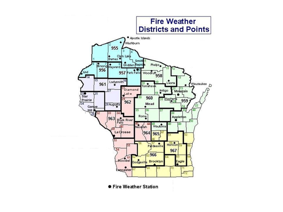
Fire Districts and
NWS Zone Numbers Map |
Fire Weather Watches/Red Flag Warnings
NWS National Fire Weather Page
National Fire Weather Outlooks from the Storm Prediction Center
National Significant Wildland Fire Potential Outlook
Observations
Wisconsin DNR Burning Restrictions and Fire Activity Maps
Great Lakes Fire/Fuels Values
RAWS Observations for Dodgeville, Pardeeville, Horicon, Brooklyn and Eagle
Radar Estimated Precipitation Graphics
Haines Index Map Lower Atmosphere Stability Index, U.S.
Observed Fire Danger Class Map For Previous/Current Day, U.S.
Forecast Fire Danger Class Map For Current/Next Day, U.S.
Visual Greenness Map, U.S.
Satellite Fire Detection
GOES-16 Imagery Use Channel 7: IR "Shortwave Window" (3.9 micron)
Hazard Mapping System - Fire and Smoke Products
Wildfire Automated Biomass Burning Algorithm
Fuel and Soil Moisture Maps
10 Hour Fuel Moisture Map, Weighed Or Computed For 1/4 To 1 Inch Diameter Fuels.
100 Hour Fuel Moisture Map, Weighed Or Computed For 1 To 3 Inch Diameter Fuels.
1000 Hour Fuel Moisture Map, Weighed Or Computed For 3 To 8 Inch Diameter Fuels.
Keetch-Byram Drought Index Soil Moisture Drought Index, U.S.
Palmer Drought Index Updated Weekly, U.S.
U.S. Drought Monitor & Seasonal Outlook
Related Links
Many of the links on the page are courtesy of the U.S. Forest Service. Other Fire Weather-related links include:
Eastern Area Coordination Center
National Interagency Fire Center
Bureau of Land Management
National Park Service
U.S. Fish and Wildlife Service
Fire Weather Program : Some Background
Fire weather forecasts are prepared by the NWS for various fire control agencies in Wisconsin on a seasonal schedule from early Spring to late Fall. Start-up and termination of the fire weather season is mainly related to snow coverage across Wisconsin and will be requested by the U.S. Forest Service and the Wisconsin DNR Bureau of Forestry.
Past history indicates Spring to be the most active season for fire in Wisconsin, since dead fuels are abundant and relative humidity values often drop to very low levels. Fall may be another peak time for the fire weather agencies, due to a new source of fuel from dying vegetation due to freezing temperatures.
-Typical Seasons-
Spring Fire Weather Season....March 15 to June 15
Summer Fire Weather Season....June 15 to September 1
Fall Fire Weather Season....September 1 to November 15
Agencies Supported by the Fire Weather Program:
- United States Forest Service (USFS)
- Chequamegon National Forest in northern Wisconsin
- Nicolet National Forest in northern Wisconsin
- United States Fish and Wildlife Service (USFWS)
- Necedah National Wildlife Refuge
- Horicon National Wildlife Refuge
- Leopold Wetland Management District
- Wisconsin DNR Bureau of Forestry
- Bureau of Indian Affairs
|