Nothing Special   »   [go: up one dir, main page]

2021

NS4672 : The Erskine Bridge

taken 3 years ago, near to Erskine Bridge, Renfrewshire, Scotland
This is 1 of 10 images, with title The Erskine Bridge in this square
The Erskine Bridge
The Erskine Bridge
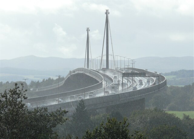
A zoomed view from about 1km away. A heavy rain shower has just passed through, and the spray from vehicles crossing the bridge is visible even from this distance.
Erskine Bridge

The Erskine Bridge is a cable-stayed box girder bridge spanning the River Clyde in west central Scotland, connecting West Dunbartonshire with Renfrewshire.
The bridge was designed by William Brown and opened on 2 July 1971 by HRH Princess Anne. It has a 524m main span and two 68m approach spans and is 38m high and 1310m long. The ceremonial plaque of the opening can be viewed on the railings of the western footpath, at the centre of the main span.
The bridge connects the M898 motorway at Erskine in Renfrewshire on the south side to the A82 road at Old Kilpatrick in West Dunbartonshire on the northern side. The bridge itself is the A898 road. Until 2006 it was a toll bridge.


Creative Commons Licence [Some Rights Reserved]   © Copyright Richard Sutcliffe and licensed for reuse under this Creative Commons Licence.
Geographical Context: Roads, Road transport Air, Sky, Weather Primary Subject: Bridge other tags: Zoomed Picture Spray Click a tag, to view other nearby images.
This photo is linked from: Automatic Clusters: · Crossing [21] · Passing [9] Other Photos: · The Erskine Bridge Title Clusters: · The Erskine Bridge [10] ·
1:50,000 Modern Day Landranger(TM) Map © Crown Copyright
+
+
1:50,000 Modern Day Landranger(TM) Map © Crown Copyright
TIP: Click the map for more Large scale mapping
Grid Square
NS4672, 241 images   (more nearby 🔍)
Photographer
Richard Sutcliffe   (more nearby)
Date Taken
Friday, 1 October, 2021   (more nearby)
Submitted
Friday, 1 October, 2021
Subject Location
OSGB36: geotagged! NS 463 725 [100m precision]
WGS84: 55:55.2570N 4:27.6707W
Camera Location
OSGB36: geotagged! NS 4727 7302
View Direction
West-southwest (about 247 degrees)
Clickable map
+
NW N NE
W Go E
SW S SE
Image Type (about): cross grid 
This page has been viewed about 68 times
You are not logged in login | register