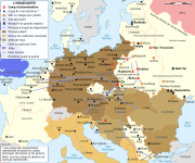
Bestand:WW2-Holocaust-Europe.png

Grootte van deze voorvertoning: 721 × 600 pixels. Andere resoluties: 289 × 240 pixels | 577 × 480 pixels | 923 × 768 pixels | 1.231 × 1.024 pixels | 1.310 × 1.090 pixels.
Oorspronkelijk bestand (1.310 × 1.090 pixels, bestandsgrootte: 639 kB, MIME-type: image/png)
Bestandsgeschiedenis
Klik op een datum/tijd om het bestand te zien zoals het destijds was.
| Datum/tijd | Miniatuur | Afmetingen | Gebruiker | Opmerking | |
|---|---|---|---|---|---|
| huidige versie | 29 okt 2009 14:57 | 1.310 × 1.090 (639 kB) | Flying Saucer | moved Vaivara to it's right place | |
| 20 dec 2007 04:41 | 1.310 × 1.090 (826 kB) | Dna-webmaster~commonswiki | new version without "Axis cooperating" in legend | ||
| 20 dec 2007 03:00 | 1.310 × 1.090 (824 kB) | Dna-webmaster~commonswiki | Now entire West Prussia and Wartheland is included in the Third Reich | ||
| 19 dec 2007 17:42 | 1.310 × 1.090 (828 kB) | Dna-webmaster~commonswiki | still not Da Vinci, but errors have been corrected (Germany borders West/East), West & East Prussia borders/coloring and Poland General Government corrected borders. | ||
| 17 dec 2007 11:46 | 1.310 × 1.090 (825 kB) | Dna-webmaster~commonswiki | new map with 1942 borders, not Da Vinci, but here it goes... | ||
| 19 okt 2007 14:32 | 1.310 × 1.090 (766 kB) | Dna-webmaster~commonswiki | and another update | ||
| 19 okt 2007 13:21 | 1.310 × 1.090 (771 kB) | Dna-webmaster~commonswiki | quick fix | ||
| 19 okt 2007 13:11 | 1.310 × 1.090 (771 kB) | Dna-webmaster~commonswiki | {{Information |Description=Map of the Holocaust in Europe during World War II, 1939-1945. <br> This map shows all extermination camps (or ''death camps''), most major concentration camps, work camps, prison camps, ghettos, major deportation routes and maj |
Bestandsgebruik
Dit bestand wordt op de volgende 3 pagina's gebruikt:
Globaal bestandsgebruik
De volgende andere wiki's gebruiken dit bestand:
- Gebruikt op af.wikipedia.org
- Gebruikt op ar.wikipedia.org
- Gebruikt op az.wikipedia.org
- Gebruikt op be-tarask.wikipedia.org
- Gebruikt op be.wikipedia.org
- Gebruikt op bn.wikipedia.org
- Gebruikt op ca.wikipedia.org
- Gebruikt op cs.wikipedia.org
- Gebruikt op de.wikipedia.org
- Gebruikt op el.wikipedia.org
- Gebruikt op en.wikipedia.org
- Auschwitz concentration camp
- Extermination camp
- Sobibor extermination camp
- Drancy internment camp
- White Buses
- Vel' d'Hiv Roundup
- Template:Image frame
- German war crimes
- René Bousquet
- Holocaust trains
- Portal:Genocide/Selected article
- Portal:Genocide/Selected article/8
- Mechelen transit camp
- User:Dna-webmaster/Projects
- Jewish ghettos in Europe
- List of Jewish ghettos in Europe during World War II
- Template:Image frame/doc
- User:Jnestorius/Resources
- Wikipedia:Featured picture candidates/January-2015
- Wikipedia:Featured picture candidates/Map of the Holocaust in Europe
- The Holocaust in Hungary
- Emigration of Jews from Nazi Germany and German-occupied Europe
- Talk:The Holocaust/Archive 31
- Template:Image frame/sandbox
- Reich Security Head Office Referat IV B4
- Genocides in history (World War I through World War II)
- User:Buidhe/fork
- Gebruikt op en.wikibooks.org
- Gebruikt op en.wiktionary.org
- Gebruikt op es.wikipedia.org
- Gebruikt op et.wikipedia.org
Globaal gebruik van dit bestand bekijken.


