Nothing Special   »   [go: up one dir, main page]

File originale (file in formato SVG, dimensioni nominali 1 500 × 1 615 pixel, dimensione del file: 1,23 MB)

Logo di Commons
Logo di Commons
Questo file e la sua pagina di descrizione (discussione · modifica) si trovano su Wikimedia Commons (?)

Dettagli

Descrizione
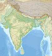
English: Location map of India.

Equirectangular projection. Strechted by 106.0%. Geographic limits of the map:

  • N: 37.5° N
  • S: 5.0° N
  • W: 67.0° E
  • E: 99.0° E
Made with Natural Earth. Free vector and raster map data @ naturalearthdata.com.
Data
Fonte Opera propria
Autore Uwe Dedering di Wikipedia in tedesco
Altre versioni

Opere derivate da questo file:

[modifica]

Licenza

Uwe Dedering di Wikipedia in tedesco, detentore del copyright su quest'opera, dichiara di pubblicarla con le seguenti licenze:
GNU head È permesso copiare, distribuire e/o modificare questo documento in base ai termini della GNU Free Documentation License, Versione 1.2 o successive pubblicata dalla Free Software Foundation; senza alcuna sezione non modificabile, senza testo di copertina e senza testo di quarta di copertina. Una copia della licenza è inclusa nella sezione intitolata Testo della GNU Free Documentation License.
w:it:Creative Commons
attribuzione condividi allo stesso modo
Questo file è disponibile in base alla licenza Creative Commons Attribuzione-Condividi allo stesso modo 3.0 Unported
Tu sei libero:
  • di condividere – di copiare, distribuire e trasmettere quest'opera
  • di modificare – di adattare l'opera
Alle seguenti condizioni:
  • attribuzione – Devi fornire i crediti appropriati, un collegamento alla licenza e indicare se sono state apportate modifiche. Puoi farlo in qualsiasi modo ragionevole, ma non in alcun modo che suggerisca che il licenziante approvi te o il tuo uso.
  • condividi allo stesso modo – Se remixi, trasformi o sviluppi il materiale, devi distribuire i tuoi contributi in base alla stessa licenza o compatibile all'originale.
w:it:Creative Commons
attribuzione condividi allo stesso modo
Questo file è disponibile in base alla licenza Creative Commons Attribuzione-Condividi allo stesso modo 3.0 Germania.
Tu sei libero:
  • di condividere – di copiare, distribuire e trasmettere quest'opera
  • di modificare – di adattare l'opera
Alle seguenti condizioni:
  • attribuzione – Devi fornire i crediti appropriati, un collegamento alla licenza e indicare se sono state apportate modifiche. Puoi farlo in qualsiasi modo ragionevole, ma non in alcun modo che suggerisca che il licenziante approvi te o il tuo uso.
  • condividi allo stesso modo – Se remixi, trasformi o sviluppi il materiale, devi distribuire i tuoi contributi in base alla stessa licenza o compatibile all'originale.
Puoi scegliere la licenza che preferisci.

Depiction of India's borders

  • The territorial boundaries of India are shown as per the actual ground situation in accordance with international practices followed by the United Nations and the National Geographic Society
  • This map is meant to be for illustrative purpose only and is not authenticated by official government sources. Please check the list of sources and references used to create the map for a measure of accuracy and verifiability.
  • The usage of these maps in India, Pakistan and China are governed by different laws that restrict depictions of boundaries other than what is officially recognized by the state. Please check local laws and modify the map accordingly before use.

Explanation of disputed boundaries

  • Boundary of Indian claim : The territory India claims is legally theirs, but the claim is disputed by China and Pakistan.
  • Line of Control/Line of Conflict : The de facto administrative boundary recognised by the international community. This UN ceasefire line is considered as a temporary solution to an ongoing conflict since the departure of the British Raj.

Borders of disputed regions

The extent of the former territory of the British Indian Empire, seceeded by Republic of India depicted on this map may not be accepted by most countries as legal due to ongoing border disputes:

  • The northern Himalayan region of the disputed territory Indian-administered Kashmir is claimed by India including (Pakistan-administered Kashmir) and the Chinese Occupied territory of (Ladakh plateau). It is currently divided between all three countries since 1972. See also Line of Control and Line of Actual Control.
  • Siachen glacier (shown white) is an actively contested region between India and Pakistan. At present the region is in control of India since 1984.
  • The northeastern territory of Arunachal Pradesh is almost entirely claimed by China as part of its Tibetan territory.
  • Minor areas of eastern Ladakh, Himachal Pradesh and Uttarakhand on the Chinese frontier are claimed by China. These areas are under Indian control.
  • A small area of Uttarakhand adjoining the Nepal border along the Sarda river is disputed between the two countries.

For a detailed map of all disputed regions in South Asia, see Image:India disputed areas map.svg

Internal borders

The borders of the state of Meghalaya, Assam and Arunachal Pradesh are shown as interpreted from the North-Eastern Areas (Reorganisation) Act, 1971, but has yet to be verified.

Territorial waters

The limit of the territorial waters of India extends to twelve nautical miles measured from the appropriate baseline. See this copia archiviata at the Wayback Machine for more information.

Registro originale del caricamento

Trasferito da de.wikipedia su Commons da Uwe Dedering.

La pagina di descrizione originale era qui. Tutti i nomi utente che seguono sono riferiti a de.wikipedia.
  • 2010-02-21 16:39 Uwe Dedering 1500×1615× (2412750 bytes) {{Information |Beschreibung = very little borders style changes |Quelle = |Urheber = |Datum = |Genehmigung = |Andere Versionen = |Anmerkungen = }}
  • 2010-02-21 14:16 Uwe Dedering 1500×1615× (2411518 bytes) {{Information |Beschreibung = North now 37.5, changed disputed areas |Quelle = |Urheber = |Datum = |Genehmigung = |Andere Versionen = |Anmerkungen = }}
  • 2010-02-20 16:44 Uwe Dedering 1500×1540× (2246850 bytes) {{Information |Beschreibung = Location map of India. Equirectangular projection. Strechted by 106.0%. Geographic limits of the map: * N: 36.0° N * S: 5.0° N * W: 67.0° E * E: 99.0° E Made with Natural Earth. Free vector and raster map data @ nat

Didascalie

mappa di localizzazione dell'India

Elementi ritratti in questo file

raffigura

coperto da diritti d'autore<\/a>"}},"text\/plain":{"it":{"P6216":"coperto da diritti d'autore"}}}}" class="wbmi-entityview-statementsGroup wbmi-entityview-statementsGroup-P6216 oo-ui-layout oo-ui-panelLayout oo-ui-panelLayout-framed">
creazione originale della persona che ha caricato il file<\/a>"}},"text\/plain":{"it":{"P7482":"creazione originale della persona che ha caricato il file"}}}}" class="wbmi-entityview-statementsGroup wbmi-entityview-statementsGroup-P7482 oo-ui-layout oo-ui-panelLayout oo-ui-panelLayout-framed">

Cronologia del file

Fare clic su un gruppo data/ora per vedere il file come si presentava nel momento indicato.

(ultima | prima) Vedi (10 più recenti | ) (10 | 20 | 50 | 100 | 250 | 500).
Data/OraMiniaturaDimensioniUtenteCommento
attuale10:24, 4 apr 2021Miniatura della versione delle 10:24, 4 apr 20211 500 × 1 615 (1,23 MB)TKsdik8900Fulfilling the edit request (File talk:India location map.svg#Upload more compact version of India location map) by C1MM
17:50, 14 ott 2020Miniatura della versione delle 17:50, 14 ott 20201 500 × 1 615 (1,64 MB)NordNordWestcorrect Telangana/Andhra Pradesh
00:10, 4 nov 2019Miniatura della versione delle 00:10, 4 nov 20191 500 × 1 615 (1,62 MB)RaviCslight colour change for consistency
00:06, 4 nov 2019Miniatura della versione delle 00:06, 4 nov 20191 500 × 1 615 (1,62 MB)RaviC== {{int:filedesc}} == {{Information |Description={{en|Location map of India. Equirectangular projection. Strechted by 106.0%. Geographic limits of the map: * N: 37.5° N * S: 5.0° N * W: 67.0° E * E: 99.0° E Made with Natural Earth. Free vector and raster map data @ naturalearthdata.com.}} |Source={{own}} |Date=2010-02-20 |Author={{user at project|Uwe Dedering|wikipedia|de}} |Permission= |other_versions={{DerivativeVersions|India location map2.svg|India location map 3.png}} {{Other versions/I...
22:42, 19 ago 2014Miniatura della versione delle 22:42, 19 ago 20141 500 × 1 615 (1,59 MB)M0ttyUpdate by Sémhur : add the state of Telangana
12:51, 7 giu 2011Miniatura della versione delle 12:51, 7 giu 20111 500 × 1 615 (1,49 MB)NordNordWestNagaland corrected
17:10, 18 gen 2011Miniatura della versione delle 17:10, 18 gen 20111 500 × 1 615 (2,36 MB)Uwe DederingReverted to version as of 15:50, 17 January 2011 and again, layer structure destroyed, and first discuss this!
20:04, 17 gen 2011Miniatura della versione delle 20:04, 17 gen 20111 500 × 1 615 (1,52 MB)AshwiniKalantriThe disputed land of Kashmir are shown in a different shade.
16:50, 17 gen 2011Miniatura della versione delle 16:50, 17 gen 20111 500 × 1 615 (2,36 MB)Uwe DederingReverted to version as of 11:34, 22 September 2010 vandalism
00:30, 17 gen 2011Miniatura della versione delle 00:30, 17 gen 20111 500 × 1 615 (2,01 MB)AshwiniKalantri{{Information |Description=Location Map of India |Source= |Date= |Author= |Permission= |other_versions= }}
(ultima | prima) Vedi (10 più recenti | ) (10 | 20 | 50 | 100 | 250 | 500).

Utilizzo globale del file

Metadati