Seyssel, Haute-Savoie: Difference between revisions
Content deleted Content added
m r2.7.3) (Robot: Adding sv:Seyssel, Haute-Savoie |
RodRabelo7 (talk | contribs) |
||
| (19 intermediate revisions by 13 users not shown) | |||
| Line 1: | Line 1: | ||
{{Infobox French commune |
{{Infobox French commune |
||
|name = Seyssel |
|name = Seyssel |
||
| |
|commune status = [[Communes of France|Commune]] |
||
| |
|image = Seyssel rive Haute-Savoie.JPG |
||
|caption = The village seen from the West |
|||
|image coat of arms = Blason ville fr Seyssel (Haute-Savoie).svg |
|||
|arrondissement = Saint-Julien-en-Genevois |
|arrondissement = Saint-Julien-en-Genevois |
||
|canton = |
|canton = Saint-Julien-en-Genevois |
||
|INSEE = 74269 |
|INSEE = 74269 |
||
|postal code = 74910 |
|postal code = 74910 |
||
|mayor = Gérard Lambert<ref>{{cite web|title=Répertoire national des élus: les maires|url=https://www.data.gouv.fr/fr/datasets/r/2876a346-d50c-4911-934e-19ee07b0e503|publisher=data.gouv.fr, Plateforme ouverte des données publiques françaises|date=13 September 2022|language=fr}}</ref> |
|||
|mayor = Christian Monteil |
|||
|term = |
|term = 2020–2026 |
||
|intercommunality = |
|intercommunality = CC Usses et Rhône |
||
| |
|coordinates = {{coord|45.9597|5.8372|format=dms|display=inline,title}} |
||
|latitude = 45.9597 |
|||
|elevation m = 265 |
|elevation m = 265 |
||
|elevation min m = 250 |
|elevation min m = 250 |
||
|elevation max m = 937 |
|elevation max m = 937 |
||
|area km2 = 16.86 |
|area km2 = 16.86 |
||
|population = |
|population = {{France metadata Wikidata|population_total}} |
||
|population date = |
|population date = {{France metadata Wikidata|population_as_of}} |
||
|population footnotes = {{France metadata Wikidata|population_footnotes}} |
|||
}} |
}} |
||
'''Seyssel''' is a [[Communes of France|commune]] in the [[Haute-Savoie]] [[Departments of France|department]] in the [[Rhône-Alpes]] [[Regions of France|region]] in south-eastern [[France]]. |
'''Seyssel''' ({{IPA|fr|sɛsɛl}}; {{lang-frp|Sèssél}}) is a [[Communes of France|commune]] in the [[Haute-Savoie]] [[Departments of France|department]] in the [[Auvergne-Rhône-Alpes]] [[Regions of France|region]] in south-eastern [[France]]. |
||
The part of the town across the [[Rhône]] is also named [[Seyssel, Ain|Seyssel]] but located on the western bank of the Rhône in the [[Ain]] department. It is a rare case in France of two homonymous communes adjacent to each other, similar to the situation of the village of [[Saint-Santin]], divided between the communes of [[Saint-Santin]] ([[Aveyron]]) and [[Saint-Santin-de-Maurs]] ([[Cantal]]). |
|||
==Geography== |
==Geography== |
||
The [[Fier |
The [[Fier (river)|Fier]] forms most of the commune's southern border, then flows into the [[Rhône]], which forms the commune's western border. |
||
==Population== |
|||
{{Historical populations |
|||
|source = INSEE<ref name=pophist>[https://www.insee.fr/fr/statistiques/4515315?geo=COM-74269#ancre-POP_T1 Population en historique depuis 1968], INSEE</ref> |
|||
|percentages = pagr |
|||
|align = none |
|||
|1968 |1717 |
|||
|1975 |1725 |
|||
|1982 |1558 |
|||
|1990 |1630 |
|||
|1999 |1793 |
|||
|2007 |2069 |
|||
|2012 |2295 |
|||
|2017 |2325 |
|||
}} |
|||
==See also== |
==See also== |
||
| Line 30: | Line 49: | ||
==References== |
==References== |
||
*[http://www.insee.fr/en/home/home_page.asp INSEE] |
|||
{{Reflist}} |
{{Reflist}} |
||
{{ |
{{Commons category|Seyssel (Haute-Savoie)|Seyssel, Haute-Savoie}} |
||
{{Haute-Savoie communes}} |
{{Haute-Savoie communes}} |
||
{{authority control}} |
|||
[[Category:Communes of Haute-Savoie]] |
[[Category:Communes of Haute-Savoie]] |
||
| Line 40: | Line 60: | ||
{{HauteSavoie-geo-stub}} |
{{HauteSavoie-geo-stub}} |
||
[[ca:Seyssel (Alta Savoia)]] |
|||
[[ceb:Seyssel, Haute-Savoie]] |
|||
[[de:Seyssel (Haute-Savoie)]] |
|||
[[es:Seyssel (Alta Saboya)]] |
|||
[[eo:Seyssel (Haute-Savoie)]] |
|||
[[eu:Seyssel (Savoia Garaia)]] |
|||
[[fr:Seyssel (Haute-Savoie)]] |
|||
[[it:Seyssel (Alta Savoia)]] |
|||
[[lmo:Seyssel (FR-74)]] |
|||
[[mg:Seyssel, Haute-Savoie]] |
|||
[[ms:Seyssel, Haute-Savoie]] |
|||
[[nl:Seyssel (Haute-Savoie)]] |
|||
[[oc:Seyssel]] |
|||
[[pl:Seyssel (Górna Sabaudia)]] |
|||
[[sk:Seyssel (Haute-Savoie)]] |
|||
[[sv:Seyssel, Haute-Savoie]] |
|||
[[uk:Сейсель (Верхня Савойя)]] |
|||
[[vi:Seyssel, Haute-Savoie]] |
|||
[[vo:Seyssel (Haute-Savoie)]] |
|||
[[war:Seyssel, Haute-Savoie]] |
|||
Latest revision as of 07:35, 25 August 2024
Seyssel | |
|---|---|
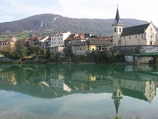 The village seen from the West | |
 Coat of arms | |
Location of Seyssel  | |
 Seyssel  Seyssel | |
| Coordinates: 45°57′35″N 5°50′14″E / 45.9597°N 5.8372°E | |
| Country | France |
| Region | Auvergne-Rhône-Alpes |
| Department | Haute-Savoie |
| Arrondissement | Saint-Julien-en-Genevois |
| Canton | Saint-Julien-en-Genevois |
| Intercommunality | CC Usses et Rhône |
| Government | |
| • Mayor (2020–2026) | Gérard Lambert[1] |
| Area 1 | 16.86 km2 (6.51 sq mi) |
| Population (2021)[2] | 2,342 |
| • Density | 140/km2 (360/sq mi) |
| Time zone | UTC+01:00 (CET) |
| • Summer (DST) | UTC+02:00 (CEST) |
| INSEE/Postal code | 74269 /74910 |
| Elevation | 250–937 m (820–3,074 ft) (avg. 265 m or 869 ft) |
| 1 French Land Register data, which excludes lakes, ponds, glaciers > 1 km2 (0.386 sq mi or 247 acres) and river estuaries. | |
Seyssel (French pronunciation: [sɛsɛl]; Arpitan: Sèssél) is a commune in the Haute-Savoie department in the Auvergne-Rhône-Alpes region in south-eastern France.
The part of the town across the Rhône is also named Seyssel but located on the western bank of the Rhône in the Ain department. It is a rare case in France of two homonymous communes adjacent to each other, similar to the situation of the village of Saint-Santin, divided between the communes of Saint-Santin (Aveyron) and Saint-Santin-de-Maurs (Cantal).
Geography
[edit]The Fier forms most of the commune's southern border, then flows into the Rhône, which forms the commune's western border.
Population
[edit]| Year | Pop. | ±% p.a. |
|---|---|---|
| 1968 | 1,717 | — |
| 1975 | 1,725 | +0.07% |
| 1982 | 1,558 | −1.44% |
| 1990 | 1,630 | +0.57% |
| 1999 | 1,793 | +1.06% |
| 2007 | 2,069 | +1.81% |
| 2012 | 2,295 | +2.09% |
| 2017 | 2,325 | +0.26% |
| Source: INSEE[3] | ||
See also
[edit]References
[edit]- ^ "Répertoire national des élus: les maires" (in French). data.gouv.fr, Plateforme ouverte des données publiques françaises. 13 September 2022.
- ^ "Populations légales 2021" (in French). The National Institute of Statistics and Economic Studies. 28 December 2023.
- ^ Population en historique depuis 1968, INSEE
Wikimedia Commons has media related to Seyssel, Haute-Savoie.
| International | |
|---|---|
| National | |
| Other | |
This Haute-Savoie geographical article is a stub. You can help Wikipedia by expanding it. |