List of airports in Bhutan: Difference between revisions
Content deleted Content added
GreenC bot (talk | contribs) Rescued 1 archive link; reformat 1 citation per WP:USURPURL and WP:JUDI. Wayback Medic 2.5 |
|||
| (46 intermediate revisions by 34 users not shown) | |||
| Line 1: | Line 1: | ||
{{short description|None}} |
|||
[[File:Bhutan CIA WFB 2010 map.png|thumb|right|200px|Map of Bhutan]] |
[[File:Bhutan CIA WFB 2010 map.png|thumb|right|200px|Map of Bhutan]] |
||
This is a '''list of [[airport]]s in [[Bhutan]]''', sorted by location. |
This is a '''list of [[airport]]s in [[Bhutan]]''', sorted by location. |
||
Bhutan, officially the Kingdom of Bhutan, is a [[landlocked]] country in [[South Asia]], located at the eastern end of the [[Himalaya Mountains]] and bordered to the south, east and west by the [[Republic of India]] and to the north by [[Tibet]]. Bhutan |
Bhutan, officially the Kingdom of Bhutan, is a [[landlocked]] country in [[South Asia]], located at the eastern end of the [[Himalaya Mountains]] and bordered to the south, east and west by the [[Republic of India]] and to the north by [[Tibet]]. Bhutan is separated from the nearby state of [[Nepal]] to the west by the Indian state of [[Sikkim]], and from [[Bangladesh]] to the south by [[West Bengal]]. The [[capital city]] is [[Thimphu]]. |
||
__TOC__ |
|||
{{clear}} |
|||
== Airports == |
== Airports == |
||
| Line 20: | Line 19: | ||
! style="text-align:left;" | Runway |
! style="text-align:left;" | Runway |
||
! style="text-align:left;" | Elev. |
! style="text-align:left;" | Elev. |
||
! style="text-align:left;" | Constructed |
|||
! style="text-align:left;" | Status |
|||
| ⚫ | |||
| ⚫ | |||
| VQGP |
|||
| GLU |
|||
| ⚫ | |||
| ⚫ | |||
| ⚫ | |||
| ⚫ | |||
| <small>2008</small> |
|||
| <small>Operational</small> |
|||
|- valign="top" |
|||
| [[Jakar]] |
|||
| VQBT |
|||
| BUT |
|||
| '''[[Bathpalathang Airport]]''' |
|||
| <small>{{nowrap|{{coord|27|33|52|N|090|44|43|E|region:BT_type:airport|name=Bathpalathang Airport}}}}</small> |
|||
| <small>14/32: 1200 m<br>Asphalt</small> |
|||
| <small>2473 m</small> |
|||
| <small>2011</small> |
|||
| <small>Operational</small> |
|||
|- valign="top" |
|- valign="top" |
||
| Line 25: | Line 48: | ||
| VQPR |
| VQPR |
||
| PBH |
| PBH |
||
| '''[[Paro Airport]]''' |
| '''[[Paro International Airport]]''' |
||
| <small>{{coord|27|24| |
| <small>{{nowrap|{{coord|27|24|12|N|089|25|29|E|region:BT_type:airport|name=Paro Airport}}}}</small> |
||
| <small>15/33: 1964 x 29 m |
| <small>15/33: 1964 x 29 m<br>Asphalt</small> |
||
| <small>2235 m</small> |
| <small>2235 m</small> |
||
| <small>1968</small> |
|||
| <small>Operational</small> |
|||
|- valign="top" |
|- valign="top" |
||
| [[Trashigang]] |
| [[Trashigang]] |
||
| VQTY |
|||
| <!--DAFIF: VQ10--> |
|||
| YON |
|||
| |
|||
| [[Yongphulla Airport]] |
|''' [[Yongphulla Airport]]'''<br>(Yonphula Airport) |
||
| <small>{{coord|27|15| |
| <small>{{nowrap|{{coord|27|15|22|N|091|30|55|E|region:BT_type:airport|name=Yongphulla Airport}}}}</small> |
||
| <small>12/30: 1266 x 37 m |
| <small>{{nowrap|12/30: 1266 x 37 m}}<br>Asphalt</small> |
||
| <small>2743 m</small> |
| <small>2743 m</small> |
||
| <small>2010</small> |
|||
| <small>Operational</small> |
|||
| ⚫ | |||
| ⚫ | |||
| VQTU |
|||
| QJC |
|||
| ⚫ | |||
| ⚫ | |||
| ⚫ | |||
| ⚫ | |||
|} |
|} |
||
[[Bagdogra Airport]] ({{Coord|26|40|52|N|088|19|43|E|type:airport}}) in neighbouring India is also accessible for flights to Bhutan. |
|||
== See also == |
== See also == |
||
{{GeoGroup}} |
|||
{{GeoGroupTemplate}} |
|||
* [[Transport in Bhutan]] |
* [[Transport in Bhutan]] |
||
* [[List of airports by ICAO code: V |
* [[List of airports by ICAO code: V]] |
||
* [[Wikipedia:WikiProject Aviation/Airline destination lists: Asia#Bhutan]] |
|||
== References == |
== References == |
||
| ⚫ | |||
| ⚫ | |||
| ⚫ | |||
| ⚫ | |||
| ⚫ | |||
{{reflist}} |
{{reflist}} |
||
| ⚫ | |||
| ⚫ | |||
| ⚫ | |||
| ⚫ | |||
| ⚫ | |||
<!--Navigation box--><br /> |
<!--Navigation box--><br /> |
||
{{Airports in Bhutan}} |
|||
{{Asia in topic|List of airports in}} |
{{Asia in topic|List of airports in}} |
||
| Line 70: | Line 89: | ||
[[Category:Airports in Bhutan| ]] |
[[Category:Airports in Bhutan| ]] |
||
[[Category:Lists of airports by country|Bhutan]] |
[[Category:Lists of airports by country|Bhutan]] |
||
[[Category:Bhutan-related lists|Airports]] |
[[Category:Bhutan transport-related lists|Airports]] |
||
[[Category:Lists of buildings and structures in Bhutan|Airports]] |
|||
[[Category:Lists of airports in Asia|Bhutan]] |
|||
<!--Other languages--> |
|||
[[de:Liste der Flughäfen in Bhutan]] |
|||
[[ja:ブータンの空港の一覧]] |
|||
[[ru:Список аэропортов Бутана]] |
|||
Latest revision as of 04:55, 11 November 2023
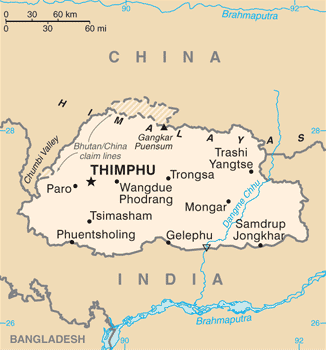
This is a list of airports in Bhutan, sorted by location.
Bhutan, officially the Kingdom of Bhutan, is a landlocked country in South Asia, located at the eastern end of the Himalaya Mountains and bordered to the south, east and west by the Republic of India and to the north by Tibet. Bhutan is separated from the nearby state of Nepal to the west by the Indian state of Sikkim, and from Bangladesh to the south by West Bengal. The capital city is Thimphu.
Airports
[edit]Airport names shown in bold have scheduled passenger service on commercial airlines.
| Location | ICAO | IATA | Airport name | Coordinates | Runway | Elev. | Constructed | Status |
|---|---|---|---|---|---|---|---|---|
| Gelephu | VQGP | GLU | Gelephu Airport | 26°53′04″N 090°27′51″E / 26.88444°N 90.46417°E | 11/29: 1500 m Asphalt |
290 m | 2008 | Operational |
| Jakar | VQBT | BUT | Bathpalathang Airport | 27°33′52″N 090°44′43″E / 27.56444°N 90.74528°E | 14/32: 1200 m Asphalt |
2473 m | 2011 | Operational |
| Paro | VQPR | PBH | Paro International Airport | 27°24′12″N 089°25′29″E / 27.40333°N 89.42472°E | 15/33: 1964 x 29 m Asphalt |
2235 m | 1968 | Operational |
| Trashigang | VQTY | YON | Yongphulla Airport (Yonphula Airport) |
27°15′22″N 091°30′55″E / 27.25611°N 91.51528°E | 12/30: 1266 x 37 m Asphalt |
2743 m | 2010 | Operational |
Bagdogra Airport (26°40′52″N 088°19′43″E / 26.68111°N 88.32861°E) in neighbouring India is also accessible for flights to Bhutan.
See also
[edit]References
[edit]- "ICAO Location Indicators by State" (PDF). International Civil Aviation Organization. 17 September 2010.
- "UN Location Codes: Bhutan (includes IATA codes)". UN/LOCODE 2011-2. UNECE. 28 February 2012.
- Airports in Bhutan[usurped] World Aero Data
- Airports in Bhutan Great Circle Mapper
- Airports in Bhutan FallingRain.com