Dover, Singapore: Difference between revisions
No edit summary |
|||
| (36 intermediate revisions by 24 users not shown) | |||
| Line 1: | Line 1: | ||
{{ |
{{more citations needed|date=December 2010}} |
||
{{Infobox |
{{Infobox settlement |
||
| |
| name = Dover |
||
| |
| settlement_type = Subzone of [[Queenstown, Singapore|Queenstown]] Planning Area |
||
| translit_lang1 = Other |
|||
| ⚫ | |||
| translit_lang1_type1 = [[Standard Chinese|Chinese]] |
|||
| englishname = Dover |
|||
| |
| translit_lang1_info1 = 杜弗 |
||
| translit_lang1_type2 = [[Pinyin]] |
|||
| poj = |
|||
| translit_lang1_info2 = Dù fú |
|||
| pengim = |
|||
| translit_lang1_type3 = [[Malay language|Malay]] |
|||
| pinyin = Dùfó |
|||
| |
| translit_lang1_info3 = Dover |
||
| translit_lang1_type4 = [[Tamil language|Tamil]] |
|||
| |
| translit_lang1_info4 = டோவெர் |
||
| image_skyline= {{Photomontage |
|||
| photo1a = 1 singapore polytechnic panorama 2010.JPG |
|||
| photo2a = Dover Parkview (8541642294).jpg |
|||
| photo2b = Dover MRT Station 4, Dec 06.JPG |
|||
| photo3a = Public Housing, Dover, Singapore (3362885458).jpg |
|||
| size = 280 |
|||
| spacing = 2 |
|||
| color = transparent |
|||
| border = 0 |
|||
}} |
}} |
||
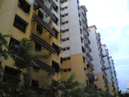
| caption = From top left to right: Panoramic view of [[Singapore Polytechnic]], Dover Parkview, [[Dover MRT station]], Dover Gardens |
|||
| ⚫ | |||
| ⚫ | |||
'''Dover''' is a relatively small [[List of Towns, Estates and Neighbourhoods in Singapore|neighbourhood]] of [[Singapore]], located in [[Queenstown, Singapore|Queenstown]]. It is south of [[Ghim Moh]] and north of [[Kent Ridge]]. It is often a noted location due to the sheer number of educational facilities it holds, while lying in a zone between Singapore's [[central business district]] in the [[Central Area]] and her industrial zone in the vicinity of [[Jurong]]. The general geographical area is classified under the [[Queenstown Planning Area]] by the [[Urban Redevelopment Authority]], and is a few kilometres away from Queenstown itself. |
|||
| pushpin_map = Singapore |
|||
| pushpin_map_caption = Location of Dover within Singapore |
|||
| coordinates = {{coord|1|18|16.5|N|103|46|49.1|E|display=inline}} |
|||
| subdivision_type = Country |
|||
| subdivision_name = {{flag|Singapore}} |
|||
| subdivision_type1 = Region |
|||
| subdivision_name1 = [[Central Region, Singapore|Central Region]] |
|||
---- |
|||
| subdivision_type2 = [[Community Development Council|CDC]] |
|||
| subdivision_name2 = * [[South West Community Development Council|South West CDC]] |
|||
| subdivision_type3 = Town council |
|||
| subdivision_name3 = * West Coast Town Council |
|||
| subdivision_type4 = [[Constituencies of Singapore|Constituency]] |
|||
| subdivision_name4 = * [[West Coast Group Representation Constituency|West Coast GRC]] |
|||
| leader_title = Mayor |
|||
| leader_name = '''South West CDC''' |
|||
* [[Low Yen Ling]] |
|||
---- |
|||
| leader_title1 = Members of Parliament |
|||
| leader_name1 = '''West Coast GRC''' |
|||
* [[Rachel Ong]] |
|||
| area_footnotes = <ref name=citypopulation>[http://www.citypopulation.de/php/singapore-admin.php?adm2id=11502 Dover (Subzone, Singapore) - Population Statistics, Charts, Map and Location]</ref> |
|||
| area_total_km2 = 1.39 |
|||
| population_as_of = 2017 |
|||
| population_footnotes = <ref name=citypopulation /> |
|||
| population_total = 11,710 |
|||
| population_density_km2 = auto |
|||
| population_demonym = '''Official''' |
|||
* Dover resident |
|||
| postal_code_type = Postal district |
|||
| postal_code = 5 |
|||
| ⚫ | |||
| ⚫ | |||
'''Dover''' is a relatively small [[List of Towns, Estates and Neighbourhoods in Singapore|neighbourhood]] of Singapore, located in [[Queenstown, Singapore|Queenstown]]. It is bordered by [[Ghim Moh]] to the north, [[Kent Ridge]] to the south and southeast, [[one-north]] and [[Queenstown, Singapore|Queenstown]] to the east, [[Commonwealth, Singapore|Commonwealth]] and [[Holland Village, Singapore|Holland Village]] to the northeast [[Clementi, Singapore|Clementi]] to the west and [[West Coast, Singapore|West Coast]] to the southwest. It is often a noted location due to the sheer number of [[Educational institution|educational facilities]] it holds, while lying in a zone between the [[Central Area, Singapore|Central Area]] and near industrial zone in the vicinity of [[Jurong]]. |
|||
==Etymology and history== |
==Etymology and history== |
||
The |
The Dover neighbourhood was formerly a [[British military]] and [[residential]] area. Hence, many road names in the area are derived from [[England|English]] (specifically [[Kent]]ish) place names. For example, those in Medway Park off Dover Road include names associated with the southern [[coast]]al areas of England, including [[Folkestone]] and [[Maidstone]], apart from [[Dover]] itself. The name "Dover" is from the Celtic word meaning "The Waters", alluding to the [[English Channel]]. Medway Park, for instance, is named after the [[River Medway]], which marks the middle of Kent. [[Kent]] is the [[English county]] where the town of [[Dover]], the namesake is located.<ref>Victor R Savage, Brenda S A Yeoh (2003), ''Toponymics - A Study of Singapore Street Names'', Eastern Universities Press, {{ISBN|981-210-205-1}}</ref> |
||
==Roads in Dover== |
==Roads in Dover== |
||
| Line 26: | Line 71: | ||
==Transport== |
==Transport== |
||
There are two [[Mass Rapid Transit (Singapore)|Mass Rapid Transit]] (MRT) stations which are in proximity to Dover. One is [[Dover MRT |
There are two [[Mass Rapid Transit (Singapore)|Mass Rapid Transit]] (MRT) stations which are in proximity to Dover. One is [[Dover MRT station]], which is EW22 on the [[East West MRT line]], and the other is [[Buona Vista MRT station]] which is EW21/CC22. However, neither MRT station is situated near the heart of Dover. The former is located next to [[Singapore Polytechnic]], whilst the latter at the intersection of [[North Buona Vista Road]] and Commonwealth Avenue. A portion of most residents drop at Dover MRT station ([[East West MRT line|East West line]]) and transfer to a bus (14, 74, 105, 106, 166 or 185), while another portion drop at [[Buona Vista MRT station]] (East West line and [[Circle MRT line|Circle line]]), takes a kilometre walk to Dover or transfer to buses 14, 74 or 196. Alternately, [[one-north MRT station]] is within walking distance of the eastern end of Dover, although not being located in it. |
||
In addition, the following bus services pass through Dover: |
|||
*SBS Transit |
|||
{| style="text-align:centre; font-size:95%; border:1px solid black" |
|||
! Service !! Between !! And |
|||
|- |
|||
! colspan="4" style="background-color:purple;color:white; height:35px" | SBS Transit Trunk Services |
|||
|- |
|||
| style="background-color:purple;color:white;text-align:center;font-weight:bold;" | 14 || [[Clementi Bus Interchange]] || [[Bedok Bus Interchange]] |
|||
|- |
|||
| style="background-color:purple;color:white;text-align:center;font-weight:bold;" | 33 || [[Kent Ridge Bus Terminal]] || [[Bedok Bus Interchange]] |
|||
|- |
|||
| style="background-color:purple;color:white;text-align:center;font-weight:bold;" | 74 || [[Buona Vista Bus Terminal]] || [[Hougang Central Bus Interchange]] |
|||
|- |
|||
| style="background-color:purple;color:white;text-align:center;font-weight:bold;" | 166 || [[Clementi Bus Interchange]] || [[Ang Mo Kio Bus Interchange]] |
|||
|- |
|||
| style="background-color:purple;color:white;text-align:center;font-weight:bold;" | 196 || [[Clementi Bus Interchange]] || [[Bedok Bus Interchange]] |
|||
|- |
|||
| ⚫ | |||
==Education== |
==Education== |
||
| Line 59: | Line 85: | ||
**[[Nan Hua High School]] |
**[[Nan Hua High School]] |
||
**[[New Town Secondary School]] |
**[[New Town Secondary School]] |
||
**[[NUS High School of |
**[[NUS High School of Math and Science]] |
||
**[[School of Science and Technology, Singapore]] |
**[[School of Science and Technology, Singapore]] |
||
*Higher institutions of learning |
*Higher institutions of learning |
||
**[[National University of Singapore]] (NUS) (Kent Ridge) |
**[[National University of Singapore]] (NUS) (Kent Ridge) |
||
**[[Singapore |
**[[Singapore Institute of Technology]] (SIT) (Dover Campus, previously occupied by [[Singapore University of Technology and Design]] till 2015) |
||
**[[Singapore Polytechnic]] |
**[[Singapore Polytechnic]] |
||
**[[Anglo-Chinese Junior College]] |
**[[Anglo-Chinese Junior College]] |
||
**[[ITE College West]] (Clementi Campus) |
|||
**[[ITE College West]] (Dover Campus) |
|||
**[[INSEAD]] |
**[[INSEAD]] |
||
*International schools |
*International schools |
||
** |
**[[Dover Court International School]] |
||
** [[Japanese Secondary School]] (Clementi) |
** [[Japanese Secondary School]] (Clementi) |
||
** [[Norwegian Supplementary School]] |
** [[Norwegian Supplementary School]] |
||
| Line 78: | Line 102: | ||
==References== |
==References== |
||
{{Reflist}} |
|||
| ⚫ | |||
*Victor R Savage, Brenda S A Yeoh (2003), ''Toponymics - A Study of Singapore Street Names'', Eastern Universities Press, ISBN 981-210-205-1 |
|||
| ⚫ | |||
{{Places in Singapore}} |
{{Places in Singapore}} |
||
{{Public housing in Singapore}} |
{{Public housing in Singapore}} |
||
{{coord missing|Singapore}} |
|||
| ⚫ | |||
[[Category:Places in Singapore]] |
[[Category:Places in Singapore]] |
||
[[Category:Housing estates in Singapore]] |
[[Category:Housing estates in Singapore]] |
||
[[Category:Queenstown, Singapore]] |
[[Category:Queenstown, Singapore]] |
||
| ⚫ | |||
Latest revision as of 09:12, 18 August 2024
This article needs additional citations for verification. (December 2010) |
Dover | |
|---|---|
Subzone of Queenstown Planning Area | |
| Other transcription(s) | |
| • Chinese | 杜弗 |
| • Pinyin | Dù fú |
| • Malay | Dover |
| • Tamil | டோவெர் |
    From top left to right: Panoramic view of Singapore Polytechnic, Dover Parkview, Dover MRT station, Dover Gardens | |
 | |
 Dover Location of Dover within Singapore | |
| Coordinates: 1°18′16.5″N 103°46′49.1″E / 1.304583°N 103.780306°E | |
| Country | |
| Region | Central Region
|
| CDC | |
| Town council |
|
| Constituency | |
| Government | |
| • Mayor | South West CDC
|
| • Members of Parliament | West Coast GRC |
| Area | |
| • Total | 1.39 km2 (0.54 sq mi) |
| Population (2017)[1] | |
| • Total | 11,710 |
| • Density | 8,400/km2 (22,000/sq mi) |
| Demonym | Official
|
| Postal district | 5 |

Dover is a relatively small neighbourhood of Singapore, located in Queenstown. It is bordered by Ghim Moh to the north, Kent Ridge to the south and southeast, one-north and Queenstown to the east, Commonwealth and Holland Village to the northeast Clementi to the west and West Coast to the southwest. It is often a noted location due to the sheer number of educational facilities it holds, while lying in a zone between the Central Area and near industrial zone in the vicinity of Jurong.
Etymology and history
[edit]The Dover neighbourhood was formerly a British military and residential area. Hence, many road names in the area are derived from English (specifically Kentish) place names. For example, those in Medway Park off Dover Road include names associated with the southern coastal areas of England, including Folkestone and Maidstone, apart from Dover itself. The name "Dover" is from the Celtic word meaning "The Waters", alluding to the English Channel. Medway Park, for instance, is named after the River Medway, which marks the middle of Kent. Kent is the English county where the town of Dover, the namesake is located.[2]
Roads in Dover
[edit]- Dover Road
- Dover Crescent
- Dover Close East
- Dover Avenue
- Dover Drive
- Dover Rise
Transport
[edit]There are two Mass Rapid Transit (MRT) stations which are in proximity to Dover. One is Dover MRT station, which is EW22 on the East West MRT line, and the other is Buona Vista MRT station which is EW21/CC22. However, neither MRT station is situated near the heart of Dover. The former is located next to Singapore Polytechnic, whilst the latter at the intersection of North Buona Vista Road and Commonwealth Avenue. A portion of most residents drop at Dover MRT station (East West line) and transfer to a bus (14, 74, 105, 106, 166 or 185), while another portion drop at Buona Vista MRT station (East West line and Circle line), takes a kilometre walk to Dover or transfer to buses 14, 74 or 196. Alternately, one-north MRT station is within walking distance of the eastern end of Dover, although not being located in it.
Education
[edit]
Dover is known for having many schools and education institutions in its neighbourhood and vicinity.
- Primary schools
- Secondary schools
- Higher institutions of learning
- National University of Singapore (NUS) (Kent Ridge)
- Singapore Institute of Technology (SIT) (Dover Campus, previously occupied by Singapore University of Technology and Design till 2015)
- Singapore Polytechnic
- Anglo-Chinese Junior College
- INSEAD
- International schools
- Other education institutions
References
[edit]- ^ a b Dover (Subzone, Singapore) - Population Statistics, Charts, Map and Location
- ^ Victor R Savage, Brenda S A Yeoh (2003), Toponymics - A Study of Singapore Street Names, Eastern Universities Press, ISBN 981-210-205-1
