Dörth: Difference between revisions
Dr. Blofeld (talk | contribs) ←Created page with ''''Dörth''' is a municipality in the district of Rhein-Hunsrück in Rhineland-Palatinate, western Germany. {{Cities and towns in Rhein-Hunsrück-Krei...' |
m resolve link to disambig page, lang-template, WP:APOSTROPHE, WP:CURLY |
||
| (40 intermediate revisions by 30 users not shown) | |||
| Line 1: | Line 1: | ||
{{more citations needed|date=July 2015}} |
|||
'''Dörth''' is a municipality in the district of [[Rhein-Hunsrück]] in [[Rhineland-Palatinate]], western [[Germany]]. |
|||
{{Infobox German location |
|||
| type = Ortsgemeinde |
|||
| image_coa = DEU Dörth COA.svg |
|||
| coordinates = {{coord|50|8|56.48|N|7|35|23.50|E|format=dms|display=inline,title}} |
|||
| image_plan = Dörth in SIM.svg |
|||
| state = Rheinland-Pfalz |
|||
| district = Rhein-Hunsrück-Kreis |
|||
| Verbandsgemeinde = Hunsrück-Mittelrhein |
|||
| elevation = 465 |
|||
| area = 5.16 |
|||
| postal_code = 56281 |
|||
| area_code = 06747 |
|||
| licence = SIM |
|||
| Gemeindeschlüssel = 07 1 40 031 |
|||
| website = {{URL|http://www.doerth.de/}} |
|||
| mayor = Thomas Blum<ref name=mayor>[https://www.wahlen.rlp.de/de/kw/wahlen/kd/gebiete/1400000000000.html Direktwahlen 2019, Rhein-Hunsrück-Kreis], Landeswahlleiter Rheinland-Pfalz, accessed 4 August 2021.</ref> |
|||
| leader_term = 2019–24 |
|||
| party = |
|||
}} |
|||
'''Dörth''' is an {{lang|de|[[Ortsgemeinde (Germany)|Ortsgemeinde]]}} – a [[Municipalities of Germany|municipality]] belonging to a {{lang|de|[[Verbandsgemeinde]]}}, a kind of collective municipality – in the [[Rhein-Hunsrück-Kreis]] ([[Districts of Germany|district]]) in [[Rhineland-Palatinate]], [[Germany]]. It belongs to the ''Verbandsgemeinde'' [[Hunsrück-Mittelrhein]], whose seat is in [[Emmelshausen]]. |
|||
==Geography== |
|||
| ⚫ | |||
===Location=== |
|||
| ⚫ | |||
The municipality lies in the [[Hunsrück]] about 2.5 km east of [[Emmelshausen]] on the [[Autobahn]] [[Bundesautobahn 61|A 61]]. [[Sankt Goar]] lies roughly 8 km to the east, and the river [[Rhine]]’s nearest approach to Dörth is at Hirzenach, an outlying centre of [[Boppard]], roughly 5 km to the northeast. |
|||
==History== |
|||
{{RheinHunsrück-geo-stub}} |
|||
In 1334, Dörth was first mentioned by name. It first arose as a clearing village and was once called ''Denrod'' (the ''—rod'' ending stems from the same root as the [[German language|German]] verb ''roden'', meaning “clear”, with reference to woods). In the latter half of the 14th century, the villagers forsook Dörth for a few years, but it is believed that the village was reoccupied within a decade. In 1375, Dörth had its first documentary mention<!--No, I have no idea what the difference is between being mentioned by name and a first documentary mention, but that’s what the source says.-->. The actual document deals with an agreement in which the agreed sharing of tithes from the area under the Gallscheid Court's (''Gallscheider Gericht'') jurisdiction between the Provost of Saint Martin's Foundation at [[Worms, Germany|Worms]] and his [[chapter (religion)|chapter]] is recorded. Dörth was grouped with those villages that had to pay the tithe not to the Provost, but rather to the chapter. The tithe lord (or ''Decimator'') in Dörth was until 1521 Saint Martin's Foundation at Worms. Old documents speak of ''Denrod'' or ''Dinrod''. The villagers worked mainly at [[Agriculture|farming]] and in the forest. |
|||
Beginning in 1521, the ''Decimator'' was the [[Electorate of Trier|Elector of Trier]]. Since the village belonged to the Electorate of Trier, it remained [[Catholic Church|Roman Catholic]] even through the [[Protestant Reformation|upheavals over religion]] in the 16th century. The parish seat as far back as is known has been [[Halsenbach]], although [[Saint Quentin]]’s Church in [[Karbach, Rhineland-Palatinate|Karbach]] was nearer than the parish church in Halsenbach. Beginning in 1556, Saint Quentin’s was likewise part of the parish of Halsenbach. Dörth was one of the smallest villages in the parish, and at the onset of the [[Thirty Years' War]] had no more than five hearths (households). |
|||
[[de:Dörth]] |
|||
Towards the end of the 17th century, there must have been some kind of small population explosion. Two effects that this had in the earlier half of the 18th century cannot be overlooked: a [[chapel]] was built, and so was a [[school]]. |
|||
At the beginning of the 19th century, Dörth, like all the lands on the Rhine’s left bank, lay under [[France|French]] rule. The French brought fundamental changes to the Rhineland: they swept away both tithes and [[serfdom]]. After French rule ended some 20 years later, Dörth passed along with the Rhineland to the Kingdom of [[Prussia]] under the terms of the [[Congress of Vienna]], becoming part of the [[Rhine Province]]. In 1816, within the newly formed Sankt Goar district, Dörth at first remained in the ''Amtsbürgermeisterei'' of Pfalzfeld, as it had been in French times. As a result of the villagers’ wishes, however, it was grouped together in 1817 with Karbach into the ''[[Amt (country subdivision)|Amt]]'' of Halsenbach, thus reinstating the structure from Electoral-Trier times. Between 1922 and 1925, a new church and a new school were built. |
|||
In the [[First World War|First]] and [[Second World War]]s, 52 men from the municipality fell or went [[missing in action]]. Since 1946, Dörth has been part of the then newly founded [[States of Germany|state]] of [[Rhineland-Palatinate]]. In the late 1940s, with currency reform and the establishment of the [[West Germany|Federal Republic of Germany]], there was once more solid ground to stand on. Dörth became the seat of the new parish. The economic upswing in the 1950s and 1960s and the gradual [[industrialization]] also took root in the Hunsrück. Where once the [[Celts]] and the [[Ancient Rome|Romans]] built their ancient roads, the Autobahn along the Rhine's left bank sprang up. Dörth has an Autobahn [[interchange (road)|interchange]] within its municipal limits (although it is called ''Emmelshausen''). In the outlying locality of Hirtenau are found a [[Road maintenance depot|maintenance depot]] and the Autobahn police.<ref>{{Cite web |url=http://www.doerth.gewerbepark-doerth.de/index.php?id=12 |title=Dörth’s history |access-date=2011-01-12 |archive-url=https://web.archive.org/web/20110128024155/http://www.doerth.gewerbepark-doerth.de/index.php?id=12 |archive-date=2011-01-28 |url-status=dead }}</ref> |
|||
==Politics== |
|||
===Municipal council=== |
|||
The council is made up of 12 council members, who were elected by [[Plurality voting system|majority vote]] at the municipal election held on 7 June 2009, and the honorary mayor as chairman.<ref>[http://www.wahlen.rlp.de/kw/wahlen/2009/gemeinderatswahlen/ergebnisse/1400203100.html Kommunalwahl Rheinland-Pfalz 2009, Gemeinderat]</ref> |
|||
===Mayor=== |
|||
Dörth's mayor is Thomas Blum.<ref name=mayor/> |
|||
===Coat of arms=== |
|||
The German blazon reads: ''Schild durch eine gestürzte Spitze gespalten, darin ein wachsendes goldenes Kreuz, belegt mit blauem Schwert; vorne ein rotes Balkenkreuz in Silber; hinten ein silberner Balken in Rot.''<ref name="VG">[http://www.emmelshausen.de/vg_emmelshausen/Gemeinden/D%C3%B6rth/ Beschreibung des Wappens auf der VG-Internetpräsents]</ref> |
|||
The municipality's [[Coat of arms|arms]] might in English [[Heraldry|heraldic]] language be described thus: Tierced in mantle reversed, argent a cross abased gules, azure issuant from base a cross Latin, the dexter and sinister arms couped short of the lines of partition, Or surmounted by a sword palewise, the point to base, of the field, and gules a fess abased of the first. |
|||
The red cross on the dexter (armsbearer's right, viewer's left) side is the armorial device formerly borne by the [[Electorate of Trier]], thus denoting the village's allegiance in the [[Middle Ages]]. The silver fess on the sinister (armsbearer's left, viewer's right) side is from the arms once borne by the Gallscheid Court (''Gallscheider Gericht''), thus referring to the local jurisdiction then. The [[charge (heraldry)|charge]]s in the middle, the gold cross and the blue sword, stand for [[Philip the Apostle]] and [[James, son of Zebedee|James the Elder]], who are the municipality's patron saints.<ref name="VG" /> |
|||
==Culture and sightseeing== |
|||
===Buildings=== |
|||
The following are listed buildings or sites in [[Rhineland-Palatinate]]’s Directory of Cultural Monuments:<ref>[http://denkmallisten.gdke-rlp.de/Rhein-Hunsrueck-Kreis.pdf Directory of Cultural Monuments in Rhein-Hunsrück district]</ref> |
|||
* Saint Philip’s and Saint James’s [[Catholic Church|Catholic]] Parish Church (''Pfarrkirche St. Philippus und Jakobus''), Hauptstraße 7 – [[aisleless church]], 1922/1923 |
|||
* Schulstraße 7 – [[Timber framing|timber-frame]] ''Quereinhaus'' (a combination residential and commercial house divided for these two purposes down the middle, perpendicularly to the street), partly solid and slated, half-hipped roof, early 19th century; whole complex of buildings |
|||
==Economy and infrastructure== |
|||
Dörth lies between the Autobahn A 61 (''Emmelshausen'' interchange) and the ''Hunsrückhöhenstraße'' ("Hunsrück Heights Road", a scenic road across the Hunsrück built originally as a military road on [[Hermann Göring]]'s orders). About a kilometre outside the village lies the Dörth industrial park with some 80 businesses and some 1,000 jobs. |
|||
==References== |
|||
{{reflist}} |
|||
==External links== |
|||
* [https://web.archive.org/web/20100420062445/http://www.doerth.de/ Municipality’s official webpage] {{in lang|de}} |
|||
| ⚫ | |||
{{Authority control}} |
|||
{{DEFAULTSORT:Dorth}} |
|||
| ⚫ | |||
[[Category:Rhein-Hunsrück-Kreis]] |
|||
Latest revision as of 13:25, 1 June 2023
This article needs additional citations for verification. (July 2015) |
Dörth | |
|---|---|
 Coat of arms | |
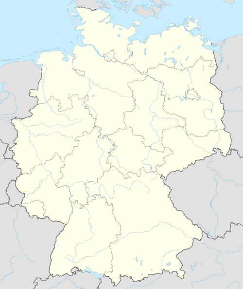
Location of Dörth within Rhein-Hunsrück-Kreis district  | |
 Dörth 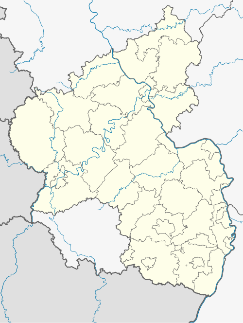 Dörth | |
| Coordinates: 50°8′56.48″N 7°35′23.50″E / 50.1490222°N 7.5898611°E | |
| Country | Germany |
| State | Rhineland-Palatinate |
| District | Rhein-Hunsrück-Kreis |
| Municipal assoc. | Hunsrück-Mittelrhein |
| Government | |
| • Mayor (2019–24) | Thomas Blum[1] |
| Area | |
| • Total | 5.16 km2 (1.99 sq mi) |
| Elevation | 465 m (1,526 ft) |
| Population (2022-12-31)[2] | |
| • Total | 528 |
| • Density | 100/km2 (270/sq mi) |
| Time zone | UTC+01:00 (CET) |
| • Summer (DST) | UTC+02:00 (CEST) |
| Postal codes | 56281 |
| Dialling codes | 06747 |
| Vehicle registration | SIM |
| Website | www |
Dörth is an Ortsgemeinde – a municipality belonging to a Verbandsgemeinde, a kind of collective municipality – in the Rhein-Hunsrück-Kreis (district) in Rhineland-Palatinate, Germany. It belongs to the Verbandsgemeinde Hunsrück-Mittelrhein, whose seat is in Emmelshausen.
Geography
[edit]Location
[edit]The municipality lies in the Hunsrück about 2.5 km east of Emmelshausen on the Autobahn A 61. Sankt Goar lies roughly 8 km to the east, and the river Rhine’s nearest approach to Dörth is at Hirzenach, an outlying centre of Boppard, roughly 5 km to the northeast.
History
[edit]In 1334, Dörth was first mentioned by name. It first arose as a clearing village and was once called Denrod (the —rod ending stems from the same root as the German verb roden, meaning “clear”, with reference to woods). In the latter half of the 14th century, the villagers forsook Dörth for a few years, but it is believed that the village was reoccupied within a decade. In 1375, Dörth had its first documentary mention. The actual document deals with an agreement in which the agreed sharing of tithes from the area under the Gallscheid Court's (Gallscheider Gericht) jurisdiction between the Provost of Saint Martin's Foundation at Worms and his chapter is recorded. Dörth was grouped with those villages that had to pay the tithe not to the Provost, but rather to the chapter. The tithe lord (or Decimator) in Dörth was until 1521 Saint Martin's Foundation at Worms. Old documents speak of Denrod or Dinrod. The villagers worked mainly at farming and in the forest.
Beginning in 1521, the Decimator was the Elector of Trier. Since the village belonged to the Electorate of Trier, it remained Roman Catholic even through the upheavals over religion in the 16th century. The parish seat as far back as is known has been Halsenbach, although Saint Quentin’s Church in Karbach was nearer than the parish church in Halsenbach. Beginning in 1556, Saint Quentin’s was likewise part of the parish of Halsenbach. Dörth was one of the smallest villages in the parish, and at the onset of the Thirty Years' War had no more than five hearths (households).
Towards the end of the 17th century, there must have been some kind of small population explosion. Two effects that this had in the earlier half of the 18th century cannot be overlooked: a chapel was built, and so was a school.
At the beginning of the 19th century, Dörth, like all the lands on the Rhine’s left bank, lay under French rule. The French brought fundamental changes to the Rhineland: they swept away both tithes and serfdom. After French rule ended some 20 years later, Dörth passed along with the Rhineland to the Kingdom of Prussia under the terms of the Congress of Vienna, becoming part of the Rhine Province. In 1816, within the newly formed Sankt Goar district, Dörth at first remained in the Amtsbürgermeisterei of Pfalzfeld, as it had been in French times. As a result of the villagers’ wishes, however, it was grouped together in 1817 with Karbach into the Amt of Halsenbach, thus reinstating the structure from Electoral-Trier times. Between 1922 and 1925, a new church and a new school were built.
In the First and Second World Wars, 52 men from the municipality fell or went missing in action. Since 1946, Dörth has been part of the then newly founded state of Rhineland-Palatinate. In the late 1940s, with currency reform and the establishment of the Federal Republic of Germany, there was once more solid ground to stand on. Dörth became the seat of the new parish. The economic upswing in the 1950s and 1960s and the gradual industrialization also took root in the Hunsrück. Where once the Celts and the Romans built their ancient roads, the Autobahn along the Rhine's left bank sprang up. Dörth has an Autobahn interchange within its municipal limits (although it is called Emmelshausen). In the outlying locality of Hirtenau are found a maintenance depot and the Autobahn police.[3]
Politics
[edit]Municipal council
[edit]The council is made up of 12 council members, who were elected by majority vote at the municipal election held on 7 June 2009, and the honorary mayor as chairman.[4]
Mayor
[edit]Dörth's mayor is Thomas Blum.[1]
Coat of arms
[edit]The German blazon reads: Schild durch eine gestürzte Spitze gespalten, darin ein wachsendes goldenes Kreuz, belegt mit blauem Schwert; vorne ein rotes Balkenkreuz in Silber; hinten ein silberner Balken in Rot.[5]
The municipality's arms might in English heraldic language be described thus: Tierced in mantle reversed, argent a cross abased gules, azure issuant from base a cross Latin, the dexter and sinister arms couped short of the lines of partition, Or surmounted by a sword palewise, the point to base, of the field, and gules a fess abased of the first.
The red cross on the dexter (armsbearer's right, viewer's left) side is the armorial device formerly borne by the Electorate of Trier, thus denoting the village's allegiance in the Middle Ages. The silver fess on the sinister (armsbearer's left, viewer's right) side is from the arms once borne by the Gallscheid Court (Gallscheider Gericht), thus referring to the local jurisdiction then. The charges in the middle, the gold cross and the blue sword, stand for Philip the Apostle and James the Elder, who are the municipality's patron saints.[5]
Culture and sightseeing
[edit]Buildings
[edit]The following are listed buildings or sites in Rhineland-Palatinate’s Directory of Cultural Monuments:[6]
- Saint Philip’s and Saint James’s Catholic Parish Church (Pfarrkirche St. Philippus und Jakobus), Hauptstraße 7 – aisleless church, 1922/1923
- Schulstraße 7 – timber-frame Quereinhaus (a combination residential and commercial house divided for these two purposes down the middle, perpendicularly to the street), partly solid and slated, half-hipped roof, early 19th century; whole complex of buildings
Economy and infrastructure
[edit]Dörth lies between the Autobahn A 61 (Emmelshausen interchange) and the Hunsrückhöhenstraße ("Hunsrück Heights Road", a scenic road across the Hunsrück built originally as a military road on Hermann Göring's orders). About a kilometre outside the village lies the Dörth industrial park with some 80 businesses and some 1,000 jobs.
References
[edit]- ^ a b Direktwahlen 2019, Rhein-Hunsrück-Kreis, Landeswahlleiter Rheinland-Pfalz, accessed 4 August 2021.
- ^ "Bevölkerungsstand 2022, Kreise, Gemeinden, Verbandsgemeinden" (PDF) (in German). Statistisches Landesamt Rheinland-Pfalz. 2023.
- ^ "Dörth's history". Archived from the original on 2011-01-28. Retrieved 2011-01-12.
- ^ Kommunalwahl Rheinland-Pfalz 2009, Gemeinderat
- ^ a b Beschreibung des Wappens auf der VG-Internetpräsents
- ^ Directory of Cultural Monuments in Rhein-Hunsrück district
External links
[edit]- Municipality’s official webpage (in German)
| International | |
|---|---|
| National | |