Madison County, Florida: Difference between revisions
m robot Modifying: no:Madison County (Florida) |
|||
| Line 69: | Line 69: | ||
=== Tourism links === |
=== Tourism links === |
||
* [http://www.madisonfla.com/ Madison County Chamber of Commerce] |
* [http://www.madisonfla.com/ Madison County Chamber of Commerce] |
||
* [http://www.suwanneeonline.com/Madison Suwannee Online] |
|||
=== Miscellaneous links === |
=== Miscellaneous links === |
||
Revision as of 17:30, 13 June 2008
Madison County | |
|---|---|
 Location within the U.S. state of Florida | |
 Florida's location within the U.S. | |
| Coordinates: 30°27′N 83°28′W / 30.45°N 83.47°W | |
| Country | |
| State | |
| Founded | 26 December 1827 |
| Seat | Madison |
| Area | |
| • Total | 716 sq mi (1,850 km2) |
| • Water | 24 sq mi (60 km2) 3.35% |
| Population (2000) | |
| • Total | 18,733 |
| • Density | 30/sq mi (10/km2) |
| Website | www |
Madison County is a county located in the state of Florida. As of 2000, the population was 18,733. The U.S. Census Bureau 2005 estimate for the county is 19,902 [1]. Its county seat is Madison, Florida. Template:GR. Madison County is one of Florida's five dry counties.
History
Madison County was created in 1827. It was named for James Madison, fourth President of the United States of America, who served from 1809 to 1817.
The small hamlet of Greenville in Madison County was the childhood home of rhythm and blues giant Ray Charles.
Geography
According to the U.S. Census Bureau, the county has a total area of 716 square miles (1,854 km²), of which, 692 square miles (1,792 km²) of it is land and 24 square miles (62 km²) of it (3.35%) is water.
Adjacent counties
- Brooks County, Georgia - north
- Lowndes County, Georgia - northeast
- Hamilton County, Florida - east
- Suwannee County, Florida - southeast
- Lafayette County, Florida - southeast
- Taylor County, Florida - southwest
- Jefferson County, Florida - west
Demographics
As of the censusTemplate:GR of 2000, there were 18,733 people, 6,629 households, and 4,680 families residing in the county. The population density was 27 people per square mile (10/km²). There were 7,836 housing units at an average density of 11 per square mile (4/km²). The racial makeup of the county was 57.49% White, 40.30% Black or African American, 0.32% Native American, 0.32% Asian, 0.02% Pacific Islander, 0.51% from other races, and 1.04% from two or more races. 3.20% of the population were Hispanic or Latino of any race.
There were 6,629 households out of which 31.90% had children under the age of 18 living with them, 48.90% were married couples living together, 17.50% had a female householder with no husband present, and 29.40% were non-families. 25.40% of all households were made up of individuals and 11.60% had someone living alone who was 65 years of age or older. The average household size was 2.57 and the average family size was 3.06.
In the county the population was spread out with 25.30% under the age of 18, 9.20% from 18 to 24, 28.20% from 25 to 44, 22.70% from 45 to 64, and 14.60% who were 65 years of age or older. The median age was 36 years. For every 100 females there were 107.60 males. For every 100 females age 18 and over, there were 106.80 males.
The median income for a household in the county was $26,533, and the median income for a family was $31,753. Males had a median income of $25,255 versus $19,607 for females. The per capita income for the county was $12,511. About 18.90% of families and 23.10% of the population were below the poverty line, including 30.10% of those under age 18 and 22.50% of those age 65 or over.
Municipalities
Incorporated
- Town of Greenville
- Town of Lee
- City of Madison
External links
Government links/Constitutional offices
- Madison County Board of County Commissioners
- Madison County Supervisor of Elections
- Madison County Property Appraiser
- Madison County Sheriff's Office
- Madison County Tax Collector
Special districts
Judicial branch
- Madison County Clerk of Courts
- Public Defender, 3rd Judicial Circuit of Florida serving Columbia, Dixie, Hamilton, Lafayette, Madison, Suwannee, and Taylor Counties
- Office of the State Attorney, 3rd Judicial Circuit of Florida
- Circuit and County Court for the 3rd Judicial Circuit of Florida
Tourism links
Miscellaneous links
- Madison Collection Approximately 1,000 photographs of Madison County area people, industries, and agriculture. From the State Library & Archives of Florida.
- North Florida Community CollegeLocated in Madison, Florida, NFCC is a comprehensive public community college serving six north Fla. counties.
- Senior Citizens Council of Madison County, Florida The Senior Citizens Council of Madison County Florida provides services for seniors and the elderly throughout Madison County, including : Transportation, Meals on Wheels, Case Management, Respite and more.
- The New Enterprise historical newspaper for Madison County, Florida fully and openly available in the Florida Digital Newspaper Library
Municipalities and communities of Madison County, Florida, United States | ||
|---|---|---|
| City | 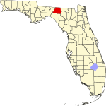 | |
| Towns | ||
| Unincorporated communities | ||