Abstract
The Aristarchus plateau represents one of the most complex volcanic provinces on the lunar surface and is host to the largest pyroclastic deposit on the Moon. Lunar pyroclastic deposits offer a window into the Moon's interior and represent a valuable resource to support a sustained human presence. We present a new analysis of the Aristarchus pyroclastic deposit using Mini-RF bistatic radar data at wavelengths of 4.2 and 12.6 cm. Building on previous Earth-based Arecibo Observatory radar studies at 12.6 and 70 cm, we place further constraints on the spatial extent of the pyroclastic deposit and investigate the clast size distribution and provenance of foreign material distributed within the formation. Concentrations of blocky material >0.5 cm in diameter and suspended within the upper decimeters of the pyroclastic deposit are associated with potential buried mare flows along the rim of Vallis Schröteri and discrete pockets of primary material ejected by the Aristarchus impact. Unraveling the deposit from nonpyroclastic materials and the surrounding landscape creates new constraints with which to reconstruct the volcanic history of the region. From a future mission perspective, the identification of primary Aristarchus material distributed across the plateau offers an opportunity to sample diverse volcanic lithologies within an area that could be sampled by a single Commercial Lunar Payload Services mission. In terms of lunar resource in situ utilization, such ejected material also represents a contaminant; thus, radar data provide an invaluable tool to identify pristine pyroclastic material for mission planners.
Export citation and abstract BibTeX RIS
Original content from this work may be used under the terms of the Creative Commons Attribution 4.0 licence. Any further distribution of this work must maintain attribution to the author(s) and the title of the work, journal citation and DOI.
1. Introduction
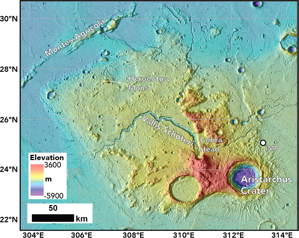
The Aristarchus plateau on the lunar nearside hosts a uniquely diverse assemblage of volcanic features (Figure 1). The most prominent evidence of volcanism is the extensive pyroclastic deposit that mantles the entirety of the plateau and represents the largest such deposit on the Moon (Gaddis et al. 2003). Lunar pyroclastic materials are the products of explosive volcanic eruptions of gas-rich magmas and represent an early phase of lunar volcanism (e.g., Head 1974; Head & Wilson 1981). Explosive volcanism was not the only eruptive style experienced across the Aristarchus plateau, however. Multiple sinuous rilles (including the prominent Vallis Schröteri; see Figure 1) demonstrate that effusive, basaltic eruptions more typical of the maria (the most dominant form of volcanism through lunar history) also occurred. Examples of intrusive and extrusive silicic volcanism (Glotch et al. 2010) are also present, as is a possibly very young (∼100 Ma), small irregular mare patch (IMP; Braden et al. 2014). Surrounding the plateau are the flood basalts of Oceanus Procellarum, which, with the possible exception of the enigmatic IMPs, include the youngest volcanic flows identified on the Moon (unit P60 in Hiesinger et al. 2003).
Figure 1. Elevation and hillshade context map of the Aristarchus plateau highlighting the main geologic features of interest. Topographic products derived from LOLA—SELENE Kaguya 512 global DTM (Barker et al. 2016).
Download figure:
Standard image High-resolution imageCollectively, the Aristarchus plateau region preserves a full spectrum of eruptive styles and compositions that spans the history of lunar volcanic activity. Due to the nearly ubiquitous distribution of the pyroclastic deposit across the plateau, characterizing its extent and stratigraphy relative to the other volcanic features is essential to understanding the history of volcanism within this special region.
Lunar pyroclastic deposits, more generally referred to as dark mantle deposits (DMDs), including those that mantle the Aristarchus plateau, are composed of fine-grained, quenched crystal and glass beads that have high concentrations of iron oxides. Indeed, the high percentage of Fe within the Aristarchus pyroclastic deposit (Lucey et al. 1986; Weitz et al. 1998) gives the plateau a distinct red hue in visible wavelengths that has been noted by astronomers for centuries (e.g., Hevelius 1647; Wood 1912). Analyses of returned Apollo samples have revealed coatings of vapor-deposited volatiles on the surface of pyroclastic beads (McCubbin 2015). Recent remote-sensing studies also indicate concentrations of indigenous water within pyroclastic deposits, including the Aristarchus unit (Li & Milliken 2017; see also Glotch et al. 2021).
Due to the potential deep mantle source of pyroclastic materials, the deposits provide a window into lunar magmatic evolution and important constraints on the initial phase of lunar volcanism. Due to their unique composition relative to other lunar volcanic materials, pyroclastic deposits also represent a potentially valuable resource for future human exploration. Pyroclastic deposits could represent sources of water (Li & Milliken 2017), iron (e.g., Allen et al. 2012) and oxygen (Allen et al. 1996), as well as volatile-element compounds (McCubbin 2015). Identifying pristine regions of the Aristarchus plateau is therefore key to landing site support for future missions from both a scientific and an in situ resource utilization (ISRU) perspective.
Earth-based radar observations represent an important tool in the study of the Aristarchus plateau pyroclastic deposit (Thompson 1974; Zisk et al. 1974, 1977; Gaddis et al. 1985; Campbell et al. 2008). Analysis of radar images at multiple wavelengths placed constraints on the nature and thickness of the deposits, as well as identifying blocky material within the deposit that represents—from a sample collection and ISRU point of view—a source of contamination (Campbell et al. 2008). Here we build on previous radar studies to provide a new perspective of the Aristarchus plateau through analysis of recently collected bistatic data by the Mini-RF radar on the Lunar Reconnaissance Orbiter (LRO). Drawing on the wealth of orbital data available, we also propose landing sites for future robotic or human missions.
2. Previous Earth-based Radar Studies of the Aristarchus Plateau
Initial kilometer-resolution Earth-based radar maps of the lunar nearside at the X (3.8 cm) and P (70 cm) bands using the Haystack (Zisk et al. 1974) and Arecibo (Thompson 1974) observatories, respectively, revealed the Aristarchus plateau to be "radar-dark" relative to the surrounding mare. Reduced radar backscatter is a common signature of lunar pyroclastic deposits due to a deficit of rocks within the corresponding mantling unit (Zisk et al. 1977; Gaddis et al. 1985). Apollo 17 samples of pyroclastic materials (orange soil found at the rim of Shorty crater) revealed grain size distributions of 2–500 μm (Meyer 2010). Such fine particle sizes are orders of magnitude smaller than imaging radar wavelengths, so there is minimal scattering from the smooth surface or the rock-poor volume.
Higher-resolution, multilook Earth-based S- (12.6 cm) and P-band (70 cm) radar images obtained after Arecibo Observatory upgrades in the late 1990s (and the availability of the Green Bank Telescope for dual-polarization mapping) revealed the structure of the Aristarchus pyroclastic deposit in much greater detail (Campbell et al. 2008). These radar data were collected by transmitting from Arecibo Observatory and collecting the returned signal at the 105 m Green Bank Telescope in West Virginia (Campbell et al. 2007).
Echoes in the opposite sense of circular polarization (OC) from that transmitted are typically linked with mirrorlike reflections from smooth surface facets (at the radar wavelength scale). More complex scattering regimes associated with echoes from wavelength-scale blocks on the surface and embedded within the regolith create strong returns in both the OC and the same-sense circular (SC) polarizations. Multilook P- and S-band images for large regions of the nearside were delivered to the Planetary Data System with spatial resolutions of 400 and 80 m, respectively. More limited S-band maps with resolutions as fine as 25 m were also acquired.
Campbell et al. (2008) used SC coverage to identify blocky material within the Aristarchus pyroclastic deposit. Their results supported earlier interpretations (Zisk et al. 1977; Weitz et al. 1998) that mare flows are present on the surface of the plateau but buried by the pyroclastic mantle. The P-band data revealed that these mare units extend broadly from the margins of Vallis Schröteri into the center of the plateau, suggesting that the flows represent overspill from a period when the rille served as an active conduit for lava. Leveraging the higher spatial resolution of the S-band data, the thickness of the pyroclastic deposit over the interplateau mare was constrained to <20 m by identifying the smallest-diameter impact craters to have excavated blocky material from below the fine-grained mantle. Focusing on the pyroclastic materials as a potential resource for future human missions, Campbell et al. (2008) also identified blocky material across the plateau associated with ejecta from the Aristarchus crater impact. The increased backscatter, relative to the pyroclastic deposit as a whole, was only observed in the S-band data, suggesting that the associated rocky material was >2 cm but likely less than ∼10 cm in diameter. This variation in scattering behaviors across the pyroclastic deposit demonstrates the importance of conducting multiwavelength observations of the Aristarchus plateau.
3. Mini-RF Bistatic Experiment
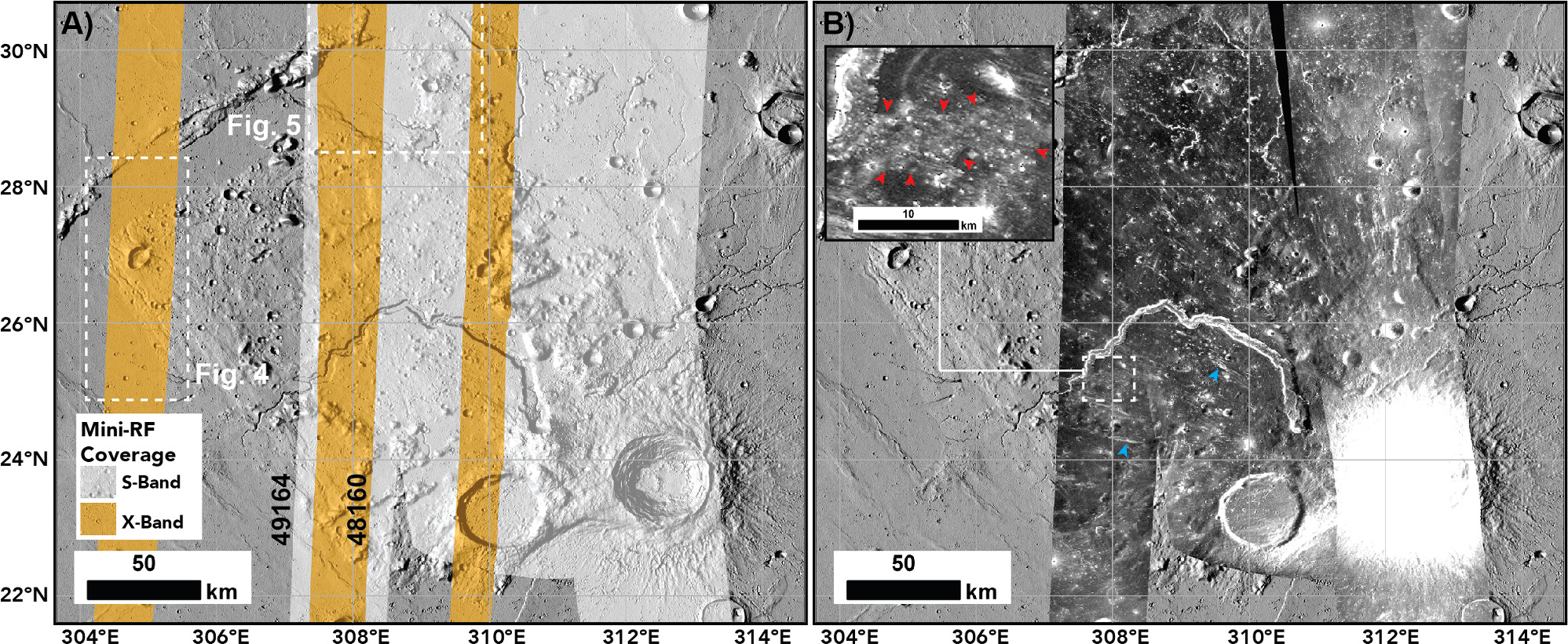
Mini-RF is a hybrid-polarized, dual-frequency synthetic aperture radar that operates at wavelengths of 12.6 cm (S-band) and 4.2 cm (X/C-band; though note that we will refer to this as X-band in the remainder of the text) and was designed as a monostatic radar system; i.e., the antenna operated as both transmitter and receiver. In 2010 December, the transmitter experienced a malfunction and ceased to operate, precluding further monostatic data collection. Fortunately, through leveraging ground station assets, Mini-RF was able to return to science as a bistatic experiment in 2012. The 305 m Arecibo Observatory in Puerto Rico and the Goldstone deep-space communications complex 34 m antenna DSS-13 in California have both been used for S- and X-band transmits, respectively. For each observation, a targeted portion of the lunar nearside is illuminated with a circularly polarized, chirped signal that tracks the Mini-RF antenna boresight intercept on the surface of the Moon. The Mini-RF receiver operates continuously and separately receives the horizontal and vertical polarization components of the signal backscattered from the lunar surface. The two polarization components enable the calculation of the Stokes parameters (for example, Figure 2 shows the first Stokes parameter, which corresponds to the total intensity of the returned echo). The other Stokes parameters can be used to derive the response in both SC and OC and thus the circular polarization ratio (see Patterson et al. 2017). The azimuth resolution of the processed data is 2 m, and the range resolution varies as a function of observation geometry but is ∼100 m. For analysis, the data are averaged in azimuth to provide a spatial resolution of 100 m.
Figure 2. (a) Bistatic radar coverage of the Aristarchus plateau at the S and X bands. White dashed boxes provide the locations of Figures 4 and 5. (b) Bistatic S1 S-band mosaic of the plateau. Note how the extensive pyroclastic deposit results in low radar backscatter across most of the plateau. The red arrows in the inset highlight a region of relatively enhanced backscatter. Blue arrows highlight radar-bright linear facies. An individual stretch has been applied to each radar image to emphasize details within the pyroclastic deposits, which has resulted in some portions of the Aristarchus crater/ejecta to appear saturated. Orbit numbers are listed for the data shown in Figure 3. The background is hillshade derived from LOLA—SELENE Kaguya 512 global DTM (Barker et al. 2016).
Download figure:
Standard image High-resolution imageThe S-band bistatic experiments ceased in 2020 with the collapse of the main Arecibo dish, though X-band Mini-RF bistatic observations are ongoing using the Goldstone system. Nevertheless, prior to the demise of the Arecibo dish, extensive S-band data were collected over the Aristarchus region, enabling the formation of a radar image mosaic of the central region of the plateau (Figure 2). As both Mini-RF bistatic observations and Campbell et al. (2008) used Arecibo transmissions for their S-band collects, to avoid confusion for the reader, we use the term "Earth-based" when referring to the data sets analyzed by Campbell et al. (2008).
4. Mini-RF Data Analysis of Aristarchus Pyroclastic Deposit
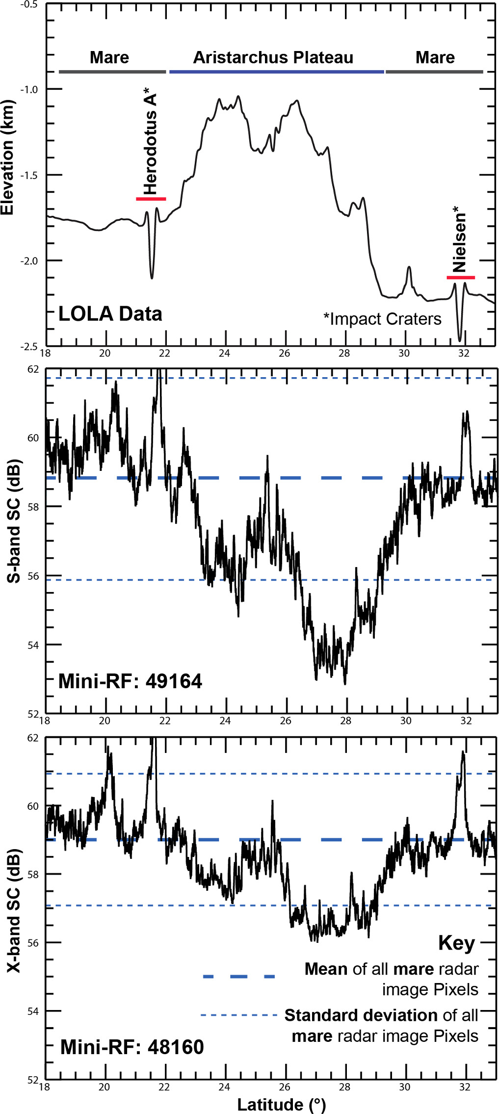
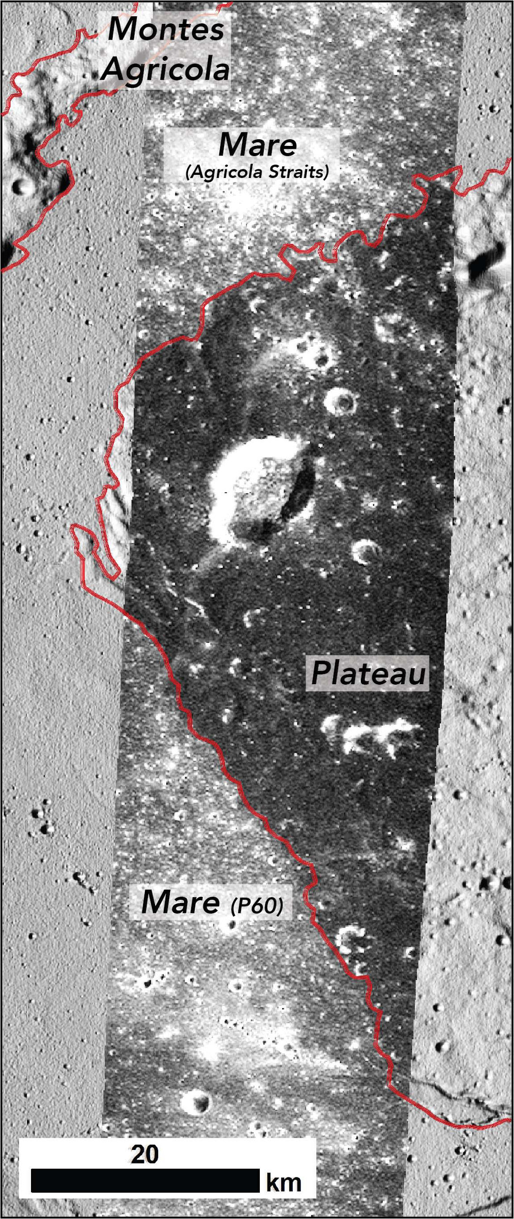
Consistent with previous radar studies of the Aristarchus plateau and other lunar DMDs (e.g., Carter et al. 2009), the majority of the plateau exhibits low backscatter in both the S- and X-band Mini-RF SC data sets (Figures 2–4). The low backscatter of the plateau surface contrasts dramatically with that of the surrounding mare units of Oceanus Procellarum. Relative backscatter intensity values (within individual radar images) from the plateau are up to 5 and 3 dB lower than the average values for the mare at the S and X bands, respectively (Figure 3). The transition zone between the low-backscatter region of the DMD and the brighter mare units delineates a well-defined boundary that can be traced in both wavelengths. To the west and northwest, the perimeter of the low-backscatter region is particularly sharp and clearly aligns with the boundary between the plateau's edge and the adjacent mare (Figure 4). Farther to the northeast, however, low backscatter values are recorded beyond the plateau's escarpment and extend >10 km onto the mare within the eastern section of the Agricola Straits (Figure 5; Zisk et al. 1977).
Figure 3. Comparisons between radar SC backscatter (total intensity of the received field) and (top) topography (middle) at the S (bottom) and X bands. The SC backscatter plots were derived from individual overlapping radar images. The blue dashed lines highlight the mean and one standard deviation value from the mean for all SC image pixels acquired over the mare for each radar image. Note that the region of elevated topography associated with the Aristarchus plateau surface corresponds to lower radar backscatter values due to the presence of the pyroclastic deposit. In comparison, impact craters within the mare display elevated backscatter values due to the presence of blocky material within the crater walls and ejecta blankets. Each backscatter plot was produced from a single Mini-RF radar image (see image location in Figure 2) by conducting a cross-track averaging of pixel values, which consolidated the 2D image arrays into single column arrays representing the mean backscatter intensity at each along-track latitude point. The topographic data represent an equivalent averaging approach for LOLA DTM elevation data extracted from within the S-band Mini-RF image footprint.
Download figure:
Standard image High-resolution imageFigure 4. X-band SC coverage of the western edge of the Aristarchus plateau. Note the sharp transition in backscatter between the (radar-dark) pyroclastic deposit situated on the plateau surface and the relatively radar-bright mare. The red line indicates the extent of the mare (as mapped by Nelson et al. 2014).
Download figure:
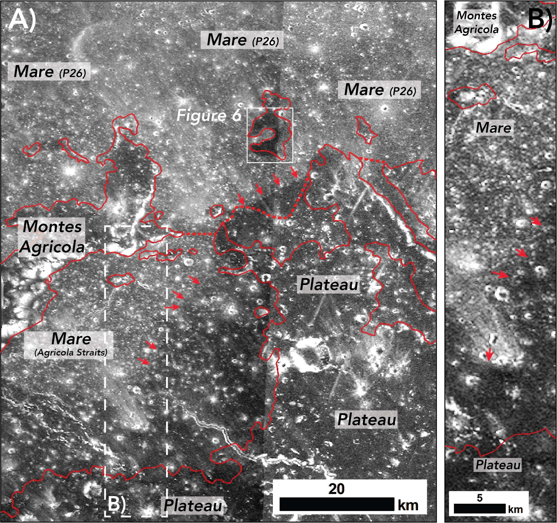
Standard image High-resolution imageFigure 5. S-band (a) and X-band (b) SC coverage of the northern edge of the Aristarchus plateau and the eastern extent of the Montes Agricola. The red arrows highlight the terminal extent of the (radar-dark) pyroclastic deposit that mantles portions of the mare within the Agricola Straits. The solid red lines mark the boundary of the Procellarum mare (Nelson et al. 2014). The dashed red lines mark the southern boundary of mare unit P26 (everywhere north of these lines, the unit is broadly consistent with the solid red mare boundary line).
Download figure:
Standard image High-resolution imageDespite the well-defined boundaries of the Aristarchus low-backscatter zone, distinct variations in the radar echo strength across the plateau surface are apparent in the Mini-RF data. For example, a prominent region of relatively elevated backscatter is situated within the center of the plateau. The anomalously bright returns (multiple dB above the surrounding terrain) are apparent at both wavelengths and can be traced extending from the southern rim of Vallis Schröteri for ∼20 km in a southeastern direction (red arrows in Figure 2(b)). This pattern of backscatter spatially correlates with the Earth-based S-band response highlighted by Campbell et al. (2008), though the bright radar region to the north of Vallis Schröteri identified exclusively in their P-band data analysis does not have an equivalent response in the Mini-RF S- or X-band data. As described above, Campbell et al. (2008) interpreted the radar-bright regions as being due to the presence of mare flows underlying a locally thin section of the pyroclastic deposit.
The low-backscatter zone is also punctuated with numerous radar-bright linear facies. The pronounced bright facies are >5 km long and range in width from multiple pixels (i.e., >100 m) to over 1.5 km (blue arrows in Figure 2). Where equivalent coverage exists, the features are spatially correlated in position and scale within the Mini-RF/Earth-based S-band and Mini-RF X-band images. The features are typically ∼5 and 3 dB brighter than the adjacent terrain in the S and X bands, respectively. The relative brightness of the features is lower in the X band when compared to the S-band return. Linear bright facies (of any scale or position) are not apparent in the Earth-based P-band data (Campbell et al. 2008). The orientations of the radar-bright linear facies converge on the center of Aristarchus crater, suggesting that they were formed during the initial impact event. These features were described in the S-band analysis of Campbell et al. (2008), who attributed their origin to blocky material associated with the Aristarchus impact event.
5. Discussion
As expected from their similar illumination geometry, the Mini-RF S-band radar images are analogous to the Campbell et al. (2008) S-band maps. The Mini-RF X-band data, however, provide new constraints on the physical nature of the Aristarchus pyroclastic deposit that can be contrasted with the longer-wavelength S- and P-band maps. Below, we explore these new insights and incorporate other LRO data sets that were not available at the time of the Campbell et al. (2008) study. Specifically, we focus on the spatial extent of the blanket, the buried mare flows, and the radar-bright Aristarchus distal ejecta features. Drawing on this integration of radar images with other orbital data sets, we discuss potential landing sites across the plateau based on scientific and ISRU considerations.
5.1. Spatial Extent of the Pyroclastic Deposit
Quantifying the scale of the explosive eruptions responsible for the Aristarchus pyroclastic deposit and the volume of the associated resources requires accurate knowledge of the spatial extent of the blanket. Such mapping efforts are also important because they enable the stratigraphy of the deposits relative to other units to be established, which in turn provides insights into the timing of the eruptions. Spectral maps based on specific mineral abundances (e.g., TiO2; Lucey et al. 2000) or derived from the absorption properties of various mafic assemblages have been applied to map out lunar DMDs, including Aristarchus (Weitz et al. 1998; Gaddis et al. 2003; Lough 2011). Due to the micrometer penetration of UV–NIR wavelengths, the corresponding mapping is susceptible to impact gardening–based mixing, which can distort the unit boundaries. The mafic composition of the mare surrounding the plateau can also hinder mapping efforts, as it can be difficult to distinguish from the pyroclastic materials in spectroscopic analyses (Weitz et al. 1998). Due to their longer wavelengths that ignore tiny regolith inclusions and their far deeper signal penetration relative to UV–NIR data sets, radar echoes are less susceptible to mixing and contamination from distal ejecta (e.g., Campbell et al. 2014) and thus offer a complementary (e.g., spatially sharper) means to map the boundaries of pyroclastic deposits.
Our analysis of the radar data reveals an abrupt termination of the low-backscatter signature at all wavelengths along the boundary where the Procellarum mare flows embay the western and northwestern plateau flanks (Figure 4). This distinct contrast in radar return was also noted by Campbell et al. (2008) and suggests that these mare flows postdate the emplacement of the pyroclastic deposit. Dating efforts have identified that the flows to the west of the plateau constitute the youngest mare surfaces on the Moon (excluding the potentially young age of the IMPs). This region of Oceanus Procellarum is defined as unit P60 in the Hiesinger et al. (2003) survey, with a corresponding age estimate of 1.2 Ga corroborated by higher-resolution crater size–frequency surveys by Stadermann et al. (2018).
To the north of the plateau, the two Mini-RF wavelengths, as well as the Earth-based S-band data presented by Campbell et al. (2008), suggest a more complex relationship between the pyroclastic deposit and the mare (note that the lower spatial resolution of the P-band data, 400 m pixel−1, relative to the other radar data sets makes it difficult to resolve the margin of the pyroclastic deposit relative to the mare). The low-backscatter signature extends beyond the plateau flanks and onto the surface of the mare flows between the plateau and Montes Agricola (marking the eastern portion of the Agricola Straits). Figure 5 shows the Mini-RF S- and X-band coverage of this region, where low backscatter values (relative to those returned from the mare as a whole) are concentrated to the south and east of the mare units (as mapped by Nelson et al. 2014 using LROC data), suggesting that the pyroclastic blanket extends beyond the plateau surface in this region and thus sits stratigraphically above the mare flows. It therefore appears that this region of the mare was emplaced prior to at least the final phase of pyroclastic eruptions.
The mare within the Agricola Straits was not dated by Hiesinger et al. (2003), and no subsequent age estimates have been presented in the literature. Where we observe the pyroclastic deposit to extend beyond the plateau's northern flank, the nearest dated mare unit is situated directly north of Montes Agricola (P26) and has an age estimate of 3 Ga (Hiesinger et al. 2003; Figure 5), making it the second-oldest mare surface in the immediate region (though Morota et al. 2011 argued for a younger age). Interestingly, the pyroclastic material appears to terminate close to the southern boundary of unit P26, suggesting that flows comprising this unit embayed the pyroclastics. If this interpretation is correct, it pushes the age of the explosive eruptions to >3 Ga.
Our radar-based survey also helps to reconcile discrepancies in previous mapping efforts based on other remote-sensing data sets. For example, the Wilhelms & McCauley (1971) and Lough (2011) maps show the dark mantling unit as restricted to the Aristarchus plateau surface, whereas Weitz et al. (1998) considered the pyroclastic deposit to extend north of the plateau and throughout the whole of the Agricola Straits. Based on our analysis, the radar data suggest that the pyroclastic deposit does indeed extend beyond the plateau surface to the north but only mantles portions of the eastern edge of the Straits.
Recent analysis of Moon Mineralogy Mapper (M3) hyperspectral VNIR data by Glotch et al. (2021) supports our radar-based interpretations of mare/pyroclastic deposit stratigraphy. Application of the Li & Milliken (2017) methodology to map pyroclastic deposit water content from the M3 3 μm band shows water contents up to several hundred parts per million within the eastern portion of the Agricola Straits, suggesting a high concentration of pyroclastic material (see Figure 6 in Glotch et al. 2021). Their analysis also did not identify water in the western portion of the Agricola Straits, consistent with the radar results presented here (Figure 4).
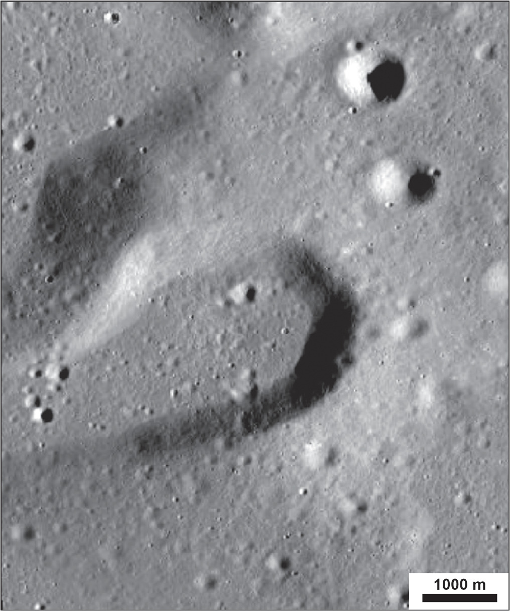
Directly north of the furthest extent of the pyroclastic blanket, a 5 km wide isolated patch of elevated terrain, relative to the surrounding mare, also exhibits low S-band SC backscatter (Figure 5). Based on mare boundary mapping efforts by Nelson et al. (2014), this high-standing terrain has been embayed by mare flows in a similar manner to Montes Agricola directly to the west. However, the morphology of the unit in question is distinct from that of Montes Agricola in that it forms a broadly conical shape with a central crater that has been breached along the western flank (Figure 6). The form and scale of the feature is similar to volcanic cones in the Marius Hills, Mare Serenitatis (Lawrence et al. 2013), and Mare Crisium (Lu et al. 2021). Under the Lawrence et al. (2013) classification scheme, the prominence of the breached crater makes this feature a C-class (e.g., C-shaped) cone. The summit diameter (DS) to base diameter (DB) ratio of 0.54 is also within the range of DS/DB values of C-class cones from Lawrence et al. (2013), which range from 0.2 to 0.78. Such cones are analogous to terrestrial cinder or composite volcanic cones. The low SC backscatter return from the slopes of the cone is consistent with fine-grained pyroclastic material, suggesting that the cone formed at least in part by an explosive eruption and may have been an additional source of pyroclastic material near the Aristarchus plateau.
Figure 6. LROC NAC mosaic of the potential C-class cone north of the Aristarchus plateau (see Figure 5 for location).
Download figure:
Standard image High-resolution imageDue to the stratigraphic relationship with the surrounding mare, any explosive eruptions associated with the potential volcanic cone must have concluded prior to the most recent phase of mare formation, similar to the relative age of the Aristarchus pyroclastic deposit discussed above. The cone is embayed by the Hiesinger et al. (2003) P26 unit, suggesting that its formation occurred prior to 3 Ga. The identification of this new volcanic cone further emphasizes the extensive period of explosive volcanic activity on and near the Aristarchus plateau. Alternatively, the potential pyroclastic materials on the cone could represent a remnant of the northern extent of the greater Aristarchus plateau blanket that was preserved from embayment by the P26 mare unit due to being deposited on high-standing terrain. Regardless, the position of the cone close to the plateau margin and its distinct volcanic morphology argue that it formed as part of the concentrated volcanic activity associated with the Aristarchus plateau.
5.2. Buried Mare Flows
The presence of interplateau mare flow units underlying locally shallow portions of the pyroclastic blanket as documented by Campbell et al. (2008) have important science and ISRU ramifications. From a lunar volcanology standpoint, the detections of basaltic units argue that effusive eruptions accompanied or predated phases of explosive activity. Campbell et al. (2008) suggested that the flows represented overspill from Vallis Schröteri. If so, lava within the rille would have had to achieve bank-full levels, which places important constraints on the flow regime and the formation of the channel (e.g., Jaeger et al. 2010).
From an ISRU perspective, buried mare units pose a source of contamination for future resource harvesting efforts. Campbell et al. (2008) interpreted the elevated backscatter observed in the Earth-based data as the result of material excavated by impacts penetrating through the deposit and into the upper surface of an underlying, coherent unit of mare flows. The rationale is that if the pyroclastic deposit is locally thinner within the plateau center, relatively smaller—and thus more numerous—impacts will penetrate the deposit to excavate the mare below. Such excavated material will, in effect, dilute the pyroclastic material, reducing, for example, the volume of water that could be extracted from a given area. Indeed, due to the presence of a thin surficial layer of Aristarchus ejecta across much of the southern portion of the plateau, it is not possible to make water content estimates from spectral analysis (see Li & Milliken 2017). Therefore, the radar provides valuable insights into the heterogeneous nature of the pyroclastic deposits over the upper meter.
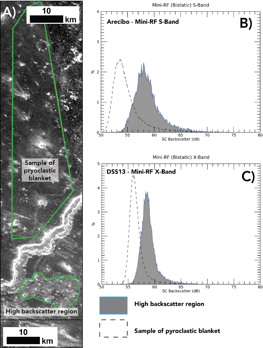
As a test of buried mare contamination, we extracted X- and S-band pixel values from the anomalously bright region and compared the backscatter values to an area of the plateau in which the pyroclastic deposit is thicker. The Campbell et al. (2008) analysis identified the pyroclastic deposit north of Vallis Schröteri as the deepest (>20 m) and least contaminated in terms of blocky material. Outlining a sample area north of the rille (Figure 7), a comparison across the radar-bright region yields an ∼4 and ∼2.5 dB relative difference in the backscatter value at the S and X bands, respectively. Figure 7 displays the backscatter distributions of the two sample areas at each wavelength, demonstrating the enhancement of the radar signal from south of Vallis Schröteri relative to that to the north. The difference between the two sample regions is also more pronounced in the S band relative to the shorter-wavelength X-band data.
Figure 7. (a) S-band SC coverage of the central portion of Aristarchus plateau highlighting the radar-bright feature within the low-backscatter zone directly south of Vallis Schröteri. (b) Distribution of S-band SC backscatter (total intensity of the received field) values from the radar-bright region relative to backscatter values extracted from north of Vallis Schröteri. (c) Equivalent backscatter plots for the X-band SC data.
Download figure:
Standard image High-resolution imageThe Mini-RF results support the Campbell et al. (2008) interpretation that the radar-bright regions contain concentrations of blocky material excavated from a shallow coherent unit (such as a buried lava flow). The enhanced X-band backscatter observed over the same region as the S-band data places further constraints on the scale and vertical placement of the blocky material relative to the earlier S- and P-band analysis. The elevated X-band response argues that the blocky material includes clasts >0.5 cm in diameter that are situated within the upper tens of centimeters of the pyroclastic deposit that occupies the central region of the plateau. The relatively higher backscatter enhancement of the S band relative to the X-band return further suggests that the concentration of blocky material increases with depth. A similar argument also applies to the region east of Vallis Schröteri, where only the longest-wavelength (and thus deepest-penetrating) P-band data, as reported by Campbell et al. (2008), record an increase in backscatter. The lack of enhanced backscatter in the two shorter wavelengths likely indicates that the blocky material in this region of the plateau is situated at depths of >1 m within the regolith column. Impact gardening processes that homogenized the rock population within the upper meter might be partially responsible for the lower response at the X and S bands.
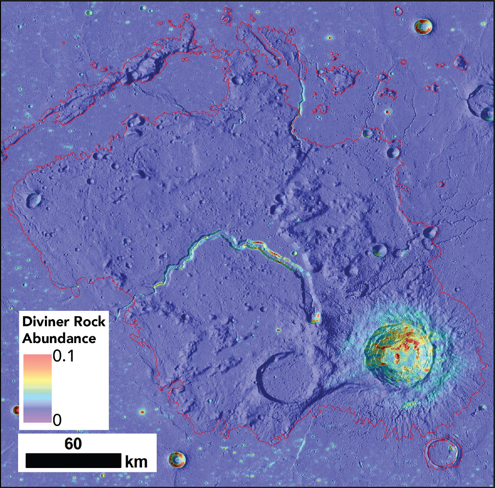
To further explore the potential of buried mare flows providing a supply of blocky material to the near surface of the DMD, we compared the radar data to other orbital data sets. The Diviner rock abundance values come from a dual-component thermal model of the lunar surface anisothermality that results from the presence of rocks and regolith in a given field of view (Bandfield et al. 2011). Rock abundance data represent the percentage of rocks at the lunar surface that are similar in diameter to the lunar thermal skin depth (∼1 m). This data set reveals the plateau as a whole to be largely free of rocks (Figure 8). Only Aristarchus crater, a few small fresh craters, and the inner flanks of Vallis Schröteri exhibit high rock abundance values, likely associated with impact and mass wasting processes. The elevated regions of high radar backscatter highlighted in Figure 7 and Campbell et al. (2008) do not correspond to equivalent increases in the Diviner 1 m shallow rock abundance. In agreement with the Diviner data, LROC Narrow Angle Camera (NA) images also reveal a paucity of surface rocks in the regions of elevated backscatter (Bandfield et al. 2011; Cahill et al. 2014). This again suggests that the radar response is caused by rocks or breccias buried within the probing depth of the radar signals (considered to be ∼10 times the wavelength).
Figure 8. Diviner rock abundance over the Aristarchus plateau and surrounding mare. Note the lack of rocks across the majority of the plateau, with the exception of Aristarchus crater, Vallis Schröteri, and a few fresh craters. Data product derived by Bandfield et al. (2011). The red line represents the boundary of the mare as mapped by Nelson et al. (2014). The background data are a hillshade image derived from LOLA—SELENE Kaguya 512 global DTM (Barker et al. 2016).
Download figure:
Standard image High-resolution image5.3. Aristarchus Ejecta
The 40 km diameter Aristarchus crater represents the last major event to shape the plateau. Formed during the Copernican period, the impact occurred on the southeastern portion of the preexisting pyroclastic deposit and emplaced ejecta across the plateau. Aristarchus crater–related material therefore represents an important stratigraphic marker with which to frame the geologic history of the plateau. The Aristarchus impact event also greatly modified regions of the pyroclastic deposit, diluting their ISRU potential and increasing the landing/trafficability risks of these areas.
The radar-bright facies identified in the Earth-based and Mini-RF data (Figures 2(b) and 9) offer a means to explore the distal influence of the Aristarchus impact on the pyroclastic deposit (beyond the main ejecta blanket). The contrasting response of the P band relative to the shorter radar wavelengths places constraints on the scale of the clasts responsible for the bright returns and their depth within the regolith. None of the linear radar-bright features observable in the X/S-band radar images are apparent within the P-band data of Campbell et al. (2008). This holds for even the broadest and longest lineations (>1 km wide and multiple kilometers in length), suggesting that the lack of signal in the longest-wavelength data is not a spatial resolution issue (P-band images have a resolution of 400 m). In fact, the P-band data are sensitive to block-rich, fresh impact craters only hundreds of meters in diameter, so the wavelength dependence is likely modulated by the diameter of the blocks in the ejecta rather than the scale of the areas disturbed by the Aristarchus impact. This suggests that the typical clast size within the ejecta in the radar-bright facies is <10 cm in diameter. The material must also be present in the upper tens of centimeters of penetration depth of the Mini-RF X-band signals.
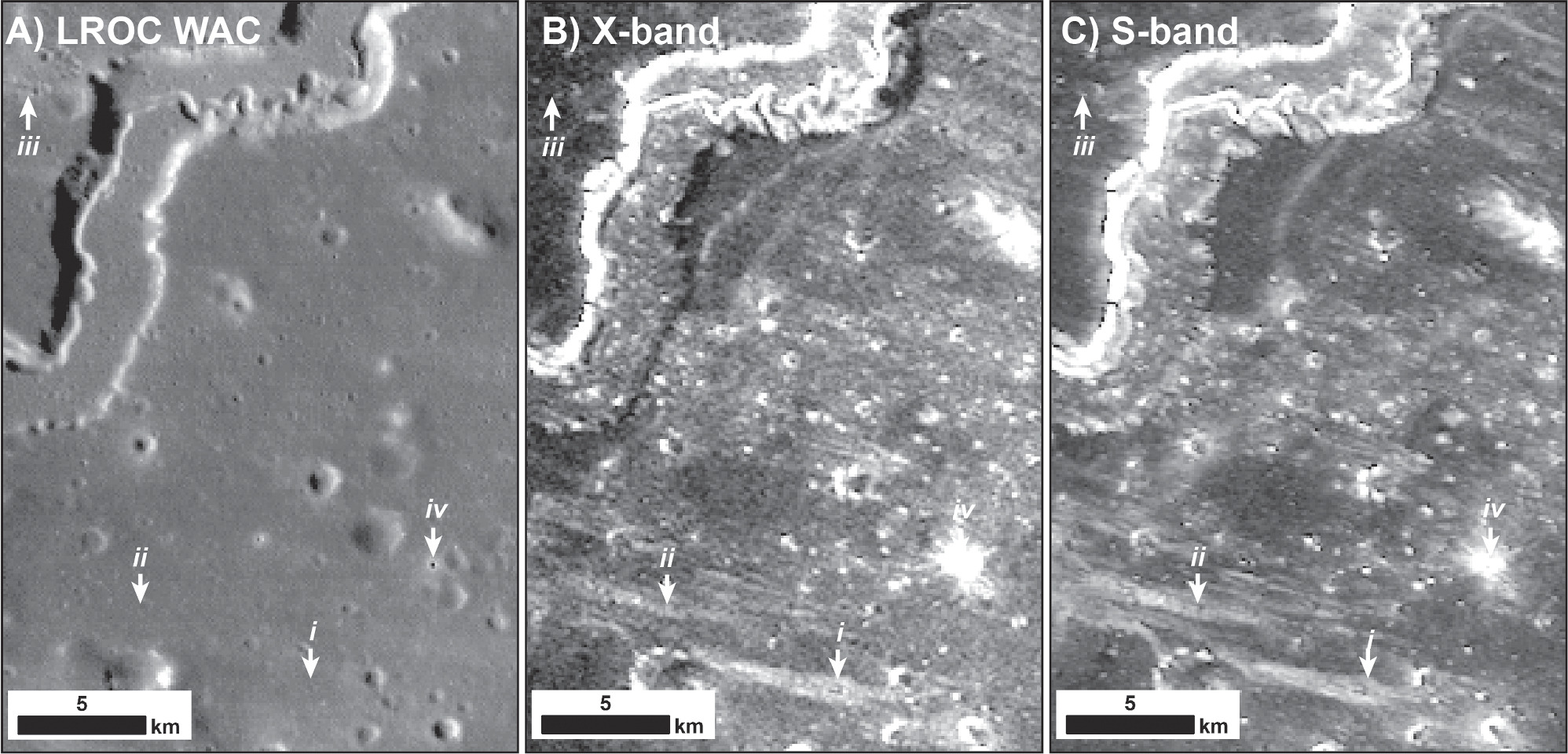
Figure 9. (a) LROC WAC image of the central portion of Aristarchus plateau highlighting apparent impact-related features (i–iv). Also shown are the equivalent X-band (b) and S-band (c) SC image data. Features i and ii are examples of radar-bright linear facies. Feature iii is a secondary crater chain radial to Aristarchus crater. Feature iv corresponds to an ∼300 m young primary impact crater.
Download figure:
Standard image High-resolution imageCampbell et al. (2008) argued that the radar-bright linear facies they observed in the Earth-based S-band radar maps represent blocky material either (1) directly ejected by the impact or (2) locally excavated via related secondary impact processes. Interestingly, Campbell et al. (2008) also noted that the radar-bright lineations did not correspond to obvious secondary ejecta features in Lunar Orbiter image data. The lack of correlation suggested that the radar was sensitive to blocky, impact-related material preserved within the shallow subsurface. The presence of secondary structures unresolvable in the 60 m pixel−1 resolution of the Lunar Orbiter images could not, however, be ruled out in 2008. Since then, LRO has provided higher-resolution images and additional data sets to compare to the radar results.
As was the case with the potential buried mare flows (Section 5.2 above), Diviner rock abundance data do not show evidence of elevated rock abundance associated with any of the radar-mapped ejecta features (Figure 8). We interpret this lack of correlation to suggest that much of the blocky material associated with the bright facies is of submeter diameter and/or buried below the surface. The availability of high-resolution LROC data offers another avenue with which to investigate the origin of these ejecta features. Figure 9 shows comparisons between the Mini-RF X- and S-band SC data and equivalent LROC coverage. None of the radar-bright linear features (labeled i–ii in Figure 9) correspond to any obvious small (i.e., secondary) impact structures. In contrast, secondary chains—oriented orthogonal to the rim of Aristarchus and thus assumed to be caused by the impact—that are present in the LROC data (see feature iii in Figure 9) do not correspond to high-backscatter areas of the Mini-RF radar images.
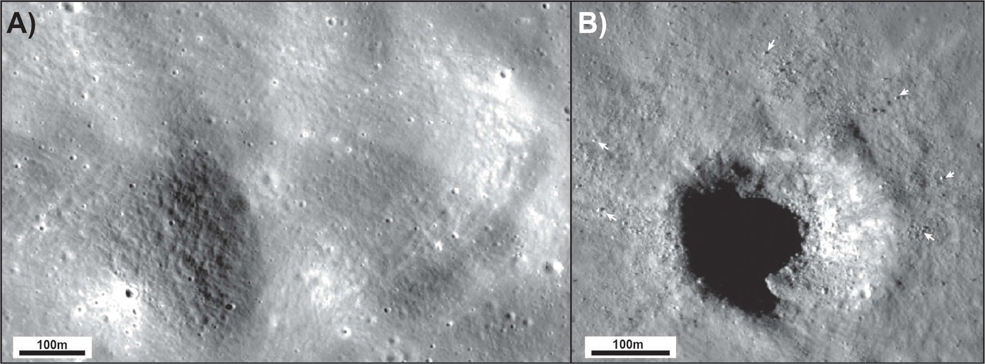
The lack of correlation between LROC and Mini-RF provides important information about the nature of the secondary impacts in deep regional pyroclastic deposits. First, the occurrence of secondary chains without a radar-bright signature suggests that these impacts were insufficient to generate centimeter-scale blocky material beyond that typical of the impact-gardened, pyroclastic-dominated regolith. Further, inspection of the secondary chains shows an absence of rocks (of any scale) on the surface, especially when compared to apparent primary craters of similar diameter that are radar-bright at both wavelengths (Figure 10). Second, radar-bright features with no obvious equivalent impact structures at the LROC NAC scale imply that the blocky material responsible for their enhanced backscatter was not excavated by secondary impacts but instead must represent clusters of primary material of the Aristarchus impact. From an ISRU perspective, these results are important because they demonstrate that visible images, or indeed thermal data (that are limited to probing the upper centimeters of the regolith as dictated by thermal skin depth), cannot be used exclusively to identify regions of near-surface rocks suspended within the upper tens of centimeters to 1 m of pyroclastic deposits.
Figure 10. LROC NAC images of (a) a portion of an apparent Aristarchus secondary chain highlighted as feature iii in Figure 9 and (b) a 300 m diameter primary crater highlighted as feature iv in Figure 9.
Download figure:
Standard image High-resolution image5.4. Landing Site Considerations
Due to the diverse assemblage of volcanic structures in addition to the rich ISRU potential, the Aristarchus plateau represents a high-priority landing site for future missions (Jawin et al. 2019, 2021; Glotch et al. 2021). Landed missions, both robotic and human, could address fundamental lunar science including all four volcanology science goals identified by the Lunar Exploration Analysis Group's Final Report of the Advancing Science of the Moon Specific Action Team, as well as contribute to Question 5 (Solid Body Interiors and Surfaces) of the 2022–2031 Planetary Science and Astrobiology Decadal Survey (National Academies of Sciences, Engineering, and Medicine 2022). The plateau could also potentially support a sustained human presence (Jawin et al. 2021). Applying the insights gained from our radar-based analysis, we revisit the Glotch et al. (2021, 2022) landing site priorities and present additional sites to be considered by the lunar science community. Finally, we discuss the implications of our results for resource extraction by future human missions to the Aristarchus plateau.
5.4.1. Science-focused Landing Sites
Glotch et al. (2021, 2022), as part of their analysis of the Aristarchus plateau, distilled a list of the highest-priority landing sites and argued for a sustained exploration program to capture the full scientific value of the region. To explore the full range of volcanic geochemistry and eruptive styles preserved on the plateau, they argued for landing sites at Aristarchus crater, the Cobra Head of Vallis Schröteri, and the Herodotus Mons volcanic edifice (see Figure 1 for reference).
In regard to Aristarchus crater, the impact appears to have excavated intrusive silicic lithologies suggesting an expansive granitic pluton below the plateau (Glotch et al. 2021). The composition of samples from Aristarchus could therefore be directly compared with granitic material collected during the Apollo missions to expand our understanding of the thermal and petrologic evolution of the broader lunar crust. Due to the apparent homogeneous composition of both the crater floor and immediate ejecta blanket (at Diviner and M3 data spatial scales), Glotch et al. (2021) argued that a static lander anywhere within the impact structure would achieve the science objectives of the site.
In contrast to the intrusive silicic volcanism accessible at Aristarchus plateau, Glotch et al. (2021, 2022) also argued for landing sites at Cobra Head and/or Herodotus Mons to sample extrusive silicic volcanic material. Cobra Head offers an example of potential bimodal volcanism, as it is also the source of the basaltic sinuous rille, though the steep slopes that would need to be traversed to reach the silicic lithology make it a challenging landing site. Glotch et al. (2021) concluded that the margins of Herodotus Mons, in contrast, offer a safer landing zone and the opportunity to access both pyroclastic and silicic material via a mission with mobility capability.
In our assessment of the X- and S-band data presented above, we argue that radar-bright features outside of the overspill region near the rille (Figure 9) represent material ejected directly from the Aristarchus impact distributed within the upper meter of the regolith. If our assessment is correct, landing at a radar-bright, raylike facies anywhere on the pyroclastic deposit would have the added benefit of providing possible silicic material excavated by Aristarchus. Such a landing site would also facilitate the sampling of pyroclastic material, which is absent or badly mixed with ejecta near Aristarchus crater. Indeed, due to the compositional uniformity of Aristarchus crater, as noted by Glotch et al. (2021), the scope of science achieved by landing near the crater would be limited, making the radar-bright features an attractive alternative.
There are no radar-bright linear facies in the vicinity of Cobra Head or Herodotus Mons that would enable both intrusive and extrusive volcanic lithologies to be sampled within the same site. Fortunately, Glotch et al. (2021) presented other locations that exhibit moderate FeO abundances and Christiansen feature positions consistent with silicic materials. In particular, potential silicic volcanic materials occur in hummocky terrain in the southwestern portion of the plateau (Figure 11). This region is also host to radar-bright facies, presenting an opportunity to examine multiple silicic lithologies and pyroclastic materials within a relatively small area.
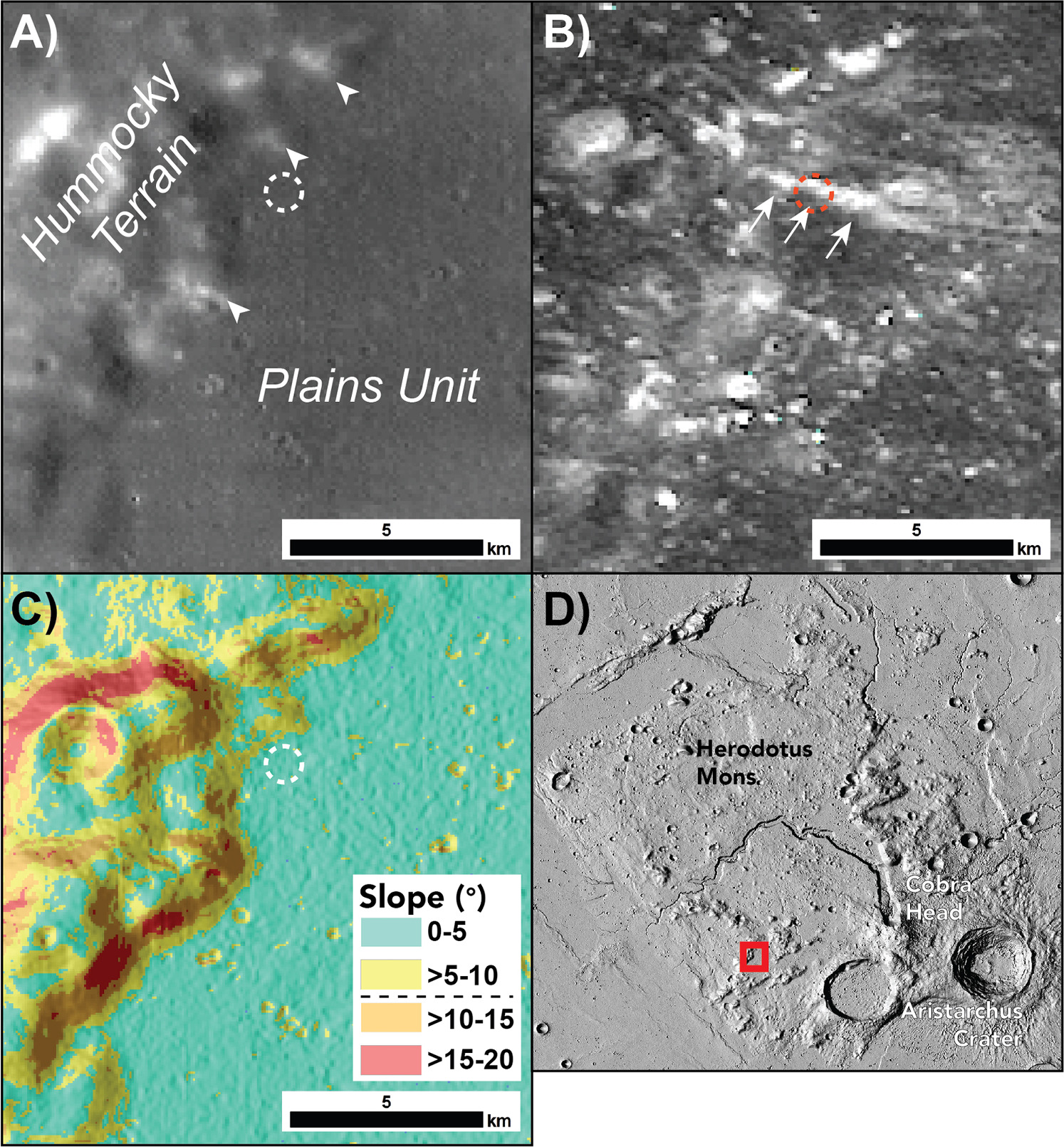
Figure 11. Conceptual CLPS mission landing site within the hummocky terrain of the Aristarchus plateau. (a) LROC WAC image of the landing site (100 m landing ellipse shown as white dashed circle). White arrows point to potential silicic exposures. (b) Mini-RF S-band SC image highlighting a radar-bright feature with white arrows (note the landing ellipse shown as a red dashed circle). (c) Slope data over a hillshade image derived from LOLA—SELENE Kaguya 512 global DTM (Barker et al. 2016). (d) Context image of landing site.
Download figure:
Standard image High-resolution imageCurrently planned Commercial Lunar Payload Services (CLPS) missions with mobility capability, such as the 2026 Gruithuisen Domes mission, anticipate rover traverses of up to 500 m. With similar capabilities, a mission to the hummocky terrain could sample an area with a radar-bright facies of primary Aristarchus material (e.g., intrusive silicics; Glotch et al. 2021), relatively pristine pyroclastic material, and a high-albedo exposure of one of the individual knobs considered to be silicic outcrops. Figure 11 represents a CLPS mission concept to the hummocky terrain. The plains unit between the hummocks is relatively flat (<5° slopes, below the current safety threshold of 10°) and extends for hundreds of meters; thus, it could accommodate proposed CLPS landing ellipses of 100 m. Landing within the ellipse presented in Figure 11 would allow a radar-bright facies to be sampled. Potential silicic material derived from the flanks of the hummocky terrain could also be investigated by a relatively short (∼100 m) traverse from the ellipse center.
Glotch et al. (2021, 2022) did not consider areas of buried mare flows as a potential landing site. Nevertheless, samples of rille-related mare materials likely originating from the same magmatic source as the pyroclastic deposit would be of high scientific value. As is the case with the radar-bright raylike features, given their X-band response, the potential buried units to the south of Vallis Schröteri shown in Figure 7 may be sampled as small rocks within the upper few centimeters. A lander/rover equipped with a scooper arm similar to the Chang'E 5 mission could sample the basalts derived from the buried mare. If the flows do represent overspill from Vallis Schröteri, then such samples would provide insights into the formation of the rille. Determining the crystallization age of the mare material from 40Ar/39Ar radiometric dating through either in situ (e.g., Cohen et al. 2021) or sample return would constrain the age of rille activity and the role of thermal erosion in its formation. Vallis Schröteri also drains into the P60 unit, the youngest broad mare unit to be dated based on crater size–frequency distributions (Hiesinger et al. 2003). As the overspill mare unit is buried by pyroclastic materials and the P60 unit is stratigraphically higher than the pyroclastic deposit, the rille must have been active during multiple phases of eruption in the region over an extended period of time. Nevertheless, due to the range of volcanic lithologies/materials that could be sampled at the hummocky terrain (Figure 11), we favor this as our highest-priority landing site.
5.4.2. Resource-focused Landing Sites
From an ISRU perspective, with an aim of establishing a sustainable lunar outpost on the Aristarchus plateau, the radar data provide essential risk assessment information. Whereas the high-backscatter regions represent important scientific opportunities, they also, as was pointed out by Campbell et al. (2008), indicate the presence of contaminants within the pyroclastic deposit that would need to be removed prior to extracting water and oxides and will add further complications to already challenging excavation scenarios for ISRU techniques currently in development (see Zhang et al. 2023 and references therein). The X-band results are especially important in this regard due their ∼1 m maximum penetration depth and thus correlation with the realistic depth of resource extraction. The good agreement with the S-band data argues that such impurities within the pyroclastic deposit extend throughout the upper meter and deeper still in the case of the buried mare flow regions, where the P-band data also exhibit high backscatter. Based on the apparent vertical distribution of blocky material within the pyroclastic deposit in the high-backscatter regions, it would be nearly impossible to avoid impurities and much larger-grained components during resource extraction.
Collectively, the backscatter response of each of the three wavelengths could be integrated with other data sets, particularly spectral-based products, to derive a type of pyroclastic deposit purity map. Fortunately for future mission planners, the main radar-based contamination zones are relatively well defined and limited to discrete regions of the plateau. The Aristarchus ejecta-related radar-bright features have sharp boundaries that would enable resource extraction and science to occur in close proximity to one another (see Figure 9). Overall, the radar data show that the regions of the plateau north of Vallis Schröteri contain the least contaminated pyroclastic material (Figure 7). Much of this region also exhibits low slopes suitable for landing sites and would be our suggested landing zone for mass resource extraction by future human missions.
6. Conclusions
Evaluating the backscatter returns in recently acquired 4.2–12.6 cm wavelength radar images places new constraints on the nature of the pyroclastic material that mantles the Aristarchus plateau. While the Mini-RF data align well with earlier Earth-based radar studies regarding the presence and origin of foreign material, they provide fresh insights into the clast size and vertical distribution of this material within the pyroclastic blanket. The correlation of S-band echoes with shorter-wavelength X-band returns indicates that the upper centimeters of the near surface in these areas have been significantly reworked and interspersed with nonpyroclastic material that is millimeters–centimeters in diameter. Integrating Mini-RF data with Earth-based and other orbital data sets also allows the origin and timing of such materials to be explored.
Our analysis also provides a means to explore the relative timing of the volcanic events that shaped the Aristarchus plateau. The embayment of the northern extent of the pyroclastic deposits by the P26 mare unit constrains the former's age to >3 Ga. This relationship implies that undated mare units, both south of P26 and within the Agricola Straits (which are mantled by pyroclastic material), also erupted prior to 3 Ga. While the duration and number of pyroclastic eruptions remain uncertain, we suggest that a possible off-plateau source in the form of a volcanic cone is indicative of multiple phases of explosive eruptions.
From a human mission standpoint, our analysis further delineates regions of concern for ISRU. The region of shallow-buried plateau mare flows and the radar-bright linear features represent portions of the pyroclastic deposit contaminated by more coarse-grained material. The lack of equivalent detections in other data sets means the material does not reside on the surface but rather, as the X-band data suggest, is situated at depths of only centimeters to tens of centimeters.
While the radar data highlight areas of caution from an ISRU perspective, our results also show the scientific value of these areas. If the radar-bright facies represent primary material ejected by the Aristarchus impact rather than in situ material excavated by secondary impacts, then scientifically valuable Aristarchus silicic material could be sampled across the plateau. We favor the knobby terrain to the southwest of the plateau as a future landing site for science exploration. This location would enable the sampling of in situ pyroclastic material and extrusive silicic volcanics, as well as potential intrusive silicic lithologies excavated by Aristarchus. Such a mission would finally unravel the long-studied formation processes and stratigraphy of the diverse volcanic features on the Aristarchus plateau.
Acknowledgments
The authors express their gratitude to two anonymous reviewers for their insightful comments and suggestions, which contributed to the enhancement of this manuscript. We also extend our thanks to the entire staff at Arecibo Observatory and the JPL/Goldstone Deep Space Communications Complex/DSS-13 for their invaluable support in acquiring these observations. Special acknowledgment is due to Michael Nolan, Patrick Taylor, Anne Virkki, and Martin Slade for their indispensable roles in the acquisition of the data presented.
