Abstract
Massive hydropower dams in the Mekong river basin (MRB) have triggered substantial debate and international attention due to its utmost importance on maintaining ecology and biodiversity. Although numerous studies have been conducted to assess the consequences of existing and proposed dams, the combined effects of dams on biodiversity and ecosystems have received limited attention. In this study, we focused on the dam's locations and suitability on the overall Mekong River Network in order to comprehend the environmental and ecological integrity of the MRB as a whole. Overall, we identified harmful dams on their associated sub-basins based on the notion of connectivity. The vulnerability of ecosystems and biodiversity in the MRB is well recognized, and our findings generally provide additional theoretical support for their protection.
Original content from this work may be used under the terms of the Creative Commons Attribution 4.0 licence. Any further distribution of this work must maintain attribution to the author(s) and the title of the work, journal citation and DOI.
1. Introduction
The Mekong River basin (MRB) is one of the largest and complex river basins along with its river network systems [1, 2]. Rapid socioeconomic development growth and rising increase in regional energy demands have recently led to an increase in the construction of enormous hydroelectric dams throughout the basin [3, 4]. Specifically, China alone has been recently building dozens of mega dams on the Lancang River [2, 4], which is responsible for the drainage of the upper MRB. Additionally, several large main channel dams have been constructed, and approximately a dozen main channel dams and over one hundred tributary dams have also planned [1, 4, 5]. The new dams and reservoirs are projected to meet fast expanding energy demands and bring other societal purposes, which in turn will trigger multiple socioeconomic and environmental challenges [2, 5–7].
Hydro-dynamically, dams affect natural flow regimes [8] by altering the amplitude, timing, and flow of water along with sediments and nutrients [2, 9–13], which have detrimental effect on the downstream eco-hydrological systems, especially on the river-floodplain ecosystems and their biological integrity [14, 15]. The impacts of flow regulation on the natural regime in the MRB can also be characterized by a unique hydrological flow pattern known as the flood pulse, which supplies water and full of sediments and nutrients to agricultural land, inland fisheries, and instream and wetland ecosystems that are acting as a key feature for life and important ecosystems in the Lower MRB [16, 17]. In addition, flood pulse is the main driver of the Tonle Sap River Basin (TSRB) that discharges water, nutrients and sediments into the Tonle Sap Lake (TSL) during the rainy season and drains water from the lake into the Mekong river during the dry season. Seasonal river-lake inundation dynamics in the vicinity of this lake support one of the world's largest and most profitable freshwater fisheries [18, 19] and provide important ecological and agricultural flow in the Mekong Delta during the dry season [20]. Any changes in the duration, intensity, timing, and speed of the Mekong river flow, as well as the associated floodplain dynamics, can thus result in a severe impact on a wide variety of ecosystems and jeopardize regional food security [17].
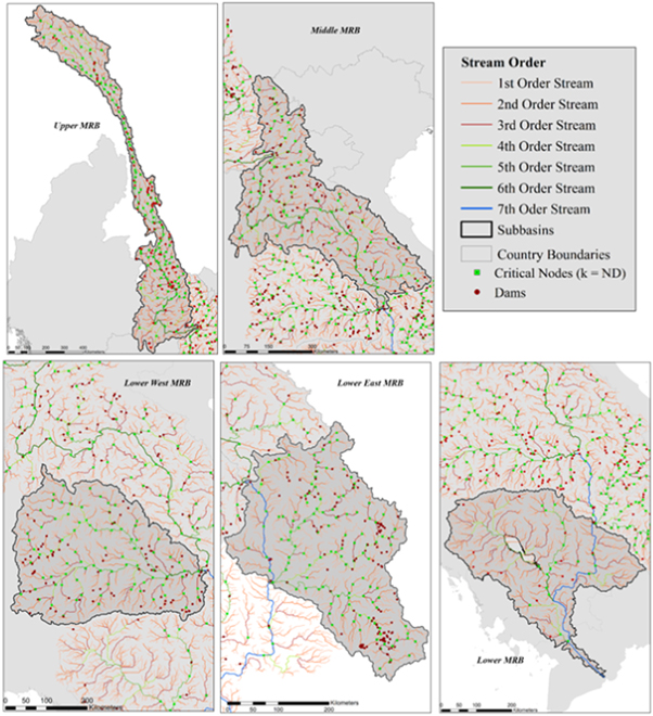
In riverine ecosystems, biological and ecological communities frequently occur in spatially structured environments where connectivity plays a direct role in their functions [21–23]. Consequently, the reduction in the connectivity of a Mekong River Network (MRN) is a direct measure of the integrity of the MRB [24]. In this study, we emphasized on the positions of the dams and their suitability on the entire MRN in order to hold integrity and vulnerability of the MRN as a proxy to understand environmental and ecological integrity of the entire MRB. Therefore, our objective was to identify critical nodes on a suit of the MRN obtained from the digital elevation model (DEM) data, which was sufficiently robust to support ecological processes in this enormous river basin using the recently published critical node identification (CNI) framework [24, 25]. Such studies are expected to enhance our understanding on the suitability of existing/planned dams in the MRN system and their integrity with the ecosystem functioning of the MRB.
2. Study area and data
2.1. Description of study area
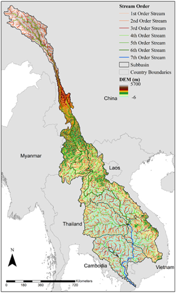
The Mekong River Basin is classified by its unique and complex hydrologic, climatic, and physiographic characteristics. The River originates in China's Tibetan Plateau and then flows through Myanmar, Laos, Thailand, and Cambodia (see figure 1), draining a ∼ 795, 000 km2 basin to the ocean in the Vietnam's Mekong Delta with an annual mean flow of ∼ 15, 000 km3/year [4, 26]. The Mekong River is the basin's primary river, ranking tenth in the world in terms of mean annual flow at its mouth and second next to the Amazon River in terms of aquatic biodiversity and freshwater catch fisheries [3, 27, 28].
Figure 1. Mekong river basin along with river network.
Download figure:
Standard image High-resolution image2.2. Data
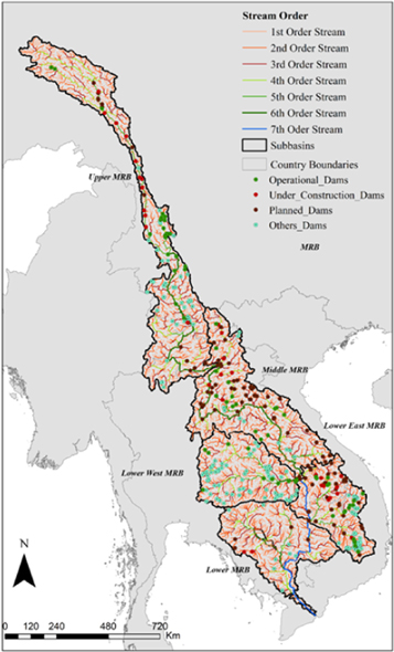
We used geo-referenced dam data from the Consultative Group for International Agricultural Research (CGIAR), which is an open access and contains other attributes of dams as well. The data is publicly available at (https://wle-mekong.cgiar.org/maps/, accessed on 15 March 2021). The digital elevation model (DEM) data was collected from the HydroSHEDS (https://www.hydrosheds.org/, accessed on 15 march 2021) [29]. Classification of dams and their locations on the MRB is shown in Figure 2.
3. Methods
3.1. Mekong River Network (MRN) extraction
In this study, we adopted the DEM data to extract river network for the MRB. DEM displays elevation data in an array of cells and are useful to facilitate hydrologic analysis in Geographic Information Systems (GIS). We computed the river networks from the DEM using an area threshold method [24, 25, 30] by using ArcGIS.
3.2. Critical nodes detection
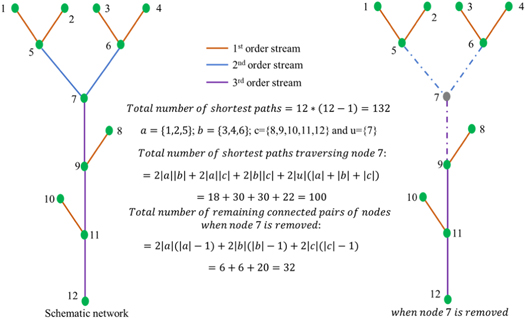
Critical nodes are a subset of nodes that their removal cause the greatest amount of network fragmentation. This can be accomplished by reducing the size of the largest remaining connected components or by minimizing pairwise connectivity, which is the total number of node pairs connected by a path. In figure 3, a schematic example river network is shown to illustrate the concept of pairwise connectivity, where number of the CNs is considered to be equal to 1 (i.e., k = 1) and a, b, and c are the remaining connected components (i.e., fragmentation) due to the removal of node 7. In other words, 7 is a subset of nodes, whose removal cause the greatest amount of network fragmentation or minimum size of the largest remaining connected components (i.e., a, b, and c). In general mathematical formulations to identify CNs on MRN can be written as follows:
In order to identify critical nodes of the MRB, the MRN is represented by using a simple unidirected graph  with a set of nodes N and links E. The links connecting node i ∈ N and j ∈ N are represented by a pair
  . Let
. Let  denote the neighbourhood of node i. In this formulation, we assume that up to k nodes in this graph are deleted as critical nodes, where k is the user defined parameter that can be selected based on the number of internal structure i.e., number of Dams (k = ND) For any node i ∈ N, we define the indicator variable vi
as equation (1) (see details in [24, 25]).

Then, for each pair of nodes i, j ∈ V (i ≠ j), we define the indicator variable uij as equation (2) (see details in [24, 25]).

The objective function, which quantifies the number of connected node pairs in the remaining graph, and the limit on the number of removed nodes can be expressed as  and
and  , respectively. Critical nodes can then be determined via minimizing the objective function using linear integer programming. For more details on method to identify critical nodes see [24, 25, 31–33].
In fact the formulation of these critical nodes is solely based on network connectivity. However, in order to better understand network vulnerability (i.e., the optimal response of a network to an internal structure) and protection (i.e., network defense), this disruption metric can be used in conjunction with other metrics (see details in [24]).
4. Results and discussion
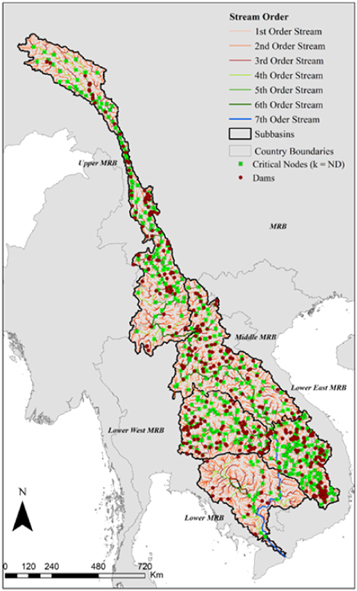
Figure 4 shows the locations of computed critical nodes (i.e., CNs) under the criteria k = ND as detailed in the methods section. For simplicity, the four categories of dams presented in figure 2 are lumped into one category to define the value of k, i.e., k = ND. Computed CNs were superimposed on the extracted MRN for visualization purposes. The channel order of the MRN based on the Horton-Strahler [24, 34] ordering scheme is shown in figure 4 with different colors. Furthermore, red color indicated the dams and green color are indicated the computed CNs. Figure 4 clearly indicates that all the dams are not coincided with the CNs. However, some of them are very close to the locations of CNs.
Figure 2. Classification of dams and their location on MRB. Figure 6 of the appendix depicts the sub-basins wise dams and their location.
Download figure:
Standard image High-resolution imageFigure 3. Schematic example of a river network to illustrate the concepts of 'connectivity' and 'fragmentation. Different colors indicate the order of streams.
Download figure:
Standard image High-resolution imageFigure 4. Dam's location and Critical nodes on MRB. Figure 7 of the appendix depicts the sub-basins wise location of dams and critical nodes.
Download figure:
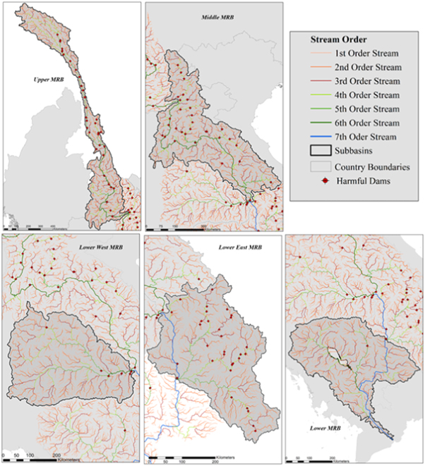
Standard image High-resolution imageOut of all the available dams in the MRB, we identified the harmful dams based on the location of dams and their channel connectivity. For example, the harmful dams for the five sub-basins of the MRB are shown in figure 5 whereas table 1 summarizes the dams' properties. The harmful dams for the five sub-basins are shown in the figure 5 and their details attribute are also included in the table 1.
Figure 5. Identified harmful dams on MRN . Figure 8 of the appendix depicts the harmful dams for five sub-basins of MRN.
Download figure:
Standard image High-resolution imageTable 1. List of dams that are harmful to the mekong river basin's ecological integrity.
| S. no | Location | Rivers | Purpose | Capacity | Size | Height | Status | Completion Year |
|---|---|---|---|---|---|---|---|---|
| 1 | Kham, Tibet, China | Lancang | N/A | 108 | N/A | Planned | N/A | |
| 2 | China | N/A | 10.8 | N/A | Planned | N/A | ||
| 3 | Kham, Tibet, China | Lancang | N/A | 150 | N/A | Under Construction | N/A | |
| 4 | China | N/A | 16.5 | N/A | Under Construction | N/A | ||
| 5 | China | N/A | 6.6 | N/A | Planned | N/A | ||
| 6 | Kham, Tibet, China | Lancang | N/A | 66 | N/A | Planned | N/A | |
| 7 | China | Lancang | Hydropower | 60 | N/A | Operational | N/A | |
| 8 | Kham, Tibet, China | Lancang | N/A | 160 | N/A | Planned | N/A | |
| 9 | China | N/A | 16 | N/A | Planned | N/A | ||
| 10 | Zhag'yab, Tibet, China | Lancang | N/A | 240 | N/A | Under Construction | N/A | |
| 11 | China | N/A | 24 | N/A | Under Construction | N/A | ||
| 12 | China | N/A | 10 | N/A | Planned | N/A | ||
| 13 | Zhag'yab, Tibet, China | Lancang | N/A | 100 | Small | Planned | N/A | |
| 14 | Zogang, Tibet, China | Lancang | N/A | 1000 | N/A | Planned | N/A | |
| 15 | China | N/A | 100 | N/A | Under Construction | N/A | ||
| 16 | China | Lancang | Hydropower | 3000 | Large | 315 | Planned | N/A |
| 17 | China | N/A | 240 | N/A | Under Construction | N/A | ||
| 18 | Markam, Tibet, China | Lancang | N/A | 2400 | N/A | Planned | N/A | |
| 19 | China | Lancang | Hydropower | 2800 | Large | 310 | Planned | N/A |
| 20 | Markam, Tibet, China | Lancang | N/A | 2400 | N/A | Planned | N/A | |
| 21 | China | N/A | 240 | N/A | Planned | N/A | ||
| 22 | China | Lancang | Hydropower | 2200 | Large | 220 | Under Construction | N/A |
| 23 | China | N/A | N/A | Planned | N/A | |||
| 24 | Deqin, Yunnan, China | Lancang | N/A | 2600 | N/A | Planned | N/A | |
| 25 | Deqin, Yunnan, China | Lancang | N/A | 1200 | N/A | Suspended | N/A | |
| 26 | China | N/A | N/A | Cancelled | N/A | |||
| 27 | China | N/A | N/A | Under Construction | N/A | |||
| 28 | China | Lancang | Hydropower | 960 | Large | 136.5 | Under Construction | N/A |
| 29 | China | N/A | N/A | Planned | N/A | |||
| 30 | Weixi Lisu, Yunnan, China | Lancang | N/A | 1250 | N/A | Planned | N/A | |
| 31 | Lanping, Yunnan, China | Lancang | N/A | 1900 | N/A | Under Construction | N/A | |
| 32 | China | N/A | N/A | Under Construction | N/A | |||
| 33 | China | N/A | N/A | Planned | N/A | |||
| 34 | Yunlong, Yunnan, China | Lancang | N/A | 900 | N/A | Under Construction | N/A | |
| 35 | China | N/A | N/A | Under Construction | N/A | |||
| 36 | Yunlong, Yunnan, China | Lancang | N/A | 1400 | N/A | Under Construction | N/A | |
| 37 | China | N/A | N/A | Operational | N/A | |||
| 38 | Yunlong, Yunnan, China | Lancang | N/A | 900 | N/A | Operational | N/A | |
| 39 | China | N/A | N/A | Operational | N/A | |||
| 40 | China | N/A | N/A | Operational | N/A | |||
| 41 | China | N/A | N/A | Operational | N/A | |||
| 42 | China | N/A | N/A | Operational | N/A | |||
| 43 | China | N/A | Small | Operational | N/A | |||
| 44 | China | Lancang | N/A | N/A | N/A | N/A | ||
| 45 | China | N/A | N/A | Operational | N/A | |||
| 46 | Nanjian Yi, Yunnan, China | Lancang | N/A | 4200 | Large | 292 | Operational | N/A |
| 47 | China | Lancang | N/A | N/A | N/A | N/A | ||
| 48 | Jingdong Yizu, Yunnan, China | Lancang | N/A | 1550 | N/A | Operational | N/A | |
| 49 | China | Lancang | N/A | 920 | N/A | Operational | N/A | |
| 50 | Jingdong Yizu, Yunnan, China | Lancang | N/A | 1350 | N/A | Operational | N/A | |
| 51 | China | N/A | N/A | Operational | N/A | |||
| 52 | China | Lancang | Hydropower | 1350 | Large | 110 | Operational | 2003 |
| 53 | Simao District, Yunnan, China | Lancang | N/A | 5850 | N/A | Operational | N/A | |
| 54 | China | N/A | N/A | Operational | N/A | |||
| 55 | Jinghong City, Yunnan, China | Lancang | N/A | 1750 | N/A | Operational | N/A | |
| 56 | China | Lancang | Hydropower | 155 | Large | 60.5 | Planned | 2015 |
| 57 | Jinghong City, Yunnan, China | Lancang | N/A | 600 | N/A | Cancelled | N/A | |
| 58 | Laos | Ou River | Hydropower | 180 | N/A | Under Construction | 2016 | |
| 59 | Laos | Ou River | Hydropower | 240 | N/A | Under Construction | 2016 | |
| 60 | Laos | Ou River | Hydropower | 75 | Large | 77 | Planned | 2014 |
| 61 | Laos | Hydropower | 97.8 | Small | 11 | Planned | 2017 | |
| 62 | Laos | Ou River | Hydropower | 300 | Large | 37.71 | Planned | 2013 |
| 63 | Laos | Hydropower | 134 | Large | 103 | Planned | 2016 | |
| 64 | Laos | Ou River | Hydropower | 180 | Large | 145 | Planned | 2013 |
| 65 | Laos | Nam Khan | Hydropower | 130 | Large | 177 | Under Construction | 2015 |
| 66 | Laos | Nam Khan | Hydropower | 60 | Large | 151 | Under Construction | 2015 |
| 67 | Laos | Hydropower | 147.19 | Large | 53 | Planned | 2016 | |
| 68 | Laos | Tha River | Hydropower | 168 | Large | 64 | Planned | 2013 |
| 69 | Laos | Hydropower | 1230 | Large | 28 | Planned | 2016 | |
| 70 | Laos | Hydropower | 1285 | Large | 48 | Under Construction | 2019 | |
| 71 | Laos | Hydropower | 43.7 | Large | 35 | Planned | 2019 | |
| 72 | Laos | Hydropower | 84.9 | Large | 22 | Planned | 2019 | |
| 73 | Laos | Hydropower | N/A | Planned | N/A | |||
| 74 | Laos | Mekong | N/A | N/A | Planned | expected 2016 | ||
| 75 | Laos | Hydropower | 1079 | Large | 45 | Planned | 2017 | |
| 76 | Laos | Mekong | N/A | 1079 | N/A | Planned | expected 2017 | |
| 77 | Laos | Nam Lik | Hydropower | 100 | Large | 169 | Operational | 2010 |
| 78 | Laos | Ngum | Hydropower | 54 | Large | 75 | Planned | 2018 |
| 79 | Laos | Ngum | Hydropower | 440 | Large | 220 | Planned | 2014 |
| 80 | Laos | Ngum | Hydropower | 615 | Large | 181.5 | Operational | 2010 |
| 81 | Laos | Ngum | Hydropower | 148.69 | Large | 75 | Operational | 1971 |
| 82 | Near Vientiane, Laos | Ngum | N/A | 148.69 | N/A | Operational | 1872 | |
| 83 | Laos | Nam Lik | Hydropower | 60 | Large | 41 | Under Construction | 2016 |
| 84 | Laos | Ngum | Hydropower | 90 | Large | 47 | Planned | 2018 |
| 85 | Laos | Hydropower | 110 | Large | 214 | Planned | 2020 | |
| 86 | Laos | Hydropower | 210 | Large | 17 | Operational | 2012 | |
| 87 | Laos | Tha River | Hydropower | 523 | Large | 65 | Planned | 2014 |
| 88 | Laos | Nam Theun | Hydropower | 1075 | Large | 155 | Operational | 2009 |
| 89 | Thailand | Hydropower | 25.2 | Large | 35.1 | Operational | 1966 | |
| 90 | Thailand | IRR | N/A | Operational | N/A | |||
| 91 | Thailand | Hydropower | N/A | Operational | N/A | |||
| 92 | Thailand | IRR | N/A | Operational | N/A | |||
| 93 | Tonle Sre Pok, Cambodia | Sre Pok River | N/A | 222 | N/A | Under Construction | expected 2018 | |
| 94 | Thailand | Lam Dom Noi | N/A | 36 | N/A | Operational | 1872 | |
| 95 | Thailand | Hydropower | 36 | Large | 42 | Operational | 1971 | |
| 96 | Thailand | Hydropower | 136 | Large | 17 | Operational | 1994 | |
| 97 | Laos | Mekong | Hydropower | 1872 | Large | 27 | Planned | 2017 |
| 98 | Laos | Hydropower | 248 | Large | 200 | Planned | 2016 | |
| 99 | Laos | Hydropower | 63.4 | Large | 46 | Planned | 2022 | |
| 100 | Laos | Hydropower | 107 | Large | 103 | Planned | 2019 | |
| 101 | Laos | Hydropower | 30 | Large | 33 | Planned | 2021 | |
| 102 | Laos | Hydropower | 300 | Large | 169 | Planned | 2014 | |
| 103 | Laos | Hydropower | 144.6 | Large | 25 | Planned | 2012 | |
| 104 | Laos | Hydropower | 91.1 | Large | 22 | Operational | 2012 | |
| 105 | Laos | Hydropower | 390 | Large | 55 | Under Construction | N/A | |
| 106 | Laos | Hydropower | 60.8 | Large | 37.5 | Planned | 2013 | |
| 107 | Laos | Hydropower | 32 | Large | 65 | Operational | 2011 | |
| 108 | Laos | Hydropower | 54 | Small | 12 | Planned | 2021 | |
| 109 | Laos | Hydropower | 250 | Large | 101.5 | Under Construction | 2013 | |
| 110 | Laos | Hydropower | 64 | Large | 69 | Planned | 2018 | |
| 111 | Laos | Hydropower | 100 | Large | 31 | Planned | 2018 | |
| 112 | Laos | Hydropower | 23 | Large | 55 | Under Construction | 2015 | |
| 113 | Laos | Hydropower | 74 | Small | 12 | Under Construction | 2016 | |
| 114 | Vietnam | Hydropower | 49 | Large | 88 | Planned | N/A | |
| 115 | Vietnam | Hydropower | 86 | Large | 83 | Operational | 2009 | |
| 116 | Vietnam | Hydropower | 12 | Small | 7 | Operational | 1990 | |
| 117 | Vietnam | Sre Pok | N/A | 16 | N/A | Operational | 1908 | |
| 118 | Vietnam | Hydropower | 220 | Large | 52.5 | Operational | 2009 | |
| 119 | Cambodia | Hydropower | 143 | Large | 70 | Planned | N/A | |
| 120 | Vietnam | Hydropower | 96 | Large | 35 | Operational | 2007 | |
| 121 | Cambodia | N/A | N/A | Planned | N/A | |||
| 122 | Vietnam | Hydropower | Large | 31.5 | Operational | 2008 | ||
| 123 | Vietnam | Hydropower | 260 | Large | 69 | Operational | 2006 | |
| 124 | Vietnam | Hydropower | 720 | Large | 71 | Operational | 2001 | |
| 125 | Vietnam | Hydropower | 100 | Large | 71 | Operational | 2008 | |
| 126 | Vietnam | Se San | N/A | 100 | N/A | Operational | 1909 | |
| 127 | Vietnam | Hydropower | 360 | Large | 74 | Operational | 2009 | |
| 128 | Cambodia | Hydropower | 480 | Large | 45 | Planned | 2016 | |
| 129 | Cambodia | Hydropower | 35 | Large | 90 | Planned | N/A | |
| 130 | Cambodia | Hydropower | 25 | Large | 90 | Planned | N/A | |
| 131 | Cambodia | Hydropower | 980 | Large | 22 | Planned | N/A | |
| 132 | Laos | Hydropower | N/A | Planned | N/A | |||
| 133 | Cambodia | Hydropower | 23 | Large | 38 | Planned | N/A | |
| 134 | Thailand | N/A | N/A | Operational | N/A | |||
| 135 | Laos | Hydropower | 260 | Large | 151 | Planned | 2015 | |
| 136 | Laos | Hydropower | 16.8 | Large | 72 | Planned | 2015 |
5. Implications towards ecological and biological contexts of MRB
In this study, we analyzed the positions of dams and their suitability on the Mekong River Network (MRN) through identifying CNs on the MRN. The Mekong River provides ideal conditions for large-scale hydropower development and energy transition [35–37]. There are total of 440 dams on the MRB (figure 2), and 136 of the dams are close to the critical nodes, which may pose harm to biodiversity and ecology of the MRB. There have been transboundary impacts from the upper Mekong River dams, but the lower Mekong River dams may exacerbate these effects because they can cause rapid rises and falls in water levels as well as disrupt sediment transport and block fish migration [5]. The dam may also result in irreversible and permanent ecological transformations to the MRB by altering the hydraulic and hydrological flow regime and negatively impacting fisheries and other aquatic resources [38–40]. In addition, the flow alterations caused by planned dams may further affect a wide range of hydrological and ecological systems across the MRB while fulfilling future energy demands [27].
The effect of network topology can also affect the ecosystems's biodiversity of the dendritic river networks [41], although the influence of the dams on the ecological systems of the MRB may differ. The long-term survival of species and the stability of ecosystems are directly impacted by spatial synchrony, which is well-known. [42]. The network topology of the MRB and its unidirectional flow of water, nutrients, and sediments promote asynchronous dynamics among the populations, thus promoting species persistence [42]. The network branching complexity can directly regulate the degree of synchrony among species. It is also anticipated that the central nodes of the network will have higher levels of connectivity and dispersal than the marginal nodes of the network [43–45]. Accordingly, the area where critical nodes identified close to the main stem, which are mostly distributed among the upper MRB (figure 4), tends to have higher degree of synchrony. Overall, the vulnerability of the ecosystems and biodiversity in the MRB is well recognized and our results provide further theoretical support for their protection.
6. Summary and conclusions
On the MRB, critical nodes are a subset of nodes that their deletion result in maximum fragmentation of the MRN. In this study, we identified critical nodes on the Mekong river network using an optimization approach in which the number of dams is a key constraint, in order to gain a better understanding of the ecological integrity of the MRN under potential disruption of dams. Overall, the main findings of this study can be summarized as follows:
- Critical nodes were superimposed on the Mekong River Network, where we have found that several of the computed critical nodes coincide with the locations of dams.
- Harmful dams were identified based on the location of critical nodes and the location of dams considering channel connectivity.
- We showed that the harmful dams associated with their attributes for five sub-basins, that can be useful for understanding, quantifying, and monitoring of dams effect on the MRB in the context of ecological sustainability.
Our findings indicate the possibility of identifying critical nodes based on the number of dams, their impact on the MRB, and their ecological characteristics as a result of human activities. By identifying critical nodes and harmful dams, this study could also provide useful information on the environmental consequences of the constructed or planned dams for the MRB and its riparian communities.
Apart from topological connectivity, it is also important to maintain persistent flow of sediment, water, and other environmental fluxes in order to minimize the fragmentation of ecological and biological connectivity. Our findings imply that the location of continuous monitoring of environmental fluxes, particularly water quality parameters such as total nitrogen, total phosphorus, water temperature, sediment concentration, and other potentially harmful and essential natural constituents, is a possibility. The identified CNs can be used as the most effective locations for monitoring and quantifying these environmental fluxes in order to evaluate the effect of dams on the MRB. Furthermore, continues evaluation of the MRB's hydrological and environmental fluxes can be done by utilizing eco-hydrological models, such as Soil and Water Assessment Tool (SWAT [46]), Hydrological Simulation Program–Fortran (HSPF [47]), others, and calibrating the models with collected hydrological and environmental fluxes at CNs identified by this study.
Acknowledgments
This research was partially funded by the Doctoral Scientific Research Startup Foundation of Xinjiang University grant 620 321 004, and the Natural Science Foundation of Xinjiang Uygur Autonomous Region grant 2022D01C40.
Data availability statement
The data that support the findings of this study are openly available at the following URL/DOI:https://doi.org/https://wle-mekong.cgiar.org/maps/.
Author contributions
Y G and S S planned and conceptualized the research idea, S S developed the methodology and carried out the simulations, T S and S S organized the figures and analyzed the data. O T L contributed to the interpretation of the findings and editing the manuscript. Funding is gathered by Y G Each author contributed to the preparation of the manuscript.
: Appendix
Figure 6. Classification of dams and their location by sub-basin.
Download figure:
Standard image High-resolution imageFigure 7. Sub-basins wise Dam's location and Critical nodes.
Download figure:
Standard image High-resolution imageFigure 8. Identified harmful dams for five sub-basins on MRN.
Download figure:
Standard image High-resolution image