Nothing Special   »   [go: up one dir, main page]

2022

NY1914 : Upstream Warnscale Beck, looking to Fleetwith Pike

taken 2 years ago, 3 km from Buttermere, Cumbria, England
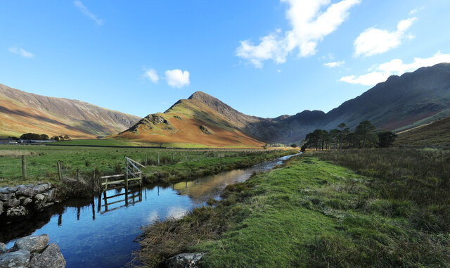
Upstream Warnscale Beck, looking to Fleetwith Pike
Peggy's Bridge carries a bridleway (despite being marked on the map as "footbridge") over Warnscale Beck, flowing from the cirque bounded by Fleetwith Pike (sunlit), Grey Knotts, Brandreth and Haystacks. As the beck crosses the flat marshy area where sediment has filled in the former extent of Buttermere, its sedate waters form reflections of the sunlit uplands beyond. The track leads north to Gatesgarth, a good starting point for a tour of that cirque and (on today's walk) an ascent of Haystacks, a peak I'd previously failed to visit.

Creative Commons Licence [Some Rights Reserved]   © Copyright Andy Waddington and licensed for reuse under this Creative Commons Licence.
Geographical Context: Uplands Sport, Leisure Rivers, Streams, Drainage Moorland Category: Beck Category: Beck other tags: Pike Click a tag, to view other nearby images.
This photo is linked from: Automatic Clusters: · Looking [11] · Peggy's Bridge [7] · Warnscale Beck [4] · Ascent of Haystacks [4] · Bridleway [4] · Starting Point [2] ·
1:50,000 Modern Day Landranger(TM) Map © Crown Copyright
+
+
1:50,000 Modern Day Landranger(TM) Map © Crown Copyright
TIP: Click the map for more Large scale mapping
Grid Square
NY1914, 86 images   (more nearby 🔍)
Photographer
Andy Waddington   (more nearby)
Date Taken
Thursday, 13 October, 2022   (more nearby)
Submitted
Tuesday, 18 October, 2022
Subject Location
OSGB36: geotagged! NY 1902 1475 [10m precision]
WGS84: 54:31.2926N 3:15.1559W
Camera Location
OSGB36: geotagged! NY 1896 1478
View Direction
East-southeast (about 112 degrees)
Clickable map
+
NW N NE
W Go E
SW S SE
Image Type (about): cross grid 
This page has been viewed about 74 times
You are not logged in | login | register