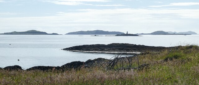
NM7212 : Luing - View to Dubh Sgeir and islands beyond
taken 3 years ago, near to Cullipool, Luing, Argyll And Bute, Scotland

In the foreground the dark southern end of Sgeir Bhuidhe appears to be a promontory but is in fact an off-shore skerry.
The group of islands known as The Slate Islands form an archipelago in the Firth of Lorn to the SSW of Oban.
They get their name from the fact that they were extensively quarried for slate, particularly in the C19th. The populations of these islands were then much higher than they are now, with most of the men involved in quarrying the slate.
There are four principal Slate Islands, Easdale, Seil, Luing and Belnahua. Some also include the islands of Torsa (113 ha (280 acres)) and Shuna (451 ha (1,114 acres)) though neither of these islands had slate commercially extracted. These two small islands lie off the eastern coast of Luing, and while Torsa does have slate formations which were never exploited, Shuna is mostly composed of other rocks. See the end of this article for information on yet more 'claimants' to Slate Island status!
The two smallest islands, Easdale and Belnahua were the most extensively quarried, at least as a percentage of their land area.
Belnahua, the smallest island at just 6ha (15 acres) is no longer inhabited and access to it requires organising a trip with a local boatman. At its most active however as many as 200 people lived on this tiny island.
For information on the main four Slate Islands, please see their own shared descriptions, listed below:
Belnahua: Link
Easdale (Eilean Eisdeal): Link
Seil (Saoil): Link
Luing (Luinn): Link
Various other islands and islets are occasionally included within the Slate Islands. Most of these would more accurately be called 'Islands of the Firth of Lorn' as they are included purely for their geographical location rather than any appreciable quarrying of slate (or any at all in many cases). The two largest islands sometimes referred to in this way are Kerrera (1,214 ha (4.69 miles▓)) just off the coast from Oban and lofty Scarba (1,474 ha (5.69 miles▓) which reaches an altitude of 449m (1,473')) which lies between Luing and Jura.
Some of the smaller islets that are sometimes considered to be Slate Islands are those that cluster to the west of Luing , namely (from roughly south to north)
Lunga (Lorn not Treshnish) (250 ha (1 mile▓)),
Eilean Dubh Mor (50 ha (124 acres)) & Beag (15 ha (37 acres)),
Ormsa, Dubh Sgeir, Fladda and also, off the western coast of Seil the substantial Insh Island (33 ha (82 acres)).
I don't think that the Garvellachs were ever considered as Slate Islands however.
The island of Luing (Gaelic: Luinn) is one of the Slate Islands in the Firth of Lorn, due south of its sister island Seil (Saoil), Luing being the slightly larger island (3,533 acres Cf. 3,284)
It is a verdant island with its own breed of cattle Linkthat roam in the fields.
Its main settlements are Cullipool (its 'capital') on the west coast and Toberonochy on the east. It is reached by a vehicle ferry from Cuan on the southeastern tip of Seil - see summer timetable here Link
The views from near Cullipool across the Sound of Luing to the myriad islets and skerries are excellent.
Luing statistics
Area: 1,430ha (3,533 acres, 5.52 miles▓) [Rank: 40]
Population: 195 [Rank: 32= the same as Coll (Cola)]
Density: 13.63/km▓ (35.33/mile▓)
Highest Point: Cnoc Dhomhnuill at 94m (308')
Chief settlement: Cullipool
Website: Link