Nothing Special   »   [go: up one dir, main page]

2021

TQ1649 : Dorking West Station

taken 4 years ago, near to Dorking, Surrey, England

This is 1 of 12 images, with title Dorking West Station in this square
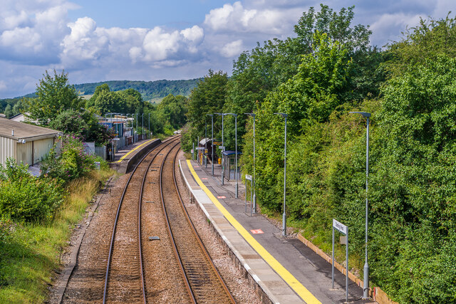
Dorking West Station
Station on the North Downs Line, viewed from the Ranmore Road overbridge. It was originally the only station in Dorking, opened in 1849. The staggered platforms were an original feature. It was renamed Dorking Town station in 1923 by the Southern Railway and Dorking West in 1987 by British Railways. However its inconvenient site, and the increasing importance of what is now Dorking station (previously Dorking North) on the London - Horsham railway and the adjacent Dorking Deepdene station, the next station east along the North Downs Line, led to its decline, with the substantial station building being demolished in 1969. It is now an unstaffed halt, with an off peak service of one train each way every other hour (compared with Dorking Deepdene, which has 2 trains per hour, one of which is a limited stop service).

Creative Commons Licence [Some Rights Reserved]   © Copyright Ian Capper and licensed for reuse under this Creative Commons Licence.
Geographical Context: Suburb, Urban fringe Railways Place: Dorking Building: Vine Court Railway: North Downs Line Station: Dorking West
1:50,000 Modern Day Landranger(TM) Map © Crown Copyright
+
+
1:50,000 Modern Day Landranger(TM) Map © Crown Copyright
TIP: Click the map for more Large scale mapping
Grid Square
TQ1649, 927 images   (more nearby 🔍)
Photographer
Ian Capper   (more nearby)
Date Taken
Tuesday, 3 August, 2021   (more nearby)
Submitted
Wednesday, 22 December, 2021
Subject Location
OSGB36: geotagged! TQ 160 498 [100m precision]
WGS84: 51:14.1835N 0:20.3837W
Camera Location
OSGB36: geotagged! TQ 161 498
View Direction
WEST (about 270 degrees)
Clickable map
+
NW N NE
W Go E
SW S SE
Image Type (about): geograph 
This page has been viewed about 33 times
You are not logged in | login | register