Nothing Special   »   [go: up one dir, main page]

2024

SH4758 : Bythynnod teras / terraced cottages, Dinas

taken 1 year ago, near to Dinas, Gwynedd, Wales
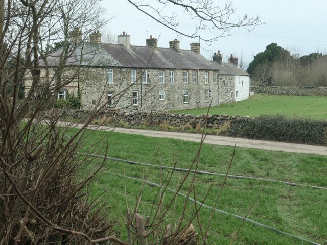
Bythynnod teras / terraced cottages, Dinas
Built before 1888, with no back gardens and no back doors. The paved track in the foreground is the exact route of the Nantlle Tramway. This horse-drawn narrow gauge railway opened in 1828, to bring slate from the Nantlle quarries down to the Slate Quay at Caernarfon. The section from Pant, through Bontnewydd and almost to Penygroes closed in 1867, when it was replaced by a standard gauge railway. The new railway took a straighter line than the older tramway, curving to and from what is now the Welsh Highland Railway and Lon Eifion. It is clearly shown on the large-scale OS maps surveyed in the 1880s.

Creative Commons Licence [Some Rights Reserved]   © Copyright Christine Johnstone and licensed for reuse under this Creative Commons Licence.
Geographical Context: Housing, Dwellings Primary Subject: Cottages other tags: Terrace of Cottages Rear Wall of Cottage Terrace Former Mineral Tramway Line of Former Tramway Nantlle Tramway Click a tag, to view other nearby images.
This photo is linked from: Automatic Clusters: · Route [13] · Bring Slate from the Nantlle Quarries [3] · Paved Track [2] ·
1:50,000 Modern Day Landranger(TM) Map © Crown Copyright
+
+
1:50,000 Modern Day Landranger(TM) Map © Crown Copyright
TIP: Click the map for more Large scale mapping
Grid Square
SH4758, 191 images   (more nearby 🔍)
Photographer
Christine Johnstone   (more nearby)
Date Taken
Saturday, 13 January, 2024   (more nearby)
Submitted
Monday, 22 January, 2024
Subject Location
OSGB36: geotagged! SH 4762 5871 [10m precision]
WGS84: 53:6.2258N 4:16.6561W
Camera Location
OSGB36: geotagged! SH 4768 5873
View Direction
West-southwest (about 247 degrees)
Clickable map
+
NW N NE
W Go E
SW S SE
Image Type (about): geograph 
This page has been viewed about 19 times
You are not logged in | login | register