Nothing Special   »   [go: up one dir, main page]

1974

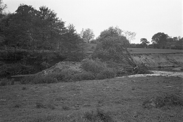
SJ8082 : Oxbow formation, River Bollin (2)

taken 51 years ago, near to Morley Green, Cheshire East, England

Oxbow formation, River Bollin (2)
There are several oxbow lakes along the former course of the River Bollin. This is the second of two oxbows here known to have formed over the winter of 1973-74 SJ8082 : Oxbow formation, River Bollin (1). The levee of the second oxbow, to the right of the tree is an expanse of fine alluvial sands, but the oxbow was still connected to the river (to the right) by a very small channel.

Creative Commons Licence [Some Rights Reserved]   © Copyright Richard Sutcliffe and licensed for reuse under this Creative Commons Licence.
Geographical Context: Geological interest Rivers, Streams, Drainage Woodland, Forest River: River Bollin Primary Subject: River other tags: Scanned Negative Oxbow Lake Formation Click a tag, to view other nearby images.
This photo is linked from: Automatic Clusters: · Oxbow Formation [3] Other Photos: · Oxbow formation, River Bollin (1) · Oxbow formation, River Bollin (3) ·
1:50,000 Modern Day Landranger(TM) Map © Crown Copyright
+
+
1:50,000 Modern Day Landranger(TM) Map © Crown Copyright
TIP: Click the map for more Large scale mapping
Grid Square
SJ8082, 54 images   (more nearby 🔍)
Photographer
Richard Sutcliffe   (more nearby)
Date Taken
Wednesday, 29 May, 1974   (more nearby)
Submitted
Tuesday, 4 April, 2023
Subject Location
OSGB36: geotagged! SJ 8097 8261 [10m precision]
WGS84: 53:20.4027N 2:17.2361W
Camera Location
OSGB36: geotagged! SJ 8100 8259
View Direction
West-northwest (about 292 degrees)
Clickable map
+
NW N NE
W Go E
SW S SE
Image Type (about): cross grid 
This page has been viewed about 36 times
You are not logged in | login | register