Nothing Special   »   [go: up one dir, main page]

2019

NZ2547 : The main street in Nettlesworth

taken 5 years ago, near to Kimblesworth, County Durham, England
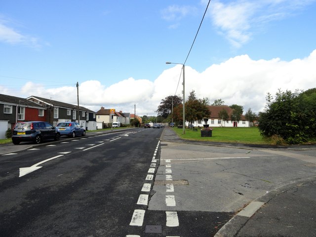
The main street in Nettlesworth
This is looking west along Park View, part of the B6312 which runs through the village from Sacriston, to the main A167 a short distance west of here. Most of the village housing is of fairly recent origins, as shown here. The village was created as miners houses in the mid 19th century, but there was an earlier one dating back to medieval times. However, it wasn't on this site, but a couple of kilometres to the west, near present day Sacriston.

Creative Commons Licence [Some Rights Reserved]   © Copyright Robert Graham and licensed for reuse under this Creative Commons Licence.
Geographical Context: Village, Rural settlement Housing, Dwellings Roads, Road transport Primary Subject: Street other tags: Village Main Street Village Main Road Housing Estate Ex-Mining Village Click a tag, to view other nearby images.
This photo is linked from: Automatic Clusters: · Village of Nettlesworth [7] · B6312 [5] · Park View [4] · Date [2] ·
1:50,000 Modern Day Landranger(TM) Map © Crown Copyright
+
+
1:50,000 Modern Day Landranger(TM) Map © Crown Copyright
TIP: Click the map for more Large scale mapping
Grid Square
NZ2547, 19 images   (more nearby 🔍)
Photographer
Robert Graham   (more nearby)
Date Taken
Monday, 23 September, 2019   (more nearby)
Submitted
Sunday, 20 October, 2019
Subject Location
OSGB36: geotagged! NZ 2573 4772 [10m precision]
WGS84: 54:49.4200N 1:36.0637W
Camera Location
OSGB36: geotagged! NZ 2578 4769
View Direction
West-northwest (about 292 degrees)
Clickable map
+
NW N NE
W Go E
SW S SE
Image Type (about): geograph 
This page has been viewed about 57 times
You are not logged in login | register