Nothing Special   »   [go: up one dir, main page]

2019

SO1500 : Welsh/English plaque for The Man Who Never Was, Aberbargoed War Memorial

taken 6 years ago, near to Aberbargoed, Caerphilly/Caerffili, Wales
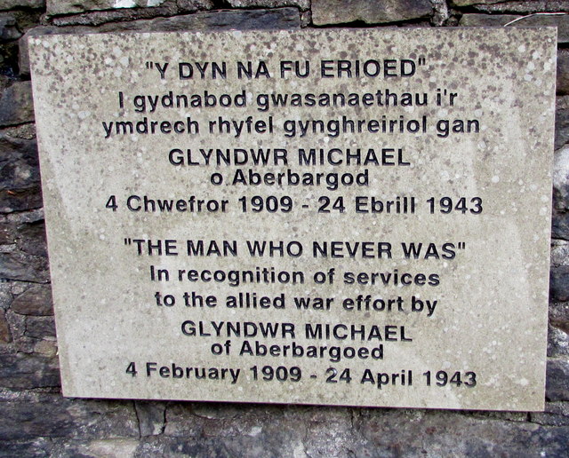
Welsh/English plaque for The Man Who Never Was, Aberbargoed War Memorial
Located here. Link Glyndwr Michael (1909-1943) was a native of Aberbargoed. After his death, he was The Man Who Never Was, a strategy which played a major part in the course of World War II. His corpse, disguised as a Royal Marines officer, was put into the Mediterranean with a briefcase containing documents which convinced the Germans that the Allies planned to attack Greece in the summer of 1943. The real target was Italy.
War Memorials

War memorials were mainly constructed after WWI to commemorate the troops who gave their lives in the war. Many were then updated after WWII. Some war memorials date back to the Boer War. Almost every town and village in Britain has a War Memorial. They take many forms, the commonest being an obelisk, a cross or statue of a soldier. Some commemorate the inhabitants of a place, some are for schools and others are for companies or Military groupings.
Many memorials are grade II listed, 61 are II* listed, LinkExternal link*_listed_war_memorials_in_England
& 12 are Grade I listed. LinkExternal link
A search for memorials can be carried out at LinkExternal link


Creative Commons Licence [Some Rights Reserved]   © Copyright Jaggery and licensed for reuse under this Creative Commons Licence.
Geographical Context: Historic sites and artefacts Village, Rural settlement other tags: War Memorial Plaque Click a tag, to view other nearby images.
This photo is linked from: Automatic Clusters: · Plaque [6] Other Photos: · Green benches, Aberbargoed War Memorial ·
1:50,000 Modern Day Landranger(TM) Map © Crown Copyright
+
1:50,000 Modern Day Landranger(TM) Map © Crown Copyright
TIP: Click the map for more Large scale mapping
Grid Square
SO1500, 233 images   (more nearby 🔍)
Photographer
Jaggery   (more nearby)
Date Taken
Wednesday, 5 June, 2019   (more nearby)
Submitted
Friday, 6 September, 2019
Subject Location
OSGB36: geotagged! SO 1553 0008 [10m precision]
WGS84: 51:41.5855N 3:13.4088W
Camera Location
OSGB36: geotagged! SO 1553 0008
View Direction
East-southeast (about 112 degrees)
Clickable map
+
NW N NE
W Go E
SW S SE
Image Type (about): close look 
This page has been viewed about 348 times
You are not logged in | login | register