Nothing Special   »   [go: up one dir, main page]

2021

TG0536 : Thornage village sign

taken 4 years ago, near to Thornage, Norfolk, England

This is 1 of 2 images, with title Thornage village sign in this square
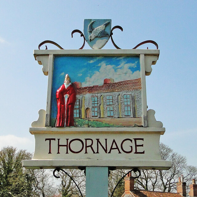
Thornage village sign
This side of the sign depicts bishop James Goldwell and Thornage Hall where he lived and had a deer park. It makes you wonder where he got all the money to pay for it. The other side of the sign Link depicts the 19th century brass and iron foundry founded (no pun intended) by John Mann. The falcon which is on the shield atop the sign represents, falconry which was something else the bishop enjoyed at the expense of the common man. Link
Village Signs of East Anglia

Village signs are typically placed along the principal road or in a prominent location such as a village green or close by the church. The design often depicts a particularly feature of the village or a scene from its history, heritage, or culture. They are typically made of wood or metal or a combination of both, the designs are often made by the local community.
Although they do appear in villages and towns all over the country they are more prominent in East Anglia than elsewhere in the country.


Creative Commons Licence [Some Rights Reserved]   © Copyright Adrian S Pye and licensed for reuse under this Creative Commons Licence.
Geographical Context: Village, Rural settlement Primary Subject: Village Sign County: Norfolk Place: Thornage other tags: Norfolk Village Sign Village + Sign Village Sign Detail Village Sign Norfolk Village Signs Thornage - Norfolk Thornage Click a tag, to view other nearby images.
This photo is linked from: Articles: · Village signs of Norfolk Automatic Clusters: · Thornage Village Sign [9] · Thornage Hall [6] · Shield Atop the Sign Represents [3] Other Photos: · New village sign at Thornage Title Clusters: · Thornage village sign [2] ·
1:50,000 Modern Day Landranger(TM) Map © Crown Copyright
+
+
1:50,000 Modern Day Landranger(TM) Map © Crown Copyright
TIP: Click the map for more Large scale mapping
Grid Square
TG0536, 33 images   (more nearby 🔍)
Photographer
Adrian S Pye   (more nearby)
Date Taken
Tuesday, 20 April, 2021   (more nearby)
Submitted
Friday, 23 April, 2021
Subject Location
OSGB36: geotagged! TG 0503 3633 [10m precision]
WGS84: 52:53.1195N 1:2.7542E
Camera Location
OSGB36: geotagged! TG 0503 3634
View Direction
Southwest (about 225 degrees)
Clickable map
+
NW N NE
W Go E
SW S SE
Image Type (about): close look 
This page has been viewed about 61 times
You are not logged in login | register