Nothing Special   »   [go: up one dir, main page]

2017

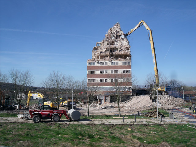
SJ9894 : Hattersley multi-storey flats demolition

taken 8 years ago, near to Broadbottom, Tameside, England

Hattersley multi-storey flats demolition
This tower block is the last building to be demolished in the area that was Hattersley Precinct. When completed in the late 1960s/early 1970s the Four in Hand public house stood to the right of the tower, the red machine stands on the walkway that originally had shops on both sides and the ends, about 25 shops in total selling all sorts of goods even a record shop. Most of the shops were demolished 25/30 years ago the rest following more recently. Close up Link

Creative Commons Licence [Some Rights Reserved]   © Copyright Stephen Burton and licensed for reuse under this Creative Commons Licence.
Geographical Context: Suburb, Urban fringe Derelict, Disused Season: Spring Place: Hattersley Primary Subject: Demolition Site other tags: Demolition Click a tag, to view other nearby images.
1:50,000 Modern Day Landranger(TM) Map © Crown Copyright
+
+
1:50,000 Modern Day Landranger(TM) Map © Crown Copyright
TIP: Click the map for more Large scale mapping
Grid Square
SJ9894, 135 images   (more nearby 🔍)
Photographer
Stephen Burton   (more nearby)
Date Taken
Friday, 24 March, 2017   (more nearby)
Submitted
Saturday, 25 March, 2017
Subject Location
OSGB36: geotagged! SJ 9827 9469 [10m precision]
WGS84: 53:26.9382N 2:1.6509W
Camera Location
OSGB36: geotagged! SJ 9834 9469
View Direction
WEST (about 270 degrees)
Clickable map
+
NW N NE
W Go E
SW S SE
Image Type (about): geograph 
This page has been viewed about 171 times
You are not logged in login | register