Nothing Special   »   [go: up one dir, main page]

2014

NG2157 : Ruined Houses On Main Street Iosaigh

taken 11 years ago, 4 km SW of Halistra, Isle of Skye, Scotland
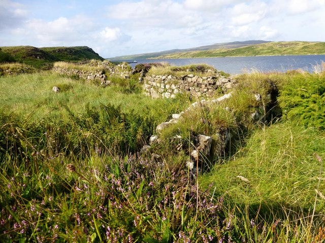
Ruined Houses On Main Street Iosaigh
The island was home to a small fishing community in around the 1830s, which included a general store and fishing station, and by 1841 supported 15 families "in considerable comfort". However, like many other small islands, the population of around ninety were removed during the Highland clearances to make way for sheep. The remains of the 18 or more cottages can be clearly seen from the Waternish peninsula, which overlooks the three islands. There were no evidence that sheep graze this island any more.
The island was briefly owned by the singer Donovan in the 1960s.

Creative Commons Licence [Some Rights Reserved]   © Copyright Rude Health and licensed for reuse under this Creative Commons Licence.
Geographical Context: Coastal Historic sites and artefacts Housing, Dwellings Islands Derelict, Disused Primary Subject: Ruin Near: Isle of Skye Island: Iosaigh other tags: Iosaigh Click a tag, to view other nearby images.
1:50,000 Modern Day Landranger(TM) Map © Crown Copyright
+
+
1:50,000 Modern Day Landranger(TM) Map © Crown Copyright
TIP: Click the map for more Large scale mapping
Grid Square
NG2157, 10 images   (more nearby 🔍)
Photographer
Rude Health   (more nearby)
Date Taken
Saturday, 9 August, 2014   (more nearby)
Submitted
Friday, 15 August, 2014
Subject Location
OSGB36: geotagged! NG 2194 5712 [10m precision]
WGS84: 57:31.1132N 6:38.7425W
Camera Location
OSGB36: geotagged! NG 2194 5710
View Direction
North-northeast (about 22 degrees)
Clickable map
+
NW N NE
W Go E
SW S SE
Image classification(about): Geograph (Third Visitor for NG2157)
This page has been viewed about 62 times
You are not logged in | login | register