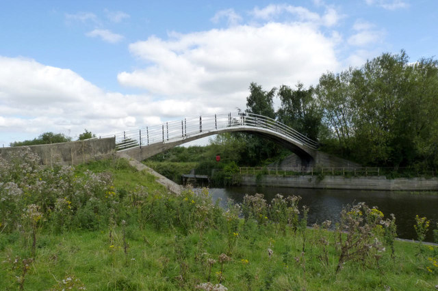
SK8055 : Fiddler's Elbow Bridge - 3
taken 12 years ago, near to Newark-on-Trent, Nottinghamshire, England

Most people probably wouldn't give this bridge more than a cursory glance, but it is well worth a critical look.
It was built in 1915 by the firm of Mouchel and Partners, which had been founded in the UK to develop the techniques of reinforced concrete construction pioneered by the Frenchman Francois Hennebique. As such it is a very early example of the technique, in recognition of which it has been awarded Grade II* Listed status. The fine lines of the arch are remarkable; with a span of 90 feet, the depth of the arch over about 2/3rds of its length is a mere 8 inches. The quality of the workmanship is evidenced by the fact that the concrete shows no signs of spalling or exposure of the reinforcement. The arch is said to have been cast as a single pour, which would certainly have been an achievement for those times, but probably contributes to its current good condition.
Although the bridge now forms part of the Trent Valley Way long distance footpath, it was not built as a footbridge. It was in fact built by the Trent Navigation Company as a roving or turnover bridge to allow the navigation towpath to change from one side of the river to the other, specifically without the need to unhitch the horse's towrope. As such, it is believed to be the only roving bridge on a wide waterway (over 14ft beam). It was a replacement for an earlier bridge.
Listed buildings and structures are officially designated as being of special architectural, historical or cultural significance. There are over half a million listed structures in the United Kingdom, covered by around 375,000 listings.
Listed status is more commonly associated with buildings or groups of buildings, however it can cover many other structures, including bridges, headstones, steps, ponds, monuments, walls, phone boxes, wrecks, parks, and heritage sites, and in more recent times a road crossing (Abbey Road) and graffiti art (Banksy 'Spy-booth') have been included.
In England and Wales there are three main listing designations;
Grade I (2.5%) - exceptional interest, sometimes considered to be internationally important.
Grade II* (5.5%) - particularly important buildings of more than special interest.
Grade II (92%) - nationally important and of special interest.
There are also locally listed structures (at the discretion of local authorities) using A, B and C designations.
In Scotland three classifications are also used but the criteria are different. There are around 47,500 Listed buildings.
Category A (8%)- generally equivalent to Grade I and II* in England and Wales
Category B (51%)- this appears generally to cover the ground of Grade II, recognising national importance.
Category C (41%)- buildings of local importance, probably with some overlap with English Grade II.
In Northern Ireland the criteria are similar to Scotland, but the classifications are:
Grade A (2.3%)
Grade B+ (4.7%)
Grade B (93%)
Read more at Wikipedia Link
The River Trent is the third longest river in England (185 miles). It rises on Biddolph Moor, Staffordshire, then follows a generally north east to northerly path to join the River Ouse at Trent Falls. The Ouse & Trent combined form the Humber Estuary.
It is a very important river, economically having a number of Power Stations and industrial sites along its banks. It is navigable as far as Burton-On-Trent.
Wikipedia: Link