Nothing Special   »   [go: up one dir, main page]

2012

TL9604 : Lych Gate at St Lawrence

taken 13 years ago, near to St Lawrence, Essex, England
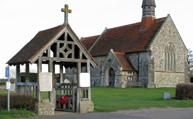
Lych Gate at St Lawrence
The church dates from 1877. For more info on the church see LinkExternal link (Archive LinkExternal link ) which includes this interesting snippet: Three generations of the Wedgwood Benn family lie beneath the floor of the chancel including Lord Stansgate, father of the politician Anthony Wedgwood Benn.
Dengie Peninsula

The Dengie (pronounced with a soft G) Peninsula is an area of South Essex, bounded by the River Blackwater to the north, the River Crouch to the south and the North Sea to the east. The western Boundary of the old "Dengie Hundred" ran from (and included) North Fambridge to Woodham Walter: The nearby town of Maldon was not part of the Dengie Hundred as it was a borough in its own right. See LinkExternal link for a map of the Essex Hundreds.

The area has a relatively low population density, with large areas of farm and marsh land. The largest towns are Burnham on Crouch with a population of c. 7,500 and Southminster with a population of c. 3,800.

Useful links:
Dengie 100 LinkExternal link
Essex-family-history LinkExternal link
wikipedia LinkExternal link


Creative Commons Licence [Some Rights Reserved]   © Copyright Roger Jones and licensed for reuse under this Creative Commons Licence.
Geographical Context: Village, Rural settlement Religious sites Burial ground, Crematorium County: Essex Place: St. Lawrence Dengie Peninsula other tags: Lych Gate C. of E. Parish Church Church Click a tag, to view other nearby images.
This photo is linked from: Automatic Clusters: · St Lawrence [10] · Church [5] ·
1:50,000 Modern Day Landranger(TM) Map © Crown Copyright
+
+
1:50,000 Modern Day Landranger(TM) Map © Crown Copyright
TIP: Click the map for more Large scale mapping
Grid Square
TL9604, 19 images   (more nearby 🔍)
Photographer
Roger Jones   (more nearby)
Date Taken
Sunday, 26 February, 2012   (more nearby)
Submitted
Monday, 27 February, 2012
Subject Location
OSGB36: geotagged! TL 96669 04352 [1m precision]
WGS84: 51:42.2060N 0:50.6882E
Camera Location
OSGB36: geotagged! TL 96654 04359
View Direction
East-southeast (about 112 degrees)
Clickable map
+
NW N NE
W Go E
SW S SE
Image classification(about): Geograph (Fourth Visitor for TL9604)
This page has been viewed about 95 times
You are not logged in | login | register