| Industry | Satellite communication |
|---|---|
| Founded | December 15, 1975 |
| Headquarters | McLean, Virginia, US |
| Owner | IBM, Aetna and COMSAT |
Satellite Business Systems (SBS) was a company founded by IBM, Aetna, COMSAT (and later wholly purchased by IBM and then subsequently sold to MCI), that provided private professional satellite communications through its SBS fleet of FSS geosynchronous satellites, and was the first company to do so.
SBS was founded on December 15, 1975 by the aforementioned companies with the goal of providing a digital satellite communications network for business and other professional clients.
YouTube Encyclopedic
-
1/3Views:5 5205441 279
-
CASA Safety Video - Global Navigation Satellite Systems
-
COMSAT INTELSAT I SATELLITE PROGRAM 1965 ASSEMBLY & LAUNCH 26824
-
The Implications of the Growing Small Satellite Market for Launch and Key Applications
Transcription
Global Navigation Satellite Systems, or GNSS, provide air navigation around the world, from highly integrated systems in airlines to handheld receivers in ultralights. Most people associate GNSS with GPS, the US government's satellite constellation. But things are changing. Soon, the European Union's Galileo constellation will come online. The good news is that the two systems are going to work together, making it even more reliable. There's also a third system, GLONASS, run by the Russians. In this program, we'll look at how GNSS works and what we've learned over the years about human factors, VFR and IFR operations, and how the next generation of GNSS receivers will improve IFR navigation. But let's start with the rocket science. There are three elements to a GNSS system. First, there are the satellites - a minimum of 24 in the case of GPS - in six orbital planes about 11,000 miles above the earth, and each one of them is transmitting GPS signals. Second, there's the GPS receiver giving the pilot positioning, velocity and precise timing information. The receiver compares the ephemeris data transmitted from the satellites with its own almanac information. Finally, there's ground-based control, a network of monitoring stations that checks the accuracy of the satellite positions and their atomic clocks. The GNSS works out a navigation solution for an aircraft from the differences in the time of flight of the radio waves from the GPS satellites to the receiver. And it takes four satellites to tell you where you are. However, the system does have errors. Solar radiation and the gravitational pull of the earth and moon can cause wobbles in the satellites' orbits. The satellites' atomic clock can go haywire. And the ionosphere, a layer of... (CRACKLING) ..charged particles about 200km from the earth's surface, can slow the radio signals down, skewing the position and time information. And there's selective availability, the unit's built-in paranoia - a deliberately introduced error to stop hostile forces using the system against the United States. It's now switched off, but the old receivers don't know that and factor the error in. All of these errors tend to amplify or cancel each other out depending on the geometry of the satellites, but they limit GNSS accuracy to about 15 metres. There's a big difference between aviation and non-aviation receivers. Aviation receivers are certified according to a TSO, or technical standard order, and fitted according to a CASA advisory circular. Uncertified units have no way of detecting errors. Unbelievably, they can be out by more than 500 nautical miles, and they don't meet any of the requirements for IFR navigation. IFR requires a RAIM-capable receiver - either a TSO C-129 or C-145a or 146a. And what's RAIM? It's: And it's how the system maintains integrity by warning you there's a failure in the navigation system. RAIM in C-129 receivers monitors and compares data from five or four satellites and the aircraft's pressure altitude equipment. This is known as fault detection. Sadly, if it detects a faulty satellite, it can't knock it out of the equation, and the receiver becomes as helpful as a house brick, so you're forced to navigate by other means. The new TSO C-145a and 146a receivers are far better, as they have fault detection and exclusion, or FDE. This means they can not only detect a faulty satellite, but eliminate it from the calculations. And they're more like a flight management system with more user-friendly interfaces and improved computing. They don't factor in selective availability and they keep on working at times when the old units tell you the system is down. During flight planning, it's important to get a RAIM prediction NOTAM from Airservices. And they've expanded their service to include the new and old receivers. The prediction precisely forecasts RAIM holes or outages - times when there are too few satellites in the right place to give you service. For example, if you plan to fly to Canberra and do a non-precision approach, and the RAIM prediction service forecasts an outage between 10:00am and 10:20am, you can plan around these times to conduct your approach. But if you blast off thinking the onboard receiver will give you the same prediction, you're wrong. Your receiver doesn't know about the predicted outage and will only find it when you're nearing Canberra, or worse - when you're halfway through the approach. Remember, there's a big difference between an outage and a RAIM warning. A warning is when RAIM has detected a satellite fault and an outage is when there are too few satellites for GNSS navigation. Pilots have taken to GNSS like teenagers to mobile phones, and it's used in 85% of Australian registered aircraft. In IFR operations, you must be qualified in GNSS before you can use it. You have to do ground training based on a syllabus set by CASA at an approved training and checking organisation or an instrument school. It's vital you know what type of receiver you're using, as they're all different. For instance, not all C-129 receivers meet the requirements for non-precision approaches and they can't take advantage of advanced GNSS capabilities. Check operating manuals, know your equipment and know how to use it. Be well aware there are currency requirements if you want to do a GNSS RNAV approach. Night VFR RNAV pilots must hold the appropriate GNSS qualifications and only use aviation-approved TSO C-129 or TSO C-145a or 146a receivers. For VFR, there are no minimum requirements but pilots are encouraged to become familiar with the equipment and carry operating manuals close at hand. But VFR charts should remain the primary reference for navigation. GNSS works on the GIRO - garbage in, rubbish out - principle. So take care with data entry. The interfaces in the new receivers are more user friendly, but training and familiarity are still critical. Button pushing can increase workload, especially if you're trying to learn in flight. It can distract you from other tasks and compromise your ability to make decisions. It's a good idea to get around the technology on the ground, and most GPS suppliers have simulators you can download from their websites. Know the receiver's modes of operations and warnings, especially messages and enunciation it gives en route and during a non-precision approach. Databases must be current and provided by an approved supplier. Manually entered data should be cross-checked for accuracy by two flight crew members, and when operating alone, verify against current maps and charts. Do not attempt to design your own approach. Approach designs are created by experts and there are many levels of validation before approval. Never, ever deviate from a designed approach. Check outputs are sensible and don't fly below published minimum altitudes while in IMC. Pilots have crashed using the wrong procedures. And remember, non-aviation based receivers, including handheld units, can have huge errors. And don't forget how to navigate the old-fashioned way. GNSS junkies often lose critical aviation skills through lack of use. So, what's next? Well, there's good news if you have an old C-129 receiver as some of the manufacturers have promised to upgrade to a TSO C-146a standard soon. Not too far away are vertical guided approaches, or APVs, and the new C-146a receivers are already APV capable. Furthermore, satellite navigation is about to get even better with new augmentation technology. Augmentation corrects the errors in the GPS system using a range of technologies. SBAS, or satellite-based augmentation systems, use dedicated high-orbit geostationary satellites to get ranging, integrity and correction information from a GNSS ground monitoring network. SBAS satellites transmit the data to the aircraft. It promises approaches with vertical guidance. And Australia could get SBAS services from the Japanese MTSAT, a geostationary satellite constellation, and the US WAAS systems. All of the new TSO C-146a receivers are WAAS capable, but Australia doesn't have the ground infrastructure to support WAAS. GBAS, or ground-based augmentation systems, deploy a ground station at the airport to monitor GPS satellites and transmit corrections, integrity parameters and approach data through a VHF uplink on board the aircraft. Then there's ADSB, or automatic dependent surveillance broadcast, a high-performance surveillance system likely to replace radar and being rolled out around Australia. More and more technology to tell you and ATC where you are and where you're going. So let's have a recap. Remember, aviation GNSS receivers meet strict technical standards far above non-aviation units. Know your receiver and its capabilities. Always get your RAIM predictions from Airservices. Thoroughly cross-check manually entered data. Never deviate from designed approaches. And for VFR, maps and charts are your primary means of navigation. So there you have it. Go find yourself!
History
In late 1970, MCI Communications created a subsidiary company named MCI Satellite, Inc. The idea was that satellites could provide 'long distance' service from anywhere to anywhere without having to build thousands of miles of terrestrial network facilities. In early 1971, MCI and Lockheed Missiles and Space Company created a joint venture named MCI Lockheed Satellite Corp. which was the first company to request FCC authorization as a Specialized Common Carrier using satellite based communications. A year later, MCI and Lockheed sought an additional source of funding and Comsat Corp. entered the venture which was renamed CML Satellite Corp. In need of cash, MCI sold its share of the venture to IBM Corporation in 1974 (Lockheed also subsequently sold its share to IBM).
IBM owned one third of the company by 1975.[1] It and Comsat brought in Aetna Insurance Company as a third partner and renamed the company Satellite Business Systems (SBS).
Marketing
The original concept was for a large corporation to install SBS earth stations at each of its major sites. This strategy limited SBS' addressable market to corporations with enough concentrated voice and data traffic to justify the installation of multiple earth stations. Earth stations were generally not shared by SBS customers.
Although the SBS technology provided switched digital, leased digital, switched analog, and leased analog connections between a customer's earth stations, most customers used it mainly for intra-corporate voice calls. Data communications protocols of the period were not efficient over satellite links.
One SBS customer, ISACOMM, extended the business model to smaller corporate customers and provided offnet connectivity as well.
The high initial costs of deploying earth stations, along with the rapid success and expansion of terrestrial competitors like MCI and Sprint, prevented SBS from attaining its commercial targets. Excess transponders on SBS satellites were leased to other companies, and SBS adopted some of ISACOMM's marketing tactics and even pursued the consumer long-distance market on a limited basis.
Technology
SBS' fleet of satellites were the first in orbit to offer transponders in the Ku band, meaning that smaller, less expensive dishes and equipment could be used to receive and transmit to the satellites, making SBS' satellite system attractive for business customers. This was opposed to then-current satellites using the C band of RF spectrum, requiring a larger (and more costly) dish 8 feet (and up) in size. However, Ku signals suffered more from rain fade.
The SBS earth station was designed by IBM. It consisted of a highly modified IBM 1800 and a TDMA modem. All earth stations were managed from the SBS central network operations facility located in McLean, VA, which was also the headquarters location for the corporation.
Historical Note
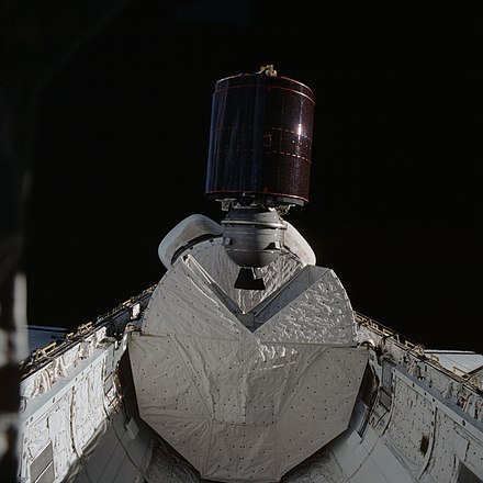
The first use of the NASA Shuttle for commercial purposes was the deployment of the SBS 3 satellite in November, 1982 from STS-5. SBS engineers designed the cradle that sat in the cargo bay of the shuttle and spun up to 50 RPM, then ejected the spinning satellite with the use of explosive bolts.
SBS satellites in orbit
Through its existence as a company, SBS had six satellites in orbit:
| Satellite | Launch (UTC) | Rocket | Launch Site | Fate | Out of Service | Remarks | COSPAR ID |
|---|---|---|---|---|---|---|---|
| SBS 1 | 1980-11-15 22:49 |
Delta 3914 | Canaveral LC-17A | Retired | November 1990 | 1980-091A | |
| SBS 2 | 1981-09-24 23:09 |
Delta 3910 | Canaveral LC-17A | Retired | September 1996 | 1981-096A | |
| SBS 3 | 1982-11-11 12:19 |
Space Shuttle Columbia | Kennedy LC-39A | Retired | June 1995 | First commercial satellite launched by Space Shuttle | 1982-110B |
| SBS 4 | 1984-08-31 12:41 |
Space Shuttle Discovery | Kennedy LC-39A | Retired | September 2005 | 1984-093B | |
| SBS 5 | 1988-09-08 23:00 |
Ariane 3 | Kourou ELA-2 | Retired | March 2000 | 1988-081B | |
| SBS 6 | 1990-10-12 22:58 |
Ariane 4 | Kourou ELA-2 | Retired | April 2009 | 1990-091A | |
SBS 1-5 were built by Hughes using the HS-376 platform. SBS-6 used the HS-393 platform.
SBS 1-6 are no longer in service and have been placed in graveyard orbits. SBS-6 was the last SBS satellite in operation at 74 degrees west longitude. It was decommissioned in July 2007 and replaced by Intelsat Galaxy 17.
The end of SBS
In July 1984, Comsat left SBS, and exactly a year later, Satellite Business Systems was sold to MCI. MCI migrated the voice and data traffic of most SBS customers to its terrestrial network. During the sale of SBS to MCI, four satellites (SBS 1-4) were then in orbit.
In 1987, SBS' fleet was sold off. SBS 1 and 2 were sold to Comsat, SBS 3 remained with MCI, and SBS 4 was sold to IBM's Satellite Transponder Leasing Corporation (STLC) together with the SBS 5 and 6 satellites, which were then still on the ground.
In April 1990, Hughes Communications Inc (HCI), a subsidiary of Hughes Aircraft (who built the satellites) bought STLC from IBM. Sometime later (possibly around 1992) SBS 3 was sold to Comsat. Comsat was later bought by Lockheed Martin.
Due to the divestiture of its fleet (to MCI & HCI, and to Comsat and IBM as well, the former founders of SBS), SBS no longer exists as an entity, with the last satellite left of its fleet, SBS 6, being decommissioned in July 2007 and last being owned by Intelsat.
References
- ^ Greenwald, John (1983-07-11). "The Colossus That Works". TIME. Archived from the original on 2008-05-14. Retrieved 2019-05-18.
External links
| International | |
|---|---|
| National | |