Cuzamá | |
|---|---|
 Principal Church of Cuzamá, Yucatán | |
 Region 3 Centro #015 | |
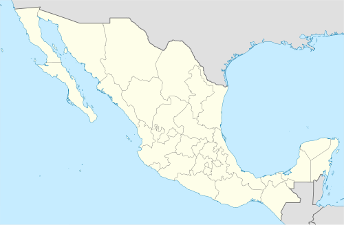 Cuzamá Location of the Municipality in Mexico | |
| Coordinates: 20°44′00″N 89°18′00″W / 20.73333°N 89.30000°W | |
| Country | |
| State | |
| Mexico Ind. | 1821 |
| Yucatán Est. | 1824 |
| Municipality Founded | 1925 |
| Government | |
| • Type | |
| • Municipal President | Wilbert Orlando Soberanis Villanueva[2] |
| Area | |
| • Total | 150.73 km2 (58.20 sq mi) |
| [2] | |
| Elevation | 10 m (30 ft) |
| Population (2010[3]) | |
| • Total | 4,966 |
| • Density | 33/km2 (85/sq mi) |
| Time zone | UTC-6 (Central Standard Time) |
| • Summer (DST) | UTC-5 (Central Daylight Time) |
| INEGI Code | 015 |
| Major Airport | Merida (Manuel Crescencio Rejón) International Airport |
| IATA Code | MID |
| ICAO Code | MMMD |
| Municipalities of Yucatan | |
Cuzamá Municipality (In the Yucatec Maya Language: “place to swallow water”) is a municipality in the Mexican state of Yucatán containing (150.73 km2) of land and located roughly 45 km southeast of the city of Mérida.[2]
YouTube Encyclopedic
-
1/3Views:26 5142 5884 108
-
Cenotes Riviera Maya (Cuzama y Uxmal)
-
Los Cenotes de Cuzamá | Mexico#5
-
Yo descubrí Yucatán
Transcription
History
It is unknown which chieftainship the area was under prior to the arrival of the Spanish. After the conquest the area became part of the encomienda system.[2] As early as 1607, the encomienda of Cuzamá was shared with the encomendero of Homún.[4] In 1710, the encomenderos were Alfonso de Aranda y Aguayo and Pedro de Mézquita.[2]
Yucatán declared its independence from the Spanish Crown in 1821 and in 1825, the area was assigned to the Coastal region with its headquarters in Izamal Municipality. In 1846, it passed to the Homún Municipality and was reassigned again in 1870 to the Acanceh Municipality.[2] It was designated as its own municipality by 1925.
Governance
The municipal president is elected for a three-year term. The town council has four councilpersons, who serve as Secretary and councilors of monuments and heritage, public services, policing commissaries, and ecology.[5]
The Municipal Council administers the business of the municipality. It is responsible for budgeting and expenditures and producing all required reports for all branches of the municipal administration. Annually it determines educational standards for schools.[5]
The Police Commissioners ensure public order and safety. They are tasked with enforcing regulations, distributing materials and administering rulings of general compliance issued by the council.[5]
Communities
The head of the municipality is Cuzamá, Yucatán. The other populated areas of the municipality include Chunkanán, Eknakán, Nohchakán, and Yaxcucul. The significant populations are shown below:[2]
| Community | Population |
|---|---|
| Entire Municipality (2010) | 4,966[3] |
| Chunkanán | 335 in 2005[6] |
| Cuzamá | 3,577 in 2005[7] |
| Eknakán | 659 in 2005[8] |
| Nohchakán | 175 in 2005[9] |
Local festivals
Every year from 1 to 8 September is a celebration for the Nativity of the Virgin Mary.[2]
Tourist attractions
- Church of the Holy Trinity, built in the sixteenth century
- Church of St. Francis of Assisi, built in the colonial era
- Archeological site at Chuncanan
- Archeological site at Eknacan
- Archeological site at Xculab
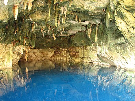
- Cenotes of Cuzamá: Bolonchojol, Chacsinicche, Chelentun[10]
- Hacienda Cuchbalam
References
- ^ "Presidentes Municipales" (in Spanish). Mérida, Mexico: PRI yucatan. 23 January 2014. Archived from the original on 3 July 2015. Retrieved 5 July 2015.
- ^ a b c d e f g h "Municipios de Yucatán »Cuzamá" (in Spanish). Retrieved 5 July 2015.
- ^ a b "Mexico In Figures:Cuzamá, Yucatán". INEGI (in Spanish and English). Aguascalientes, México: Instituto Nacional de Estadística y Geografía (INEGI). Archived from the original on 6 May 2015. Retrieved 5 July 2015.
- ^ García Bernal, Manuela Cristina (1978). Población y encomienda en Yucatán bajo los Austrias (in Spanish). Sevilla: Escuela de Estudios Hispano-Americanos. p. 119. ISBN 978-8-400-04399-5. Retrieved 3 July 2015.
- ^ a b c "Cuzamá". inafed (in Spanish). Mérida, Mexico: Enciclopedia de Los Municipios y Delegaciones de México. Archived from the original on 8 May 2014. Retrieved 5 July 2015.
- ^ "Chunkanán". PueblosAmerica (in Spanish). PueblosAmerica. 2005. Retrieved 5 July 2015.
- ^ "Cuzamá". PueblosAmerica (in Spanish). PueblosAmerica. 2005. Retrieved 5 July 2015.
- ^ "Eknakán". PueblosAmerica (in Spanish). PueblosAmerica. 2005. Retrieved 5 July 2015.
- ^ "Nohchakán". PueblosAmerica (in Spanish). PueblosAmerica. 2005. Retrieved 5 July 2015.
- ^ "The Cenotes of Cuzama". Yucatan Living. Yucatan Living. Archived from the original on 6 July 2015. Retrieved 6 July 2015.
Mérida (capital) | |||||||||||||||
| Topics |  | ||||||||||||||
| Metros | |||||||||||||||
| Larger cities | |||||||||||||||
| Smaller cities |
| ||||||||||||||
| Municipalities |
| ||||||||||||||